- The difference between weather and climate, and why India is called a land of “unity in the monsoon, diversity in its expression”
- The six factors that decide the climate of any place in India
- What the ITCZ is, and how its shift causes the monsoon winds to reverse twice a year
- The four seasons the India Meteorological Department recognises, and what each one looks like
- How the southwest monsoon splits into the Arabian Sea and Bay of Bengal branches, and why some places stay dry despite being close to the coast
- Where India gets the most and the least rainfall, and how the monsoon shapes the country’s economy and daily life
1Weather, Climate and India’s Regional Diversity
Look around you: your school uniform changes with the season, and so does the water you drink. These everyday changes are weather changing. Add them up over many years and you get the climate of a place.
Weather is the momentary, short-term state of the atmosphere, changing within a day or a week.
Climate is the average of weather conditions over a long period of time, so long that a real change may take 50 years or more to show up.
India’s overall climate type is hot monsoonal, the same broad type found across South and Southeast Asia. But “monsoonal” does not mean “the same everywhere”: the same monsoon climate looks very different from place to place.
The monsoon regime is what ties India together with the rest of South and Southeast Asia: it is the single climatic thread running through Kerala, Uttar Pradesh, Bihar and Tamil Nadu alike. But this broad unity should never be mistaken for sameness: the regional differences in wind pattern, temperature, rainfall, the rhythm of the seasons and the degree of wetness or dryness are real, and are best understood as sub-types of one monsoon climate, not as separate climates.
1.1 How different can two Indian places be?
| What is being compared | Place A | Place B |
|---|---|---|
| Summer vs winter extreme | Western Rajasthan: up to 55°C in summer | Near Leh: down to −45°C in winter |
| Same June day | Churu (Rajasthan): 50°C or more | Tawang (Arunachal Pradesh): about 19°C |
| Same December night | Drass (Ladakh): about −45°C | Thiruvananthapuram/Chennai: 20-22°C |
| Difference between day and night (diurnal range) | Kerala and the Andaman Islands: only 7-8°C | Thar Desert: 50°C by day, 15-20°C by night |
| Rainfall contrast | Very wet | Very dry |
|---|---|---|
| Annual rainfall (Meghalaya vs Rajasthan) | Cherrapunji & Mawsynram (Khasi Hills): over 1,080 cm/year | Jaisalmer (Rajasthan): rarely more than 9 cm/year |
| One day of rain (Garo Hills) | Tura can get in a single day what Jaisalmer gets in 10 years | — |
| Same July-August week | Ganga delta & coastal Odisha: storms almost every 3rd-5th day | Coromandal coast, 1,000 km south: stays dry |
| Timing of rain | Most of India: June-September | Tamil Nadu coast: rains in early winter instead |
“Explain the unity and diversity of India’s climate with examples” is a standard 125-word question. Structure your answer as: (1) state the unifying fact: the whole country has a monsoon-type climate; (2) give 2-3 contrasting number pairs from the tables above; (3) close with “these are regional sub-types of one monsoon climate, not different climates.”
2Factors Determining the Climate of India
India’s climate is controlled by a number of factors working together. Six of them matter most.
2.1 The six controls
Latitude
The Tropic of Cancer runs east-west through the middle of India. The area south of it is tropical (near the equator, so high temperatures all year with a small daily/annual range); the area north of it is sub-tropical and temperate (further from the equator, so an extreme climate with a large daily/annual range).
The Himalayan Mountains
Acting as an effective climatic divide, the towering Himalayas shield the subcontinent from cold winds blowing down from the Arctic across central and eastern Asia, and also trap the monsoon winds, forcing them to shed their moisture inside the subcontinent instead of moving on.
Distribution of Land and Water
India has the Indian Ocean on three sides and a continuous mountain wall in the north. Land heats and cools faster than water, so this creates different air-pressure zones over land and sea in different seasons, and it is exactly this pressure difference that reverses the monsoon winds.
Distance from the Sea
Places with a long coastline get an equable climate, moderated by the sea (Mumbai, the Konkan coast). Places deep in the interior lose that moderating effect and swing to extremes instead (Delhi, Kanpur, Amritsar).
Altitude
Temperature falls as height increases, because thinner air holds less heat. Agra and Darjiling sit on the same latitude, yet January temperature is 16°C in Agra and only 4°C in Darjiling.
Relief
The physical shape of the land decides how much rain falls where. The windward side of the Western Ghats and Assam get heavy rain (June-September); the southern plateau, sitting in the leeward shadow of the Western Ghats, stays comparatively dry.
3The Monsoon Mechanism: the ITCZ
Everything about the Indian monsoon starts with one shifting belt of low pressure near the equator.
The Inter Tropical Convergence Zone (ITCZ) is a low-pressure zone located at the equator, where trade winds from both hemispheres converge and air rises. In July it shifts to sit around 20°N-25°N, over the Gangetic plain, where it is also called the monsoon trough.
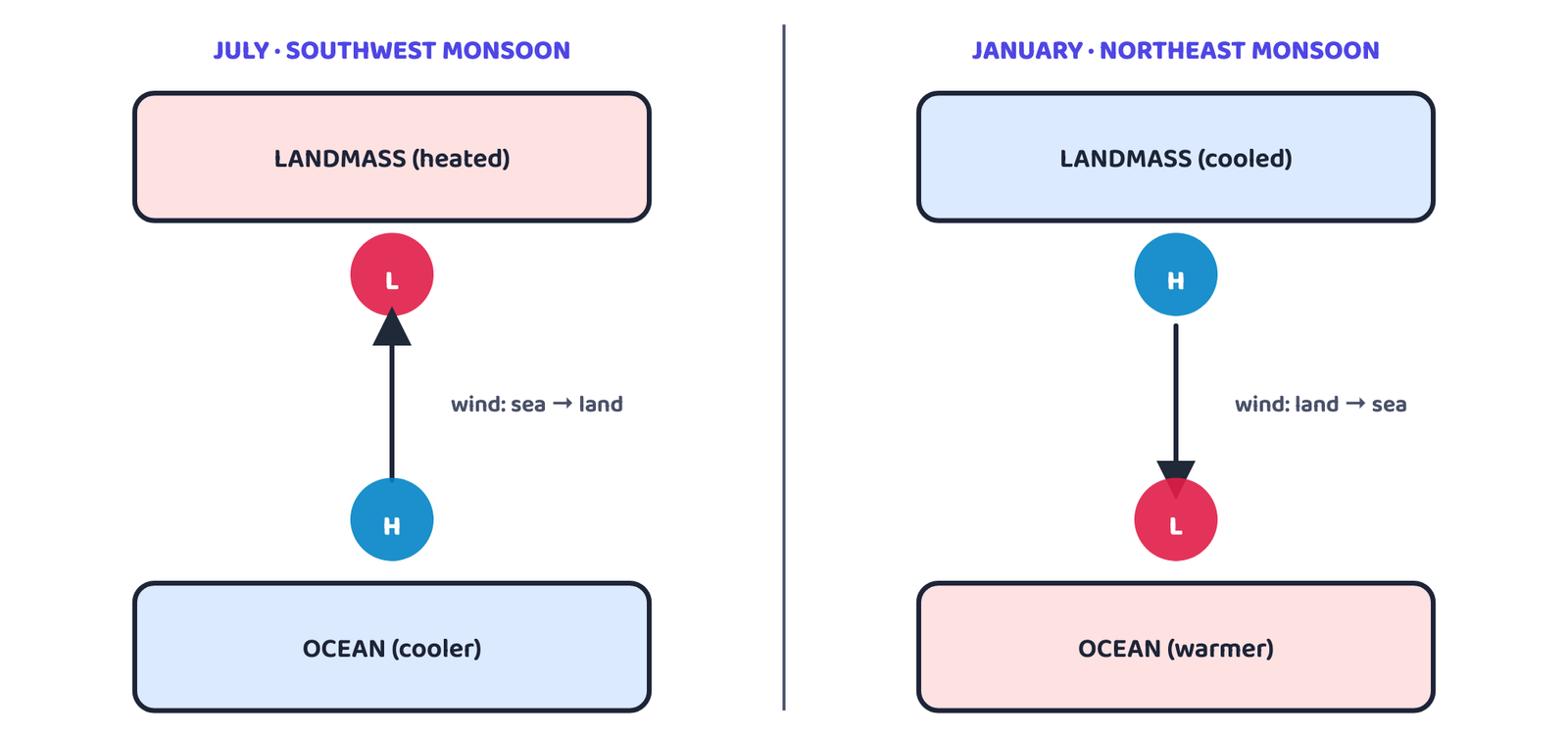
The onset of the monsoon is also linked to the withdrawal of the westerly jet stream from north of the Himalayas and the setting-in of an easterly jet stream along 15°N: this easterly jet is credited with triggering the actual “burst” of the monsoon. Name both jet streams if the question asks for the mechanism in detail.
“Break in the monsoon” does NOT mean the monsoon has ended for the year. It means a dry spell of a week or more during the rainy season, after rain has already been falling for some days. In northern India it happens when the monsoon trough/ITCZ shifts and rain-bearing storms become less frequent; on the west coast it happens when winds blow parallel to the coast instead of onto it.
India’s monsoon forecasters watch a Pacific Ocean phenomenon too. The Southern Oscillation is tracked by measuring the pressure difference between Tahiti (French Polynesia, East Pacific) and Port Darwin (northern Australia); the India Meteorological Department forecasts monsoon behaviour using 16 such indicators.
El Niño is a complex ocean-atmosphere event that recurs every 3-7 years: a warm current temporarily replaces the cold Peru (Humboldt) current off the coast of Peru, raising sea temperature there by about 10°C. This distorts the equatorial atmospheric circulation, disturbs evaporation over the sea, and reduces plankton, and therefore fish, in the affected waters. It is named “the Christ Child” because it tends to appear around Christmas, which is a summer month in the southern hemisphere. A strong El Niño in 1990-91 delayed the monsoon’s onset over most of India by 5 to 12 days.
4The Rhythm of the Seasons
The India Meteorological Department recognises four seasons in a normal year.
4.1 The Cold Weather Season
Cold weather sets in by mid-November across northern India; December and January are the coldest months, with a mean daily temperature below 21°C over most of the north, and night temperatures that can fall below freezing point in Punjab and Rajasthan.
Peninsular India has no clearly marked cold season at all: the sea’s moderating effect and closeness to the equator keep temperatures steady: Thiruvananthapuram’s January mean maximum is about 21°C, barely below its June figure of 29.5°C.
Pressure and winds: by 22 December the sun shines vertically over the Tropic of Capricorn, and a feeble high-pressure zone builds over the northern plain (isobars of 1019 mb and 1013 mb run through northwest India and the far south respectively). Light winds (3-5 km/hour) blow outward from this high towards the low over the Indian Ocean: westerly/northwesterly down the Ganga valley, northerly in the Ganga-Brahmaputra delta, and clearly northeasterly over the Bay of Bengal.
A western disturbance (also called a temperate cyclone) is a shallow cyclonic depression that originates over the eastern Mediterranean Sea and travels east across West Asia, Iran, Afghanistan and Pakistan, gaining moisture from the Caspian Sea and the Persian Gulf, before bringing winter rain and snow to northwest India.
Northwest India
Weak western disturbances bring light but valuable rain, and snow in the lower Himalayas, benefiting rabi crops. Delhi’s average winter rainfall is ~53 mm; Punjab and Bihar get 18-25 mm. Himalayan snow also feeds Himalayan rivers through summer.
Central India & northern peninsula
Get occasional winter rainfall too, though in smaller amounts.
Arunachal Pradesh & Assam
Receive 25-50 mm during these winter months.
Tamil Nadu & nearby coasts
The northeast monsoon (Oct-Nov), crossing the Bay of Bengal and picking up moisture, brings rain to the Tamil Nadu coast, southern Andhra Pradesh, southeast Karnataka and southeast Kerala. This is the exception the MCQ below is built on.
4.2 The Hot Weather Season
As the sun’s apparent position moves north towards the Tropic of Cancer in March, temperatures start climbing across north India; April, May and June are the hottest months there.
| Month / place | Typical day temperature |
|---|---|
| Most of India | 30-32°C |
| Deccan Plateau (March) | ~38°C |
| Gujarat & Madhya Pradesh (April) | 38-43°C |
| Northwest India (May) | ~48°C (heat belt has shifted further north) |
| South India | 26-32°C (milder, moderated by the peninsula’s sea exposure) |
Along the coast, isotherms run parallel to the coastline: temperature does not fall from north to south, it rises from the coast towards the interior instead, and the night’s minimum temperature rarely drops below 26°C anywhere in this belt.
Pressure and winds: the ITCZ shifts north to sit around 25°N in July, forming an elongated monsoon trough stretching from the Thar Desert (northwest) to Patna and the Chotanagpur plateau (east-southeast). This pulls in southwesterly winds along the west coast and the West Bengal coast, and easterly/southeasterly winds over north Bengal and Bihar; in reality, these are the same “displaced” equatorial easterlies moving towards their eventual monsoon role.
The hot, dry wind called “Loo” is not the same thing as a dust storm. Loo blows through the afternoon (sometimes into midnight) in the core of the low-pressure trough over northwest India; dust storms are separate, short-lived events common in the evenings of May in Punjab, Haryana, eastern Rajasthan and Uttar Pradesh, and actually bring some relief (light rain and a cool breeze) because they mark a sudden contact between dry and moist air.
| Local storm | Where | What it means |
|---|---|---|
| Mango shower | Kerala, coastal Karnataka | Pre-monsoon showers that help mangoes ripen early |
| Blossom shower | Kerala & nearby coffee tracts | Helps coffee flowers blossom |
| Nor’westers (“Kalbaisakhi”) | West Bengal & Assam (called “Bardoisila” in Assam) | Dreaded evening thunderstorms; useful for tea, jute and rice |
| Loo | Punjab to Bihar, worst between Delhi and Patna | Hot, dry, oppressing wind blowing through the plains |
4.3 The Southwest Monsoon Season
By early June, the northwest low has deepened enough to draw in the southeast trade winds of the southern hemisphere. After crossing the equator, warmed by equatorial currents and now carrying plenty of moisture, they turn southwesterly, which is why they are called the southwest monsoons.
As these winds reach land, relief and the thermal low over northwest India bend their direction, and the monsoon approaches India in two branches.
Two reasons, and a 2-mark question wants both: (1) it lies parallel to the Bay of Bengal branch’s track, so the branch runs past it rather than into it; (2) it sits in the rain-shadow of the Arabian Sea branch. This is also why Tamil Nadu instead gets its rain in the retreating/northeast monsoon season.
4.4 The Season of Retreating Monsoon
By late September the southwest monsoon weakens as the low-pressure trough over the Ganga plain moves south. It withdraws from western Rajasthan by the first week of September, and from Rajasthan, Gujarat, the western Ganga plain and the Central Highlands by month-end. The low sits over the northern Bay of Bengal by early October, moves over Karnataka and Tamil Nadu by early November, and is fully gone from the peninsula by mid-December.
Clear skies and rising temperature over still-moist ground make this season oppressive in a way that has its own name: “October heat.” Relief only comes in the second half of October, when temperature starts falling quickly, especially in the north.
North India stays dry through this season, but the eastern peninsula gets rain: October and November are its rainiest months, thanks to cyclonic depressions forming over the Andaman Sea and crossing the southern peninsula’s east coast. These tropical cyclones are highly destructive and target the thickly populated deltas of the Godavari, Krishna and Kaveri every year; some also strike West Bengal, Bangladesh and Myanmar. Such cyclones are much rarer in the Arabian Sea.
4.5 Traditional Indian Seasons
Alongside the IMD’s four seasons, Indian tradition divides the year into six two-monthly seasons, followed by people in north and central India based on age-old experience of the weather. This cycle does not match the more uniform seasons of South India.
| Season | Months (Indian calendar) | Months (Gregorian calendar) |
|---|---|---|
| Vasanta | Chaitra-Vaisakha | March-April |
| Grishma | Jyaistha-Asadha | May-June |
| Varsha | Sravana-Bhadra | July-August |
| Sharada | Asvina-Kartika | September-October |
| Hemanta | Margashirsa-Pausa | November-December |
| Shishira | Magha-Phalguna | January-February |
5Distribution of Rainfall
India’s average annual rainfall is about 125 cm, but the spread around that average is enormous.
| Category | Rainfall | Where |
|---|---|---|
| High | >200 cm (parts of Khasi & Jaintia Hills >1,000 cm) | West coast, Western Ghats, sub-Himalayan northeast, Meghalaya hills |
| Medium | 100-200 cm | Southern Gujarat, eastern Tamil Nadu, Odisha-Jharkhand-Bihar-eastern MP belt, northern Ganga plain along the sub-Himalayas, Cachar valley, Manipur |
| Low | 50-100 cm | Western Uttar Pradesh, Delhi, Haryana, Punjab, Jammu & Kashmir, eastern Rajasthan, Gujarat, Deccan Plateau |
| Inadequate | <50 cm | Parts of Andhra Pradesh, Karnataka, Maharashtra; Ladakh; most of western Rajasthan |
The Brahmaputra valley and its adjoining hills, despite being in the northeast, stay under 200 cm, a useful reminder that “northeast” does not automatically mean “highest rainfall” everywhere. Snowfall itself is restricted to the Himalayan region.
6Monsoons and the Economic Life of India
6.1 Eight ways the monsoon runs the economy
The axis of the farm calendar
About 64% of India’s people depend on agriculture for their living, and agriculture itself is built around the southwest monsoon.
Year-round growing season
Except in the Himalayas, temperature stays above the threshold for growing crops all year, so the monsoon’s timing (not the temperature) is the real limit on farming.
Crop variety from regional variation
Regional differences within the monsoon climate let India grow many different types of crops in different regions.
Droughts and floods
Rainfall variability brings droughts or floods to some part of the country almost every year.
Timeliness matters as much as amount
Agricultural prosperity depends heavily on rain arriving on time and being well distributed; a failure hits hardest where irrigation is undeveloped.
Soil erosion
A sudden, violent monsoon burst can cause serious soil erosion over large areas.
Winter rain helps rabi crops
Winter rainfall brought by western disturbances (temperate cyclones) is highly beneficial for the rabi crop.
Shapes daily life too
India’s regional climatic variation shows up directly in the country’s variety of food, clothing and house types.
7Global Warming
Change is the law of nature, and climate has changed before: geological evidence shows large parts of the earth were once under ice. Climate is still changing today, mostly imperceptibly, and human activity is now a major driver alongside natural causes.
The greenhouse effect is the warming caused when gases in the atmosphere (carbon dioxide, methane, chlorofluorocarbons, nitrous oxide) absorb long-wave radiation from the earth and re-radiate it as heat, trapping warmth that would otherwise escape to space.
Carbon dioxide, released in large quantities by burning fossil fuels, is the biggest single concern, but methane, CFCs and nitrous oxide (though present in much smaller amounts) are better absorbers of long-wave radiation than CO₂ per molecule, so they punch above their weight in enhancing the greenhouse effect.
The same monsoon that unites India’s climate is also the reason no two Indian states experience that climate the same way.
the one idea to carry out of this chapter
- Can I explain why the ITCZ’s shift reverses the monsoon winds, using the pressure diagram?
- Can I name all six factors controlling India’s climate with one example each?
- Can I trace both branches of the southwest monsoon and name where each one rains?
- Can I give two reasons the Tamil Nadu coast stays dry in the rainy season?
- Can I list the four IMD seasons in order with one key fact about each?
- Weather = short-term; Climate = long-term average. India’s climate type: hot monsoonal.
- Six climate controls: latitude, the Himalayas, land-sea distribution, distance from the sea, altitude, relief.
- ITCZ shifts north (~25°N, July) to trigger the SW monsoon; shifts south in winter to trigger the NE monsoon.
- Monsoon enters: Kerala 1 June → Mumbai/Kolkata 10-13 June → whole country by mid-July.
- Break in the monsoon = a dry spell mid-season, not withdrawal. El Niño can delay onset (1990-91: 5-12 days).
- 4 seasons: cold weather, hot weather, SW monsoon, retreating monsoon.
- SW monsoon has two branches: Arabian Sea (3 sub-branches) and Bay of Bengal (2 sub-branches).
- Mawsynram = highest rainfall in the world. Jaisalmer = one of the driest places in India.
- 64% of Indians depend on agriculture, which runs on the monsoon’s timing, not just its total amount.
- 1 markWhat causes rainfall on the coastal areas of Tamil Nadu in the beginning of winter?
(a) Southwest monsoon(b) Temperate cyclones(c) Northeastern monsoon(d) Local air circulation - 1 markWhat proportion of India’s area receives annual rainfall less than 75 cm?
(a) Half(b) One-third(c) Two-thirds(d) Three-fourths - 1 markWhich one of the following is NOT a fact regarding South India?
(a) Diurnal range of temperature is less here(b) Annual range of temperature is less here(c) Temperatures here are high throughout the year(d) Extreme climatic conditions are found here - 1 markWhat happens when the sun shines vertically over the Tropic of Capricorn?
(a) High pressure develops over northwestern India due to low temperatures(b) Low pressure develops over northwestern India due to high temperatures(c) No change in temperature or pressure occurs in northwestern India(d) ‘Loo’ blows in northwestern India - 1 markThe ITCZ is also known, when it sits over the Gangetic plain in July, as the:
(a) Jet stream(b) Monsoon trough(c) Rain-shadow belt(d) Western disturbance - 1 markWhich place holds the record for the highest average annual rainfall in the world?
(a) Cherrapunji(b) Mawsynram(c) Tura(d) Shillong - 1 markNor’westers are called “Bardoisila” in which state?
(a) West Bengal(b) Odisha(c) Assam(d) Bihar - 1 markThe Arabian Sea branch of the monsoon that strikes the Saurashtra Peninsula and Kachchh eventually joins:
(a) The Bay of Bengal branch, in Punjab and Haryana(b) The retreating monsoon over Rajasthan(c) The northeast monsoon over Tamil Nadu(d) It does not join any other branch - 1 markWhich two cities are compared to show that altitude, not latitude, is deciding the temperature difference?
(a) Delhi and Chennai(b) Agra and Darjiling(c) Mumbai and Kolkata(d) Jaisalmer and Cherrapunji - 1 markBy when does the low-pressure centre of the retreating monsoon completely leave the Peninsula?
(a) End of September(b) Early October(c) Early November(d) Mid-December
- 1 mark
Assertion (A): The southern plateau, though close to the Western Ghats, receives comparatively little rainfall in the southwest monsoon season.
Reason (R): The southern plateau lies in the leeward, rain-shadow side of the Western Ghats. - 1 mark
Assertion (A): Delhi and Amritsar experience a more extreme climate than Mumbai.
Reason (R): Being far from the sea, they lose the sea’s moderating influence on temperature. - 1 mark
Assertion (A): A “break in the monsoon” means the monsoon has fully withdrawn from India for the year.
Reason (R): Once the ITCZ shifts even slightly, no more rain-bearing systems can form for the rest of the year. - 1 mark
Assertion (A): Peninsular India has no clearly marked cold weather season.
Reason (R): Its nearness to the sea and to the equator keeps its seasonal temperature range small.
- 1 markWhich branch of the monsoon is chiefly responsible for whatever rain reaches western Rajasthan?
- 2 marksName the local storm the tea planter in Assam might see even before the southwest monsoon sets in, and explain why it is useful to his crop.
- 2 marksGive one reason western Rajasthan gets so little rain despite being reached by the same monsoon system that floods Assam.
- 2 marksWhat is the Inter-Tropical Convergence Zone (ITCZ)?
- 2 marksWhat is meant by “bursting of the monsoon”? Name the place in India that receives the highest rainfall.
- 2 marksWhich type of cyclones cause winter rainfall in northwest India, and where do they originate?
- 3 marksGive two reasons why the Tamil Nadu coast remains dry during the southwest monsoon season.
- 2 marksWhy does Peninsular India not have a well-marked cold weather season?
- 3 marksExplain, with one example each, how latitude and altitude affect the climate of a place in India.
- 2 marksWhat is a rain-shadow area? Name one such area created by the Western Ghats.
- 3 marksBriefly explain how El Niño affects the Indian monsoon, with the example of 1990-91.
- 2 marksWhy is the word “Loo” always associated with the hot weather season, not the monsoon season?
- 5 marksNotwithstanding the broad climatic unity, the climate of India has many regional variations. Elaborate this statement giving suitable examples.
- 5 marksHow many distinct seasons does the India Meteorological Department recognise in India? Describe the weather conditions of any one season in detail.
- 5 marksDescribe the mechanism of the onset of the southwest monsoon, from the heating of the landmass in April-May to its arrival over Kerala.
- 5 marksTrace the two branches of the southwest monsoon and explain how each one further splits as it moves over India.