- How to tell natural vegetation apart from planted vegetation, and why India has so many different types of it
- The five types of Indian forests, where each grows, and which species mark each one
- How vegetation changes with altitude in the Himalayas, and why the southern hill forests are called Sholas
- What a wetland, a Ramsar site and a mangrove forest are, and where India’s major ones lie
- The Forest Policy’s aims, and the difference between social, agro, community and farm forestry
- Why wildlife is declining, and what the Wildlife Act, Project Tiger, Project Elephant and Biosphere Reserves each do about it
1What Is Natural Vegetation?
Natural vegetation is plant cover that has grown on its own, undisturbed for a long time, so that each species has adjusted itself to the local climate and soil as fully as possible. A mango tree in a village orchard and the same species growing wild in a forest are botanically identical, but only the wild one counts as natural vegetation: the orchard tree grows under human care, on a spot a person chose for it.
Natural vegetation is a plant community that has been left undisturbed over a long time, so that its species can adjust themselves to climate and soil conditions as fully as possible.
India’s vegetation changes sharply from region to region because its climate and soil do. The Himalayan heights carry temperate forest, the Western Ghats and Andaman & Nicobar Islands carry tropical rain forest, and the deserts of Rajasthan carry only cacti and thorny scrub, all in one country.
2Types of Indian Forests
On the basis of the dominant vegetation type and the climate of a region, Indian forests fall into five groups.
2.1 Tropical Evergreen and Semi-Evergreen Forests
Found on the western slope of the Western Ghats, in the hills of the north-eastern region and in the Andaman & Nicobar Islands: warm, humid areas with more than 200 cm of annual rainfall and a mean annual temperature above 22°C.
A tropical evergreen forest grows where annual rainfall exceeds 200 cm and mean temperature stays above 22°C. It is well stratified, with shrubs and creepers near the ground, short trees above them, and the tallest trees, up to 60 m or more, on top, and it has no fixed season for shedding leaves, so it looks green all year.
| Feature | Evergreen forest | Semi-evergreen forest |
|---|---|---|
| Where found | Western Ghats’ western slope, NE hills, Andaman & Nicobar Islands | Less-rainy parts of the same regions |
| Rainfall / temperature | Over 200 cm; above 22°C | Slightly lower rainfall |
| Character | Green all year, well stratified, trees up to 60 m | Mix of evergreen and moist deciduous trees; climbers add the evergreen look |
| Main species | Rosewood, mahogany, aini, ebony | White cedar, hollock, kail |
The British valued these forests for timber and cleared them on a large scale. The oak forests of Garhwal and Kumaon were replaced by pine (chir), needed for railway sleepers, and other stretches were cleared for tea, rubber and coffee plantations. Forests protected for centuries were suddenly used purely for commercial gain.
2.2 Tropical Deciduous (Monsoon) Forests
These are the most widespread forests in India, also called monsoon forests, spread over regions receiving 70-200 cm of rainfall. Based on water availability they split into moist and dry deciduous forest.
Moist deciduous
- Rainfall 100-200 cm
- NE states’ Himalayan foothills, Western Ghats’ eastern slopes, Odisha
- Teak, sal, shisham, hurra, mahua, amla, semul, kusum, sandalwood
Dry deciduous
- Rainfall 70-100 cm
- Rainier parts of the Peninsula, Uttar Pradesh and Bihar plains
- Tendu, palas, amaltas, bel, khair, axlewood
Dry deciduous forest gives the land a parkland look: open grass with teak and other trees scattered through it. But as the dry season begins the trees shed their leaves completely, and the same land looks like a bare grassland. In the western and southern parts of Rajasthan, low rainfall and overgrazing leave the vegetation cover very scanty.
2.3 Tropical Thorn Forests
These occur where annual rainfall is below 50 cm: the semi-arid tracts of south-west Punjab, Haryana, Rajasthan, Gujarat, Madhya Pradesh and Uttar Pradesh.
A tropical thorn forest is a mix of grasses and thorny shrubs found where rainfall is under 50 cm a year; plants stay leafless for most of the year, giving the land a scrub-like look.
Important species are babool, ber, wild date palm, khair, neem, khejri and palas, with tussocky grass growing up to 2 m tall as the undergrowth.
3Montane Forests
In hilly areas, temperature falls as altitude rises, and natural vegetation changes to match. India’s montane forests are of two kinds: the northern (Himalayan) mountain forests and the southern (Peninsular) mountain forests.
3.1 Northern (Himalayan) Mountain Forests
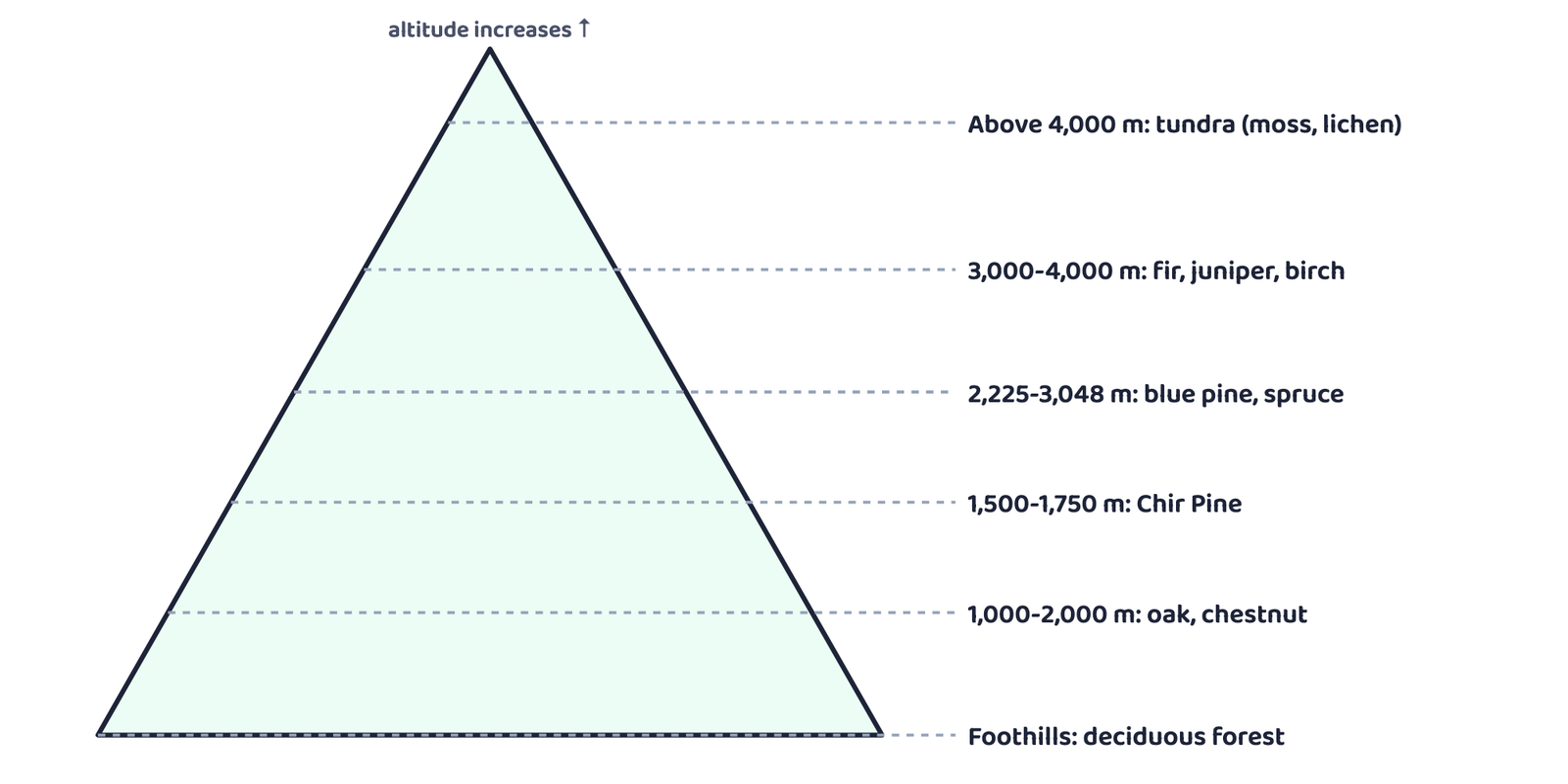
Between the pine belt and the blue pine/spruce belt, chinar and walnut grow in the western Himalaya, the wood used for Kashmir’s famous handicrafts, and Deodar, a highly valued, durable timber species, grows further west still. Temperate grasslands appear within the upper belts, giving way to Alpine forests and pastures above them. Those high pastures are used for transhumance (seasonal grazing migration) by the Gujjars, Bakarwals, Bhotiyas and Gaddis. Because the southern-facing Himalayan slopes get more rain than the drier north-facing ones, they carry noticeably thicker forest cover.
3.2 Southern (Peninsular) Mountain Forests
| Feature | Southern (Peninsular) mountain forests |
|---|---|
| Where found | Three separate patches: the Western Ghats, the Vindhyas and the Nilgiris |
| Why temperate so low | Only about 1,500 m above sea level, yet temperate, because these hills sit close to the tropics |
| Zonation | Temperate higher up, subtropical lower down (Kerala, Tamil Nadu, Karnataka) |
| Local name | The temperate forests here are called Sholas, in the Nilgiri, Anaimalai and Palani hills |
| Main species | Magnolia, laurel, cinchona, wattle |
| Also found in | The Satpura and Maikal ranges |
Sholas are the temperate forests of the southern (Peninsular) mountain forests, found in the Nilgiri, Anaimalai and Palani hills at altitudes of only about 1,500 m.
4Littoral and Swamp Forests
India has a rich variety of wetland habitats: a total of 3.9 million hectares, about 70% of it under paddy cultivation. Chilika Lake (Odisha) and Keoladeo National Park (Bharatpur) are protected as waterfowl habitats under the Ramsar Convention.
4.1 Wetlands and the Ramsar Convention
A wetland is land where water covers the soil, or is present at or near the surface, for all or part of the year, supporting habitats such as marshes, lakes and lagoons.
The Ramsar Convention (the Convention on Wetlands of International Importance) is an international convention, an agreement among member states of the United Nations, that protects wetlands recognised as internationally important.
| # | Wetland category | Region |
|---|---|---|
| 1 | Reservoirs of the Deccan Plateau + southern west-coast lagoons | South India |
| 2 | Saline expanses | Rajasthan, Gujarat, Gulf of Kachchh |
| 3 | Freshwater lakes and reservoirs (includes Keoladeo National Park) | Gujarat to Madhya Pradesh, via Rajasthan |
| 4 | Delta wetlands and lagoons (includes Chilika Lake) | India’s east coast |
| 5 | Freshwater marshes | Gangetic Plain |
| 6 | Floodplains and hill/foothill marshes & swamps | Brahmaputra Valley, north-east India, Himalayan foothills |
| 7 | Montane lakes and rivers | Kashmir and Ladakh |
| 8 | Mangrove and other island-arc wetlands | Andaman & Nicobar Islands |
4.2 Mangrove Forests
A mangrove forest is a stand of salt-tolerant plant species growing along the coast in salt marshes, tidal creeks, mud flats and estuaries, giving shelter to a wide variety of birds.
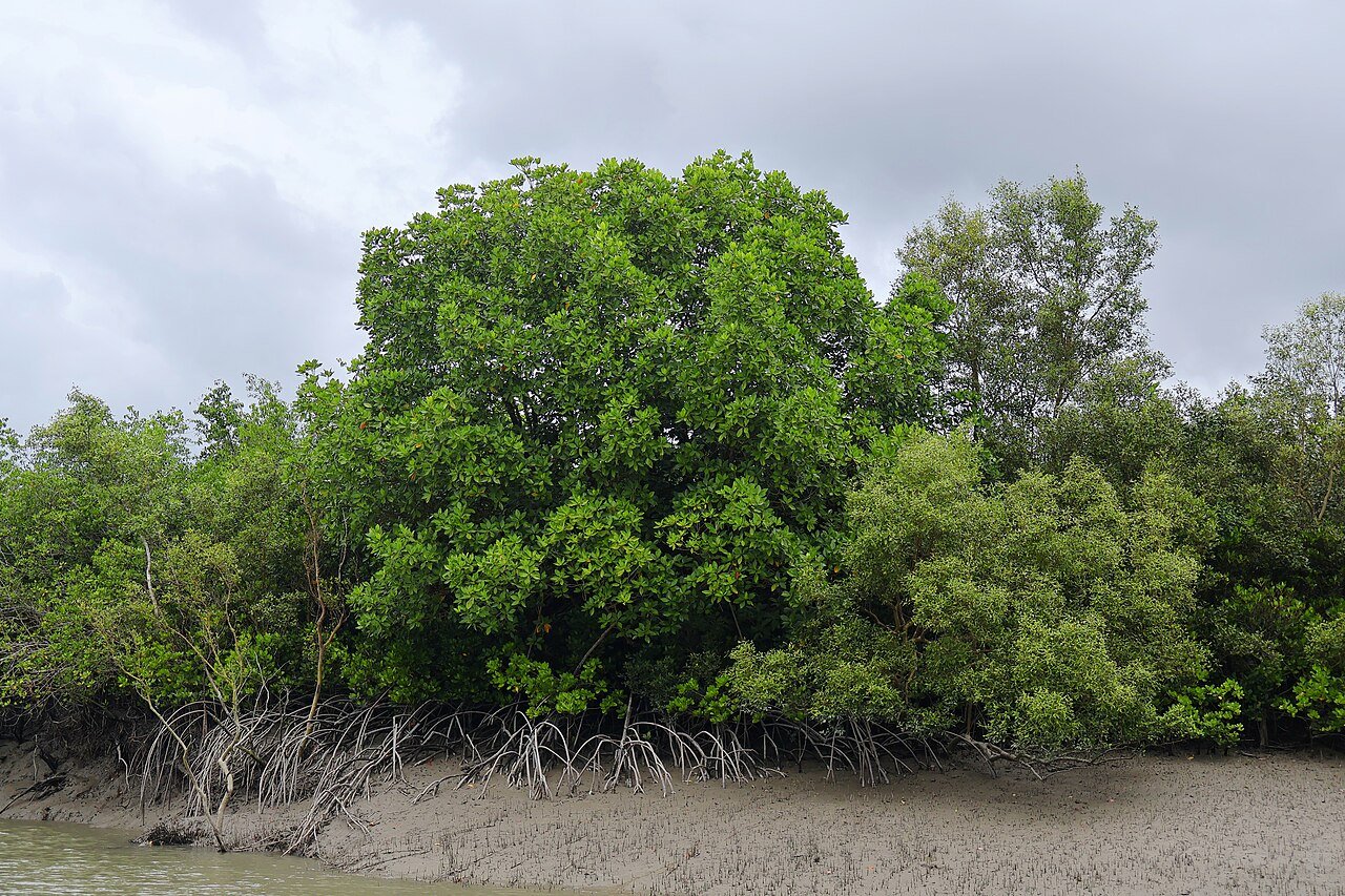
Mangroves are most developed in the Andaman & Nicobar Islands and the Sunderbans of West Bengal; the Mahanadi, Godavari and Krishna deltas are also significant. Encroachment threatens many of these forests, which is why they need active conservation.
5Forest Conservation
Forests have an intricate relationship with life and environment, giving direct and indirect benefits to the economy and society. That is why the Government of India adopted a national Forest Policy in 1952, modified in 1988. The new policy stresses sustainable forest management: conserving and expanding forest reserves while still meeting the needs of local people.
5.1 The Forest Policy
| # | Aim of the Forest Policy, 1988 |
|---|---|
| 1 | Bring 33% of the geographical area under forest cover |
| 2 | Maintain environmental stability; restore ecological balance where disturbed |
| 3 | Conserve the country’s natural heritage, biological diversity and genetic pool |
| 4 | Check soil erosion, desert extension, floods and droughts |
| 5 | Increase forest cover through social forestry and afforestation on degraded land |
| 6 | Raise forest productivity so timber, fuel, fodder and food reach forest-dependent people, and encourage substitutes for wood |
| 7 | Build a mass people’s movement, involving women, to plant trees and stop felling |
5.2 Social, Agro, Community and Farm Forestry
Social forestry means managing and protecting forests, and afforesting barren land, to help environmental, social and rural development. The National Commission on Agriculture (1976) split it into Urban, Rural and Farm forestry.
| Type | What it covers |
|---|---|
| Urban forestry | Raising and managing trees on public/private land in and around cities: green belts, parks, roadside avenues, industrial and commercial green belts |
| Rural forestry | Promotes agro-forestry (trees + crops on the same land, including waste patches) and community forestry (trees on village pasture, temple land, roadsides, canal banks, railway strips, school land, for the whole community’s benefit, landless people included) |
| Farm forestry | Farmers grow trees on their own farmland for commercial or non-commercial use; forest departments give free seedlings to small and medium farmers |
5.3 Forests and Tribal Life
Forest and tribal communities cannot really develop, one without the other. The age-old traditional knowledge tribal people hold about forestry can, and should, be used in forest development.
Rather than treating tribal people only as collectors of minor forest produce, the policy sees them as partners and growers in conservation.
To many tribal communities, the forest is home, livelihood and existence. It gives food, fruit, edible leaves, honey, roots and game, along with the material to build houses and practise crafts.
6Wildlife and Protected Areas
6.1 Wildlife in India: Why It Is Declining
It is estimated that 4-5% of all the plant and animal species known on Earth are found in India, a result of the country’s great diversity of ecosystems, preserved and supported over centuries. Human activity has disturbed many of these habitats, and some species now stand at the brink of extinction.
Industrial exploitation
Industrial and technological advancement sped up the exploitation of forest resources.
Land cleared
Land taken for agriculture, settlements, roads, mining and reservoirs.
Fodder & fuelwood pressure
Lopping for fodder and fuelwood, plus timber removal by local people.
Grazing
Domestic cattle grazing damages wildlife habitats.
Hunting & poaching
Once elite sport, hunting has become commercial poaching today.
Forest fires
Fires destroy both forest cover and the wildlife living in it.
6.2 Wildlife Conservation: Laws and Projects
India has a long tradition of protecting wildlife, reflected even in old stories like the Panchtantra. That tradition is now backed by law and by dedicated conservation projects.
The Wildlife (Protection) Act, 1972 is the main legal framework for protecting India’s wildlife. It has two objectives: to protect endangered species listed in its schedule, and to give legal backing to National Parks, sanctuaries and closed areas. It was comprehensively amended in 1991, making punishments stricter and extending protection to specified plant species too.
| Scheme | Launched | Objective | Coverage |
|---|---|---|---|
| Project Tiger | 1973 | Maintain a viable tiger population for scientific, aesthetic, cultural and ecological value; preserve natural heritage | 9 reserves (16,339 km²) in 1973, grown to 58 reserves (84,487 km² core habitat) across 18 states today |
| Project Elephant | 1992 | Long-term survival of wild elephant populations | Implemented in 18 states |
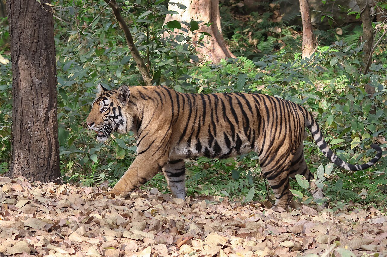
India now holds more than 75% of the world’s tiger population.
Beyond Project Tiger and Project Elephant, the government also runs the Crocodile Breeding Project, Project Hangul (for the Kashmir stag) and a conservation project for the Himalayan Musk Deer.
6.3 Biosphere Reserves
A Biosphere Reserve is a unique, representative ecosystem, terrestrial and coastal, internationally recognised under UNESCO’s Man and Biosphere (MAB) Programme.
A Biosphere Reserve is a representative terrestrial or coastal ecosystem recognised internationally under UNESCO’s Man and Biosphere (MAB) Programme, aiming at three linked objectives: conservation of biodiversity and genetic resources, sustainable development that uses the area’s resources without depleting them, and logistic support for research, education and monitoring.
India has 18 Biosphere Reserves; 12 of them are recognised by UNESCO on the World Network of Biosphere Reserves.
| # | Biosphere Reserve | Year | State(s)/UT |
|---|---|---|---|
| 1 | Nilgiri | 1986 | Tamil Nadu, Kerala, Karnataka |
| 2 | Nanda Devi | 1988 | Uttarakhand |
| 3 | Nokrek | 1988 | Meghalaya |
| 4 | Manas | 1989 | Assam |
| 5 | Sunderban | 1989 | West Bengal |
| 6 | Gulf of Mannar | 1989 | Tamil Nadu |
| 7 | Great Nicobar | 1989 | Andaman & Nicobar Islands |
| 8 | Similipal | 1994 | Odisha |
| 9 | Dibru-Saikhowa | 1997 | Assam |
| 10 | Dehang Debang | 1998 | Arunachal Pradesh |
| 11 | Pachmarhi | 1999 | Madhya Pradesh |
| 12 | Khangchendzonga | 2000 | Sikkim |
| 13 | Agasthyamalai | 2001 | Tamil Nadu, Kerala |
| 14 | Achanakmar-Amarkantak | 2005 | Madhya Pradesh, Chhattisgarh |
| 15 | Kachchh | 2008 | Gujarat |
| 16 | Cold Desert | 2009 | Himachal Pradesh |
| 17 | Seshachalam | 2010 | Andhra Pradesh |
| 18 | Panna | 2011 | Madhya Pradesh |
Bold names are the 12 Biosphere Reserves recognised by UNESCO on the World Network of Biosphere Reserves.
- Five forest types, sorted by rainfall: Evergreen (over 200 cm), Deciduous (70-200 cm), Thorn (under 50 cm), plus Montane (altitude-driven) and Littoral & Swamp (coastal wetlands)
- Moist deciduous needs more rain (100-200 cm) than dry deciduous (70-100 cm)
- Montane forests: northern (Himalayan) zones by altitude; southern (Peninsular) ones are called Sholas
- Mangroves cover 4,992 km², 7% of the world’s total, concentrated in the Sunderbans and Andaman & Nicobar Islands
- Forest Policy: 1952, modified 1988; targets 33% forest cover
- Social forestry has three arms: Urban, Rural (agro- + community forestry) and Farm forestry
- Wildlife (Protection) Act: 1972, amended 1991; 107 National Parks, 573 Wildlife Sanctuaries
- Project Tiger (1973): 9 reserves grew to 58; tiger count rose from 1,411 (2006) to 3,682 (2023). Project Elephant (1992): 18 states
- 18 Biosphere Reserves in India, 12 UNESCO-recognised, balancing conservation, development and research
- 1 markSandalwood is an example of:
(a) Evergreen forest(b) Deciduous forest(c) Deltaic forest(d) Thorny forest - 1 markWhat was the purpose of Project Tiger?
(a) To kill tigers(b) To put tigers in the zoo(c) To protect tigers from illegal hunting(d) To make films on tigers - 1 markThe Nanda Devi Biosphere Reserve is situated in:
(a) Bihar(b) Uttar Pradesh(c) Uttarakhand(d) Odisha - 1 markHow many of India’s Biosphere Reserves are recognised by UNESCO?
(a) One(b) Two(c) Twelve(d) Four - 1 markWhat proportion of the country’s area does the Forest Policy target under forest cover?
(a) 33%(b) 44%(c) 55%(d) 22% - 1 markWhich forest type is also called the “monsoon forest”?
(a) Evergreen(b) Tropical deciduous(c) Thorn(d) Montane - 1 markThe Sholas are found in the:
(a) Himalaya(b) Nilgiri, Anaimalai and Palani hills(c) Thar desert(d) Sunderbans - 1 markIndia’s mangrove forests cover about:
(a) 2,992 km²(b) 4,992 km²(c) 6,992 km²(d) 8,992 km²
- 1 mark
Assertion (A): Deodar wood is considered highly valuable.
Reason (R): It is a durable wood used mainly in construction activity. - 1 mark
Assertion (A): Tropical thorn forests are associated with very heavy rainfall regions.
Reason (R): These forests occur where annual rainfall is less than 50 cm. - 1 mark
Assertion (A): Mangrove forests are highly developed in the Sunderbans of West Bengal.
Reason (R): India’s mangroves cover about 33% of the world’s total mangrove area.
- Name the forest type found where rainfall is below 50 cm.
- In which year was the Wildlife (Protection) Act passed?
- What is the local name for the temperate forests of the Nilgiri, Anaimalai and Palani hills?
- Name the two Ramsar sites mentioned in this chapter.
- In how many states is Project Elephant implemented?
- What percentage of the country’s area does the Forest Policy aim to bring under forest cover?
- What is natural vegetation? Under what climatic conditions do tropical evergreen forests develop?
- What do you understand by social forestry?
- Define Biosphere Reserves.
- What is the difference between forest area and forest cover?
- Name any two mangrove-rich areas of India besides the Sunderbans.
- List three species found in tropical thorn forests.
- What steps have been taken to conserve forests in India?
- How can people’s participation be effective in conserving forests and wildlife?
- Describe the northern (Himalayan) mountain forests and how vegetation changes with altitude.
- Explain the objectives and achievements of Project Tiger in India.