- The three approaches to classifying climate, and why Koeppen’s is the one everybody actually uses
- How to read Koeppen’s letter codes, so “Aw” or “BSh” tells you the climate at a glance
- The defining features and world regions of all five climate groups and their fourteen types
- Why climate change is a completely natural process, with evidence from rocks, trees and history
- The astronomical and terrestrial causes that make climate change happen
- What the greenhouse effect actually is, and how it is connected to global warming and the Kyoto Protocol
1Koeppen’s Scheme of Classification of Climate
The world has an enormous variety of climates. To study them at all, geographers first sort them into groups, the same way a librarian sorts books into sections before anyone can find one. This sorting is called climate classification, and there is more than one way to do it.
1.1 Three broad approaches to classifying climate
Empirical
Based on observed data, mainly actual records of temperature and rainfall. This is the approach Koeppen used.
Genetic
Tries to organise climates according to their causes, for example the air masses or pressure belts that produce them.
Applied
Built for one specific purpose, such as classifying climate for farming or for building design.
A very common one-mark question asks which type Koeppen’s scheme belongs to. The answer is always Empirical, never Genetic or Applied, because it is built entirely from actual temperature and rainfall records.
1.2 Koeppen’s method
The most widely used climate classification in the world was developed by V. Koeppen. He noticed something useful: the type of plants growing in a place is closely tied to its climate. So instead of inventing a new set of climate boundaries from scratch, he picked certain values of temperature and rainfall, matched them to where different kinds of vegetation actually grow, and used those matching values to define his climate types.
Koeppen’s classification is an empirical scheme of climate classification based on mean annual and mean monthly temperature and precipitation data, developed by V. Koeppen in 1918 and still in use today, though modified since.
Koeppen introduced a neat shorthand: capital letters for the big climate groups, and small letters for the finer types within each group. He recognised five major groups, four decided by temperature and one by precipitation.
| Letter | Group | Defining feature |
|---|---|---|
| A | Tropical | Average temperature of the coldest month is 18°C or higher |
| B | Dry Climates | Potential evaporation exceeds precipitation |
| C | Warm Temperate (Mid-latitude) | Coldest month’s average temperature is below 18°C but above minus 3°C |
| D | Cold Snow Forest | Average temperature of the coldest month is minus 3°C or below |
| E | Cold Climates | Average temperature for all months is below 10°C |
Learn this table word for word, it is asked directly as a 4 or 5 mark question almost every year. Remember: A, C, D, E are humid climates; B alone is dry.
1.3 How the small letters build a type
Each capital-letter group is broken down further into types, shown with small letters, based on how rainfall and temperature change with the seasons.
| Small letter | Meaning |
|---|---|
| f | No dry season |
| m | Monsoon climate |
| w | Winter dry season |
| s | Summer dry season |
A separate set of small letters, a, b, c, d, marks how severe the temperature is, used mainly with Groups C and D. Group B is subdivided differently, using capital letters instead: S for steppe (semi-arid) and W for true desert.
Capital letter = which GROUP. Small letter = which TYPE inside it.
So in “Cfa”, the capital C tells you the group (Warm Temperate), and the small letters f and a tell you the type (no dry season, warm summer).
1.4 The full list of Koeppen’s climate types
| Group | Type | Code | Characteristics |
|---|---|---|---|
| A: Tropical Humid | Tropical wet | Af | No dry season |
| Tropical monsoon | Am | Monsoonal, short dry season | |
| Tropical wet and dry | Aw | Winter dry season | |
| B: Dry Climate | Subtropical steppe | BSh | Low-latitude semi-arid or dry |
| Subtropical desert | BWh | Low-latitude arid or dry | |
| Mid-latitude steppe | BSk | Mid-latitude semi-arid or dry | |
| Mid-latitude desert | BWk | Mid-latitude arid or dry | |
| C: Warm Temperate | Humid subtropical | Cfa | No dry season, warm summer |
| Mediterranean | Cs | Dry, hot summer | |
| Marine west coast | Cfb | No dry season, warm and cool summer | |
| D: Cold Snow Forest | Humid continental | Df | No dry season, severe winter |
| Subarctic | Dw | Winter dry and very severe | |
| E: Cold Climates | Tundra | ET | No true summer |
| Polar ice cap | EF | Perennial ice |
Do not try to memorise this by drawing a world map of shaded climate zones, the exam does not ask for one and a hand-drawn map is easy to get wrong. Learn each type by its code, its one-line characteristic, and two or three real regions where it occurs, exactly as given below.
2Group A: Tropical Humid Climates
Tropical humid climates exist between the Tropic of Cancer and the Tropic of Capricorn. The sun stays almost overhead all year, and the Inter Tropical Convergence Zone (ITCZ) sits over this belt, together these make the climate hot and humid. The annual range of temperature is very low, and annual rainfall is high. The group splits into three types.
The ITCZ (Inter Tropical Convergence Zone) is the belt near the equator where winds from the northern and southern hemispheres meet, causing rising air and heavy rainfall.
2.1 The three types of Group A
| Type | Rainfall and temperature | Vegetation | Where found |
|---|---|---|---|
| Af Tropical wet |
Rain every month, afternoon thunder showers; temperature uniformly high (day max ~30°C, min ~20°C), almost no annual range | Dense, biodiverse tropical evergreen forest | Amazon Basin, western equatorial Africa, East Indies islands |
| Am Tropical monsoon |
Heavy rain mostly in summer, winter dry, only a short dry season | India’s own detailed account of this type is in the book on India: Physical Environment | Indian subcontinent, north-eastern South America, northern Australia |
| Aw Tropical wet and dry |
Rainfall less than Af/Am and variable; wet season shorter, dry season longer with severe drought; high temperature year-round, greatest daily range in the dry season | Deciduous forest, grassland scattered with trees | North and south of the Amazon forest in Brazil, adjoining Bolivia and Paraguay; Sudan and south of Central Africa |
Aw borders dry (B) climate on the western side of a continent and Cf or Cw climate on the eastern side.
3Group B: Dry Climates
Dry climates are defined by very low rainfall, not low enough for normal plant growth. This is the largest climate group by area, stretching from 15° to 60° latitude, north and south of the equator, but the reasons differ by location.
3.0 Where and why dry climates form
Low latitudes, 15°-30°
Sit under the subtropical high-pressure belt, where sinking air and temperature inversion stop rain from forming.
Western coasts near cold currents
Especially the west coast of South America, dry climate extends further towards the equator and reaches the coast itself.
Middle latitudes, 35°-60°
Confined to continental interiors, far from moisture-carrying winds, and often boxed in by mountains.
Dry climates split first into Steppe or semi-arid (BS) and Desert (BW), and each of these again into a subtropical (h) and a mid-latitude (k) form.
3.1 The four dry climate types
Subtropical steppe (BSh) and subtropical desert (BWh)
Found between 15° and 35° latitude, in the transition zone between humid and dry climates. Both share similar rainfall and temperature patterns, but the steppe gets slightly more rain, just enough for sparse grassland, while the desert does not. Rainfall is highly variable in both, and this variability affects life in the steppe more than in the desert, sometimes causing famine. Desert rain, when it comes, falls as short intense thundershowers that do little to build soil moisture. Fog is common in coastal deserts next to cold currents. Summer maximum temperature is very high, the highest shade temperature ever recorded, 58°C, was at Al Aziziyah, Libya, on 13 September 1922. Annual and daily temperature ranges are both high.
Mid-latitude steppe (BSk) and mid-latitude desert (BWk)
Found between 35° and 60° latitude, in continental interiors far from the sea’s moisture. They follow the same basic BS/BW split as the subtropical pair, but sit further from the equator, deep inside large landmasses.
4Group C: Warm Temperate (Mid-latitude) Climates
These climates extend between 30° and 50° latitude, mainly on the eastern and western margins of continents. Summers are generally warm and winters mild. The group has four types.
4.1 The four types of Group C
| Type | Temperature and rainfall | Where found |
|---|---|---|
| Cwa Humid subtropical |
Poleward of the Tropics; much like Aw except winter stays warm instead of cool | North Indian plains, interior plains of southern China |
| Cs Mediterranean |
Subtropical high in summer, westerlies in winter: hot dry summer (~25°C), mild rainy winter (below 10°C); annual precipitation 35-90 cm | Central California, Central Chile, south-eastern and south-western Australia’s coast |
| Cfa Humid subtropical |
Unstable air masses, rain year-round; summer thunderstorms, winter frontal rain; summer ~27°C, winter 5-12°C; small daily range; precipitation 75-150 cm | Eastern United States; southern and eastern China, southern Japan; north-eastern Argentina, coastal South Africa, eastern Australia |
| Cfb Marine west coast |
Sea’s influence keeps winters mild for the latitude: summer 15-20°C, winter 4-10°C; small annual and daily range; precipitation year-round, 50-250 cm | North-western Europe; west coast of North America north of California; southern Chile, south-eastern Australia, New Zealand |
5Groups D and E: Cold and Polar Climates
5.1 Cold snow forest climates (D)
Occur across large continental areas of the northern hemisphere, between 40° and 70° north latitude, in Europe, Asia and North America. Winter severity increases with latitude, and the group splits into two types.
| Type | Code | Detail |
|---|---|---|
| Cold, humid winter | Df | Cold and snowy winters, short frost-free season, large annual temperature range, weather changes abruptly. Occurs poleward of the marine west coast and mid-latitude steppe climates. |
| Cold, dry winter | Dw | Occurs mainly over north-eastern Asia. A strong winter anticyclone that weakens in summer sets up a monsoon-like reversal of winds. Winters are extremely cold, some places stay below freezing for up to seven months a year. Annual rainfall is low, 12-15 cm, and falls in summer. |
5.2 Polar climates (E)
Found poleward beyond 70° latitude, split into two types.
| Type | Code | Detail |
|---|---|---|
| Tundra | ET | Named after its low vegetation: mosses, lichens, flowering plants. A region of permafrost (permanently frozen subsoil); short growing season and waterlogging allow only small plants to grow; very long summer daylight hours. |
| Ice cap | EF | Occurs over interior Greenland and Antarctica. Below freezing even in summer, very little precipitation. Snow and ice keep accumulating; the growing pressure deforms ice sheets until they break into icebergs that float in Arctic and Antarctic waters. Plateau Station, Antarctica (79°S) is a real example. |
Permafrost is subsoil that stays permanently frozen through the year, found in tundra regions.
A frequent MCQ asks which climate India’s Peninsula falls under. Most of the Indian Peninsula is Am, Tropical monsoon, not Af and not a dry type.
6Climate Change Is a Natural, Continuous Process
The climate we experience today has been roughly the same, with only minor fluctuations, for about the last 10,000 years. But the earth as a whole has gone through many bigger changes in climate since it formed, and there is real evidence for this from several different sources.
6.0 Evidence that climate change is real and natural
Geological records
Show alternating glacial and inter-glacial periods across earth’s history.
Landforms
High altitudes and high latitudes carry marks of glaciers that once advanced and later retreated.
Glacial lake sediments
Layers of deposits reveal alternating warm and cold periods.
Tree rings
Their pattern gives clues about past wet and dry periods.
Historical records
Describe crop failures, floods and migrations linked to changing climate.
6.1 Climate change in India
India has also seen alternating wet and dry periods. Archaeological evidence shows the Rajasthan desert had a wet, cool climate around 8,000 BC. Rainfall was higher from 3,000 to 1,700 BC. From about 2,000 to 1,700 BC, this region was the centre of the Harappan civilisation. Dry conditions have grown stronger ever since.
6.2 The deep geological past
The earth was warm around 500 to 300 million years ago, spanning the Cambrian, Ordovician and Silurian periods. During the Pleistocene epoch, glacial and inter-glacial periods alternated, with the last major peak glacial period about 18,000 years ago. The present inter-glacial period, the one we are still living in, began 10,000 years ago.
6.3 Climate in the recent past
The 1990s recorded the warmest temperatures of the century and some of the worst floods anywhere in the world. Some notable episodes of variability:
Climate change is any significant, long-term change in the average weather conditions of a place or the earth. All the evidence above shows it is a natural and continuous process, not something new.
7Causes of Climate Change
Climate change has many causes, and they fall into two groups.
7.1 Astronomical causes
Sunspots
Dark, cooler patches on the sun’s surface that increase and decrease in a cyclical way, changing the sun’s output. Some meteorologists link more sunspots to cooler, wetter, stormier weather, and fewer sunspots to warmer, drier conditions, but the book is clear that these findings are not statistically significant.
Milankovitch oscillations
Cycles in the earth’s own orbital characteristics: how its path around the sun changes shape, how the earth wobbles, and how its axial tilt changes. All of these alter how much insolation (incoming solar energy) earth receives, which can affect climate.
7.2 Terrestrial causes
Volcanism
A volcanic eruption throws large amounts of aerosols (tiny particles suspended in the air) into the atmosphere. These stay suspended for a long time, cutting down the sun’s radiation reaching the surface. After the recent Pinatoba and El Cion eruptions, the earth’s average temperature fell for some years.
Rising greenhouse gases
The most important human-caused (anthropogenic) effect on climate. A growing concentration of greenhouse gases in the atmosphere is likely to cause global warming, covered in detail below.
8Global Warming and the Greenhouse Effect
8.1 What the greenhouse effect actually is
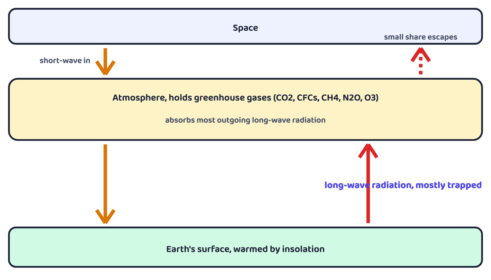
The greenhouse effect is the warming of the atmosphere that happens because greenhouse gases let incoming short-wave solar radiation pass through freely, but absorb the outgoing long-wave radiation from the earth’s surface.
The name comes from an actual greenhouse. Its glass lets in short-wave sunlight easily but is opaque to outgoing long-wave radiation, so heat gets trapped inside and the greenhouse stays warmer than the outside air. A car or bus with its windows shut does exactly the same thing, it feels hotter inside during summer and warmer inside during winter than the air outside.
8.2 Greenhouse gases (GHGs)
Some other gases, like nitric oxide (NO) and carbon monoxide (CO), are not greenhouse gases themselves but react easily with GHGs and affect their concentration in the atmosphere.
Greenhouse gases are the atmospheric gases that absorb outgoing long-wave radiation from the earth’s surface, the primary ones being carbon dioxide, chlorofluorocarbons, methane, nitrous oxide and ozone.
How effective a GHG is depends on three things: how much its concentration has increased, how long it stays in the atmosphere, and the wavelength of radiation it absorbs. CFCs are highly effective. Ozone is very effective at absorbing terrestrial radiation when it sits low in the troposphere (the lowest layer of the atmosphere, where we live), quite different from its protective role higher up in the stratosphere (the layer above the troposphere, which holds the natural ozone layer). The longer a GHG molecule stays in the atmosphere, the longer the earth’s atmospheric system takes to recover from any change it causes.
| Gas | Main source |
|---|---|
| Carbon dioxide (CO2) | Largest share of all GHGs; mainly from burning fossil fuels (oil, gas, coal); forests and oceans are its natural sinks |
| Chlorofluorocarbons (CFCs) | A product of human activity, used in older refrigerants and aerosols |
| Methane (CH4) | Named among the primary GHGs of concern |
| Nitrous oxide (N2O) | Named among the primary GHGs of concern |
| Ozone (O3) | Occurs naturally in the stratosphere; also acts as a GHG when present low in the troposphere |
Deforestation is not usually counted as a separate cause, it works through CO2: forests use CO2 to grow, so cutting them down (a change in land use) leaves more CO2 in the air. CO2 takes 20 to 50 years to adjust between its sources and its sinks, and its concentration is rising at about 0.5% every year. Scientists use the doubling of pre-industrial CO2 level as a standard index in climate models.
8.3 Ozone and the ozone hole
Ozone forms naturally in the stratosphere, where ultraviolet rays convert oxygen into ozone, this stops UV rays from reaching the earth’s surface. CFCs drifting up into the stratosphere destroy this ozone. The largest such depletion happens over Antarctica, and this depleted patch is called the ozone hole. It lets ultraviolet rays pass down through the troposphere instead of being blocked.
The ozone hole is the region of severe depletion of ozone concentration in the stratosphere, most pronounced over Antarctica, caused mainly by CFCs.
8.4 The Kyoto Protocol
International efforts have been made to cut down GHG emissions. The most important of these is the Kyoto Protocol.
It bound 35 industrialised countries to reduce their emissions by the year 2012 to 5% below their 1990 levels.
8.5 Effects of global warming
Once global warming sets in, it is very difficult to reverse. Its effect will not be the same everywhere, but its overall impact on life-supporting systems will be harmful. Rising sea levels, caused by melting glaciers and ice caps plus the thermal expansion of sea water as it warms, could submerge large parts of coastal areas and islands, creating social problems for the people who live there.
8.6 How much has the world actually warmed?
Between the two warming periods above, there was a slight cooling, more noticeable in the Northern Hemisphere. Of the seven warmest years recorded between 1856 and 2000, all seven fell in the last decade of that period, which is where 1998 sits.
- Climate classification has three approaches: empirical (observed data), genetic (causes), applied (specific purpose). Koeppen’s scheme is empirical
- Koeppen used capital letters for 5 groups (A, C, D, E humid; B dry) and small letters for types within them, based on mean temperature and precipitation data
- Group A (tropical) has Af, Am, Aw; Group B (dry) has BSh, BWh, BSk, BWk; Group C (warm temperate) has Cwa, Cs, Cfa, Cfb; Group D (cold snow forest) has Df, Dw; Group E (cold) has ET, EF
- Most of the Indian Peninsula is Am, tropical monsoon climate
- Climate change is proven natural by geology, landforms, glacial sediments, tree rings, historical records, and India’s own wet-dry cycles going back to 8,000 BC
- Causes split into astronomical (sunspots, Milankovitch oscillations) and terrestrial (volcanism, rising greenhouse gases)
- The greenhouse effect: short-wave sunlight passes in freely, long-wave radiation from earth is mostly trapped by greenhouse gases, like heat trapped inside a glasshouse
- Primary greenhouse gases: CO2 (largest share, from fossil fuels), CFCs, methane, nitrous oxide, ozone; CFCs also destroy stratospheric ozone, creating the ozone hole over Antarctica
- Kyoto Protocol (1997, effective 2005, 141 nations) bound 35 industrialised countries to cut emissions 5% below 1990 levels by 2012
- World average temperature is about 14°C; it rose about 0.4°C in each of 1901-44 and 1977-99; 1998 was probably the warmest year of the millennium
- 1 markWhich one of the following is suitable for Koeppen’s “A” type of climate?
(a) High rainfall in all the months(b) Mean monthly temperature of the coldest month more than freezing point(c) Mean monthly temperature of all the months more than 18°C(d) Average temperature for all the months below 10°C - 1 markKoeppen’s system of classification of climates can be termed as:
(a) Applied(b) Systematic(c) Genetic(d) Empirical - 1 markMost of the Indian Peninsula will be grouped, according to Koeppen’s system, under:
(a) “Af”(b) “BSh”(c) “Cfb”(d) “Am” - 1 markWhich one of the following years is supposed to have recorded the warmest temperature the world over?
(a) 1990(b) 1998(c) 1885(d) 1950 - 1 markWhich one of the following groups of four climates represents humid conditions?
(a) A-B-C-E(b) A-C-D-E(c) B-C-D-E(d) A-C-D-F - 1 markThe highest shade temperature ever recorded, 58°C, was at:
(a) Al Aziziyah, Libya(b) Death Valley, USA(c) Sahara, Algeria(d) Thar, India - 1 markThe Kyoto Protocol bound 35 industrialised countries to reduce emissions by 2012 to a level:
(a) 5% below 1990 levels(b) 10% below 2000 levels(c) equal to 1997 levels(d) 15% below 1970 levels - 1 markWhich of the following is NOT a primary greenhouse gas named in the chapter?
(a) Carbon dioxide(b) Methane(c) Nitrogen(d) Ozone
Reason (R): It is based on observed mean annual and mean monthly temperature and precipitation data.
Reason (R): More sunspots are linked by some meteorologists to cooler, wetter weather.
Reason (R): Ozone is very effective at absorbing terrestrial (long-wave) radiation when present in the lower troposphere.
- 1 markWhich two climatic variables did Koeppen use for classifying climate?
- 1 markName the five major climate groups recognised by Koeppen.
- 1 markWhat does the small letter “w” mean in Koeppen’s code?
- 1 markDefine the ITCZ.
- 1 markWhat is permafrost?
- 1 markName the two types of polar climates.
- 1 markWhat is the ozone hole, and where is it most severe?
- 1 markIn which year was the Kyoto Protocol proclaimed?
- 3 marksHow is the “genetic” system of classification different from the “empirical” one?
- 2 marksWhich types of climate have a very low annual range of temperature? Give one example.
- 3 marksWhat type of climatic conditions would prevail if the number of sunspots increases, according to some meteorologists?
- 3 marksDistinguish between the subtropical steppe (BSh) and subtropical desert (BWh) climates.
- 2 marksWhy is the atmosphere heated indirectly by greenhouse gases, rather than by warming the ground directly?
- 3 marksState any three astronomical and terrestrial causes of climate change.
- 3 marksGive any three pieces of evidence that prove climate change is a natural process.
- 2 marksWhy is deforestation linked to rising CO2 levels in the atmosphere?
- 3 marksExplain the Mediterranean climate with its temperature and rainfall characteristics.
- 2 marksWhat evidence does India provide for climate change in the past?
- 5 marksMake a comparison of the climatic conditions between the “A” and “B” types of climate.
- 5 marksWhat type of vegetation would you find in the “C” and “A” type(s) of climate?
- 5 marksWhat do you understand by the term “Greenhouse Gases”? Make a list of greenhouse gases and explain how the greenhouse effect works.
- 5 marksDescribe the five major climate groups of Koeppen’s scheme with their defining criteria and one climate type from each.
- 5 marksDiscuss the astronomical and terrestrial causes of climate change in detail.
- 5 marksWrite an explanatory note on global warming, covering its causes, evidence and effects.
- Collect information about the Kyoto Protocol and its role in tackling global climate change.