and Disasters
- The exact difference between a natural hazard and a natural disaster, and why every hazard does not become a disaster
- How India’s own geography, its plate movement, its coastline, its monsoon, makes it vulnerable to almost every kind of natural disaster
- The causes, the danger zones and the mitigation steps for earthquakes, tsunamis, cyclones, floods, droughts and landslides, one by one
- The three-stage framework the government actually uses to manage a disaster, before, during and after
1What Is a Hazard? What Is a Disaster?
Change never stops. Some changes are slow, like a river carving a valley over thousands of years. Some are sudden, like an earthquake. Nature does not call any of these “good” or “bad”, they just happen. It is only from a human point of view that a change becomes something to fear, because it threatens our lives and property.
A disaster is “an undesirable occurrence resulting from forces that are largely outside human control, strikes quickly with little or no warning, which causes or threatens serious disruption of life and property including death and injury to a large number of people, and requires therefore mobilisation of efforts in excess of that which are normally provided by statutory emergency services.”
Students often use “hazard” and “disaster” as if they mean the same thing. The book treats them as two related but different ideas, and this exact difference is a favourite one-line exam question.
Natural Hazard
- An element in nature (a steep slope, an ocean current, an unstable rock structure) that has the potential to cause harm
- May be permanent or swift, but is not yet a disaster
- Example: a fault line under a city
Natural Disaster
- A hazard that has actually struck: sudden, causes large-scale death and property loss
- People have little or no control over it once it starts
- Example: the earthquake that fault line finally produces
Natural hazards are elements of the natural environment, currents in the oceans, a steep slope, an unstable rock structure, extreme climate, that have the potential to cause harm to people or property.
Not every disaster is natural. Some are entirely man-made: the Bhopal Gas Tragedy and the Chernobyl nuclear disaster happened because of human error, not nature; wars, the release of CFCs (chlorofluorocarbons), and noise, air, water and soil pollution are also directly caused by people. Other disasters are natural but made worse by human activity: deforestation and unscientific land use turn an ordinary rainy season into a flood or a landslide.
Caused directly by people
Bhopal Gas Tragedy, Chernobyl nuclear disaster, wars, CFC and greenhouse gas release, noise/air/water/soil pollution.
Made worse indirectly by people
Landslides and floods due to deforestation, unscientific land use, and construction on fragile slopes.
Human-made disasters can often be prevented with better regulation. Natural disasters cannot be prevented, so the book’s own conclusion is that the only real option for them is mitigation and preparedness, not prevention. Remember this line, it is the chapter’s central argument and shows up in 3 and 5-mark answers.
The world’s understanding of disasters has changed too. Earlier, people simply avoided living in disaster-prone areas, so the damage stayed limited. Today, technology has given humans the power to build almost anywhere, so cities and ports have grown right inside disaster-prone zones, for example the colonisation of river flood plains and port cities like Mumbai and Chennai along the coast. This is exactly why the scale of damage from disasters has increased even though our ability to predict them has also improved.
Every country has the sovereign responsibility to protect its own citizens from natural disasters; priority attention goes to developing, land-locked and small-island states; countries must build up their own disaster-prevention capacity and legislation; and countries must cooperate internationally on technology-sharing, information and resource mobilisation.
1.2 Classification of Natural Disasters
To manage disasters scientifically, they first have to be identified and classified. The book sorts every natural disaster into four broad groups, based on which part of the environment it disturbs.
India experiences almost every disaster on this list, every year, losing thousands of lives and property worth millions of rupees. This is because of its sheer size and diversity, which is why scholars call it the Indian subcontinent and the land of unity in diversity. A vast geographical area, many different climates and cultures, a long colonial past, and a very large population all add up to make India more vulnerable, not less, to natural disasters.
2Earthquakes and Tsunami
2.1 Earthquakes
Earthquakes are the most unpredictable and the most destructive of all natural disasters. The most damaging ones come from tectonic activity, movements deep inside the earth’s crust, while earthquakes caused by volcanic eruptions, rockfalls, landslides, mining subsidence, or the weight of a new dam and reservoir affect a much smaller area.
“Why are there more earthquakes in the Himalayas and the north-east?” Answer with the flowchart above in one line: the Indian Plate is constantly pushing into the Eurasian Plate, and every time the accumulated stress is released, it produces an earthquake.
Some of the most vulnerable states and union territories are Jammu and Kashmir, Ladakh, Himachal Pradesh, Uttarakhand, Sikkim, the Darjeeling area of West Bengal, and all seven north-eastern states. Even parts of the old, stable Peninsular block have had severe earthquakes, Gujarat in 1819, 1956 and 2001, and Maharashtra in 1967 and 1993. Scientists have proposed a new fault-line theory along the Bhima (Krishna) river near Latur and Osmanabad in Maharashtra, suggesting the Indian Plate itself may be breaking there.
After studying more than 1,200 past earthquakes, the National Geophysical Laboratory, the Geological Survey of India, the Department of Meteorology and the National Institute of Disaster Management divided India into five earthquake damage-risk zones, in order: Very High, High, Moderate, Low and Very Low damage risk. The book describes the areas under each of the first three separately, then groups the safest, low-risk parts of the country together, so the table below follows the same grouping.
| Damage-risk zone | Areas included |
|---|---|
| Very high damage risk | North-eastern states; areas north of Darbhanga and Araria (Bihar) along the Indo-Nepal border; Uttarakhand; western Himachal Pradesh (around Dharamshala); Kashmir Valley; the Kuchchh area of Gujarat |
| High damage risk | Remaining parts of Jammu and Kashmir, Ladakh and Himachal Pradesh; northern Punjab; eastern Haryana; Delhi; western Uttar Pradesh; northern Bihar |
| Moderate damage risk | Most of the remaining parts of the country |
| Low to very low damage risk | The stable landmass of the Deccan plateau, considered the safest part of India |
An earthquake in a densely populated area becomes a calamity: it destroys homes, factories, roads and communication links all at once, which is exactly what makes relief work so difficult afterwards. It can also trigger surface fissures through which water and gases escape and flood nearby land, and it can cause landslides that block rivers, sometimes forming new lakes or changing a river’s course entirely.
| On the ground | On man-made structures | On water |
|---|---|---|
| Fissures, settlements sinking, landslides, liquefaction, earth pressure | Cracking, sliding, overturning, buckling, collapse | Unusual waves, hydro-dynamic pressure, tsunami |
Monitor
Set up seismological centres for continuous monitoring, and use GPS (Geographical Positioning System) to track how the tectonic plates are moving.
Map and inform
Prepare a vulnerability map of the country and spread this risk information to people living in unsafe areas.
Build sensibly
Change house types and building designs in vulnerable zones; discourage high-rise buildings and big industries there.
Design for quakes
Make earthquake-resistant design and light building materials compulsory in vulnerable areas.
2.2 Tsunami
A tsunami (also called a harbour wave or seismic sea wave) is a series of high vertical ocean waves caused when an earthquake or volcanic eruption makes the sea floor move abruptly, suddenly displacing a huge mass of water.
A tsunami behaves very differently in the open ocean and near the coast, which is exactly why ships far out at sea barely notice one passing under them.
In the deep ocean
- Wave travels fast
- Wave-length is very long
- Wave-height is small, usually just a metre or two
- A ship only rises and falls slowly, and is barely affected
Near the coast (shallow water)
- Wave slows down
- Wave-length shortens
- Wave-height grows, sometimes to 15 metres or more
- Causes large-scale destruction on land, hence also called a “Shallow Water Wave”
Tsunamis occur most often along the Pacific “Ring of Fire”, off Alaska, Japan, the Philippines, Indonesia, Malaysia, Myanmar, Sri Lanka and India. The most devastating one in living memory struck on 26 December 2004, killing more than 300,000 people across the Indian Ocean rim. India joined the International Tsunami Warning System after this disaster.
A tsunami is not caused by wind or storms, it is caused by a sudden movement of the sea floor, usually from an earthquake. Do not confuse it with a cyclone’s storm surge, which is a completely different mechanism explained in the next section.
3Tropical Cyclones
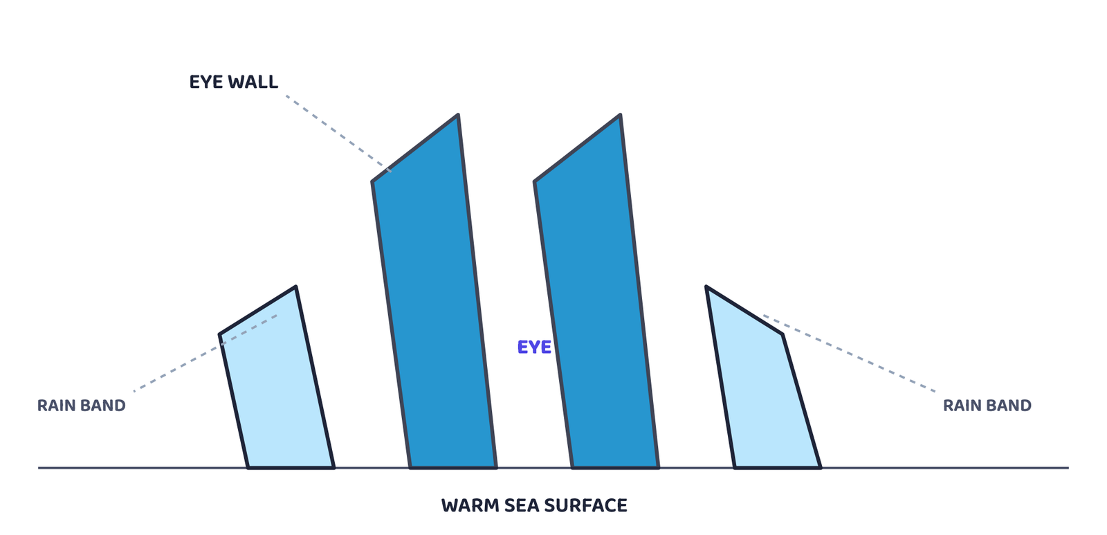
A tropical cyclone is an intense low-pressure system found between 30°N and 30°S, extending 500-1,000 km horizontally and 12-14 km vertically, with very high-velocity winds circling around its centre. It works like a heat engine, powered by the latent heat released when moisture the wind has gathered from the sea condenses.
Warm, moist air
A large and continuous supply of it, releasing enormous latent heat.
Strong Coriolis force
Needed to stop the low pressure at the centre from just filling up. This is exactly why cyclones never form between 0° and 5° latitude, the Coriolis force is too weak there.
An unstable troposphere
Creates the local disturbance around which a cyclone can begin to spin.
No strong vertical wind wedge
Such a wedge would disturb the vertical transport of latent heat and stop the cyclone forming.
| Sea | Usual origin latitude/longitude | Season |
|---|---|---|
| Bay of Bengal | 16°-22°N, west of 92°E, shifting to about 18°N and west of 90°E (near the Sunderban Delta) by July | Mostly October-November; most cyclones overall originate between 10°-15°N during the monsoon |
| Arabian Sea | Also originates around 10°-15°N during the monsoon season | Monsoon season |
A cyclone’s force decreases the further it travels from the sea, since its energy comes from the latent heat of warm, moist sea air. Along the Indian coast, cyclonic storms average 180 km/h. Their most damaging effect is the storm surge, an abnormal rise in sea level caused by very strong winds and low pressure pushing sea water inland along with heavy rain, flooding settlements, farmland and destroying structures.
4Floods
A flood is the inundation of land and human settlements caused by a rise of water in river channels beyond their carrying capacity, spilling over into the surrounding low-lying flood plains.
Unlike most other disasters, floods are slow to build up and occur in well-known regions at a fairly predictable time of year. They can be triggered by heavy surface run-off, a cyclone’s storm surge, unusually long spells of heavy rain, melting snow and ice, poor infiltration into the soil, or extra silt from soil erosion clogging up river channels. Floods are especially frequent and damaging across South, South-east and East Asia, particularly China, India and Bangladesh.
Human activity plays a big part too: deforestation, poor farming practices, disturbing natural drainage, and building homes and farms right on flood plains and river beds all make floods worse. The Rashtriya Barh Ayog (National Flood Commission) has identified 40 million hectares of Indian land as flood-prone.
| Type of flooding | States/regions affected |
|---|---|
| River floods (highest flood-prone states) | Assam, West Bengal, Bihar; also Punjab and Uttar Pradesh |
| Cyclone-driven coastal floods | Odisha, Andhra Pradesh, Tamil Nadu, Gujarat |
| Flash floods (a more recent trend) | Punjab, Rajasthan, northern Gujarat, Haryana |
| Retreating-monsoon floods | Tamil Nadu, during November-January |
The damage floods cause
- Destroys crops, roads, railways and bridges
- Leaves millions homeless, washes away cattle
- Spreads cholera, gastro-enteritis, hepatitis and other water-borne disease
The one benefit floods bring
- Deposits fertile silt on farmland every year
- Best example: Majuli in Assam, the world’s largest riverine island, gets excellent paddy crops after the Brahmaputra floods
- This benefit is tiny compared to the losses
Build barriers
Flood-protection embankments and dams in flood-prone areas.
Plant trees
Afforestation, and discourage heavy construction in the upper reaches of flood-causing rivers.
Clear the channel
Remove human encroachment from river channels and depopulate flood plains, especially in the flash-flood-prone west and north.
Shelter the coast
Cyclone-shelter centres for coastal areas hit by storm surge.
5Droughts
A drought is an extended period of water shortage caused by inadequate rainfall, an unusually high rate of evaporation, and over-use of water stored in reservoirs and under the ground.
Drought is not a single, simple thing, it is a complex mix of rainfall, evaporation, soil moisture, farming practices and socio-economic conditions. The book names four distinct types.
| Type of drought | What causes it |
|---|---|
| Meteorological drought | A long spell of inadequate rainfall, badly distributed over time and place |
| Agricultural (soil-moisture) drought | Soil moisture too low to support crops, leading to crop failure. An area with over 30% of its cropped land under irrigation is excluded from this category |
| Hydrological drought | Water in reservoirs, lakes and aquifers falls below what rainfall can refill |
| Ecological drought | A natural ecosystem’s productivity fails from water shortage, damaging the whole ecosystem |
| Severity | Areas included |
|---|---|
| Extreme drought-affected | Most of Rajasthan west of the Aravali hills (the Marusthali region) and the Kachchh area of Gujarat; Jaisalmer and Barmer districts receive under 90 mm average annual rainfall |
| Severe drought-prone | Eastern Rajasthan, most of Madhya Pradesh, eastern Maharashtra, interior Andhra Pradesh and the Karnataka Plateau, northern interior Tamil Nadu, southern Jharkhand, interior Odisha |
| Moderate drought-affected | Northern Rajasthan, Haryana, southern districts of Uttar Pradesh, remaining Gujarat, Maharashtra except Konkan, Jharkhand, the Coimbatore plateau of Tamil Nadu, interior Karnataka |
The book uses four old Hindi words to describe drought’s cascading effects: akal (shortage of food grain), trinkal (shortage of fodder), jalkal (shortage of water), and when all three strike together, trikal, which is the most devastating stage of all.
Along with these, droughts kill large numbers of cattle, force people and their livestock to migrate, and push people to drink contaminated water, spreading diseases like gastro-enteritis, cholera and hepatitis.
Immediate relief
Safe drinking water, medicine, fodder and water for cattle, and shifting people and livestock to safer places.
Find more water
Identify groundwater and aquifers, transfer river water from surplus to deficit areas, plan for inter-linking of rivers, build reservoirs and dams.
Use technology
Remote sensing and satellite imagery to find river-basins worth linking and groundwater worth tapping.
Plan for the long term
Spread knowledge of drought-resistant crops, train farmers to grow them, and promote rooftop rainwater harvesting.
6Landslides
A landslide is the rapid downslope sliding of a large mass of rock and debris under gravity, along a plane of weakness.
Landslides are much more localised than earthquakes or cyclones, which are controlled by large, regional factors. A landslide instead depends on very local conditions, geology, slope, land-use, vegetation cover and human activity right at that one spot, which is exactly why gathering information about them is both difficult and expensive.
| Vulnerability zone | Areas included |
|---|---|
| Very high vulnerability | Young, unstable Himalayan mountains and the Andaman and Nicobar Islands; high-rainfall, steep-slope areas of the Western Ghats and the Nilgiris; the north-eastern region; areas that shake often from earthquakes; areas of heavy road and dam construction |
| High vulnerability | Almost the same conditions as above, at slightly lower intensity: all Himalayan states and the north-eastern states, except the plains of Assam |
| Moderate to low vulnerability | Low-rainfall Trans-Himalayan Ladakh and Spiti (Himachal Pradesh); the stable, low-rainfall Aravali hills; rain-shadow parts of the Western and Eastern Ghats; the Deccan plateau (occasional landslides only) |
| Mining and subsidence landslides | Jharkhand, Odisha, Chhattisgarh, Madhya Pradesh, Maharashtra, Andhra Pradesh, Karnataka, Tamil Nadu, Goa, Kerala |
| Safe from landslides | Rajasthan, Haryana, Uttar Pradesh, Bihar, most of West Bengal and Assam, and the coastal plains of the southern states |
Even though the direct area affected is small, a landslide’s effects can spread far: it can block roads and railway lines, and it can dam or divert a river, causing floods somewhere else entirely. It also makes travel and trade in the area riskier and more expensive, which slows down development.
Restrict construction
Limit roads, dams and other big projects in the high-vulnerability zones.
Farm carefully
Keep agriculture to valleys and gently sloping land; control the growth of large settlements in risky zones.
Add cover
Large-scale afforestation, and bunds to slow down the flow of water.
Change farming methods
Encourage terrace farming over jhumming (slash-and-burn or shifting cultivation) in the north-eastern hill states.
7Disaster Management
Cyclones are actually easier to manage than earthquakes, tsunamis or volcanic eruptions, because modern tracking can predict their time, place, direction and intensity reasonably well. This lets governments build cyclone shelters, embankments, dykes and reservoirs, and plant trees to slow down the wind, in advance. Even so, countries like India, Bangladesh and Myanmar keep losing lives because so many people live right on the vulnerable coast.
This Bill defines a disaster as “a catastrophe, mishap, calamity or grave occurrence affecting any area, arising from natural or man-made causes, or by accident or negligence, which results in substantial loss of life or human suffering, or damage to and destruction of environment, and is of such nature or magnitude as to be beyond the coping capacity of the community of the affected area.”
Every disaster, whatever its cause, is handled in three stages.
The Disaster Management Bill, 2005 and the founding of the National Institute of Disaster Management are the Government of India’s two clearest steps in this direction.
Disasters can be natural or man-made, but not every hazard turns into a disaster, and since natural disasters cannot really be prevented, the only real option is mitigation and preparedness.
the chapter’s own conclusion
- A hazard is a potential for harm; a disaster is that harm actually happening at a large, uncontrollable scale
- India is highly disaster-prone because of its huge size, its diverse climate, and its large, unevenly protected population
- Natural disasters fall into 4 groups: Atmospheric, Terrestrial, Aquatic and Biological
- Earthquakes come from the Indian Plate pushing into the Eurasian Plate; India has 5 damage-risk zones, from very high to very low
- A tsunami is small in the deep ocean and huge near the coast, the exact opposite of what most people expect
- A tropical cyclone needs warm moist air, strong Coriolis force, an unstable troposphere and no vertical wind wedge, and never forms within 5° of the equator
- Floods are the most predictable disaster, yet still the most damaging in Assam, West Bengal and Bihar every year
- Drought has 4 types (meteorological, agricultural, hydrological, ecological) and hits hardest in western Rajasthan and Kachchh
- Landslides are controlled by local, not regional, factors, which makes them the hardest hazard to monitor
- Disaster management always has 3 stages: pre-disaster planning, during-disaster rescue and relief, and post-disaster rehabilitation
- 1 markDefine a natural hazard.
- 1 markName the four categories used to classify natural disasters.
- 1 markWhat is a storm surge?
- 1 markName the commission that identified 40 million hectares of India as flood-prone.
- 1 markWhat do the terms akal, trinkal and jalkal mean?
- 1 markName India’s largest riverine island and the river it lies on.
- 1 markWhat is jhumming, and where is it practised?
- 2 marksWhen can a hazard become a disaster?
- 2 marksWhy are there more earthquakes in the Himalayas and in north-east India?
- 2 marksWhat are the basic requirements for the formation of a tropical cyclone?
- 2 marksHow are floods in eastern India different from floods in western India?
- 2 marksWhy are droughts more frequent in central and western India?
- 3 marksDistinguish between a natural hazard and a natural disaster with one example each.
- 3 marksWhy does a tsunami cause little damage in the open ocean but huge damage near the coast?
- 3 marksList the four types of drought and how each one is caused.
- 5 marksIdentify the landslide-prone regions of India and suggest measures to reduce the disasters they cause.
- 5 marksWhat is vulnerability? Divide India into drought-vulnerability zones and suggest mitigation measures for each.
- 5 marksWhen can developmental activity itself become the cause of a disaster? Explain with examples from this chapter.
- 5 marksDescribe India’s five earthquake damage-risk zones and the steps taken to reduce earthquake damage.
- 5 marksExplain the three stages of disaster management with one example of what is done in each stage.
- 5 marksWrite a short note on the Bhuj and Latur earthquakes and what they revealed about India’s “stable” Peninsular block.
- 1 markWhich one of the following states of India experiences floods most frequently?
(a) Bihar(b) West Bengal(c) Assam(d) Uttar Pradesh - 1 markIn which district of Uttarakhand did the Malpa Landslide disaster take place?
(a) Bageshwar(b) Champawat(c) Almora(d) Pithoragarh - 1 markWhich one of the following states receives floods in the winter months?
(a) Assam(b) West Bengal(c) Kerala(d) Tamil Nadu - 1 markMajuli, the world’s largest riverine island, is situated in which river?
(a) Ganga(b) Brahmaputra(c) Godavari(d) Indus - 1 markUnder which type of natural hazard do blizzards fall?
(a) Atmospheric(b) Aquatic(c) Terrestrial(d) Biological - 1 markA tropical cyclone cannot form between 0° and 5° latitude because:
(a) the sea is too cold there(b) the Coriolis force is too weak there(c) there is no moisture there(d) the troposphere is too stable there - 1 markThe Disaster Management Bill that defines “disaster” in India was passed in:
(a) 1994(b) 1999(c) 2005(d) 2010 - 1 markThe Yokohama Strategy and Plan of Action for a Safer World was adopted at a conference held in:
(a) 1989(b) 1993(c) May 1994(d) 2000
- 1 mark
Assertion (A): Ships far out at sea are barely affected by a tsunami.
Reason (R): In deep water, a tsunami has a very long wave-length and a very small wave-height, so it only raises a ship by a metre or two. - 1 mark
Assertion (A): The Deccan plateau is considered one of the safest parts of India from earthquakes.
Reason (R): It is a stable landmass that falls in the low to very-low earthquake damage-risk zone. - 1 mark
Assertion (A): Every natural hazard eventually becomes a natural disaster.
Reason (R): A disaster only occurs when a hazard actually strikes and causes damage beyond a community’s coping capacity.