- How scientists study the earth’s deep interior even though no one has ever reached it
- Why earthquakes happen, and how P-waves, S-waves and surface waves are different
- What the “shadow zone” is, and what it proves about the earth’s core
- How an earthquake’s magnitude and intensity are measured
- The layered structure of the earth, from the crust down to the inner core
- The different kinds of volcanoes, and the landforms magma builds underground
P-waveS-waveshadow zoneRichter scaleMercalli scale
asthenospherelithosphereMoho discontinuitymagmalava
calderabatholithdykeDeccan Traps
1Sources of Information About the Interior
The earth’s radius is about 6,378 km, but no one has ever reached its centre or
collected a sample from deep inside it. Almost everything we know about the
earth’s interior comes from indirect evidence, estimates and inference, with
only a small part based on direct observation.
A source of information is called direct when it comes from material
or a place scientists can actually reach and examine, and indirect
when it is worked out from the properties of matter without reaching it.
1.1 Direct sources
Mining and drilling
Surface rock and mined rock are the most easily available solid material. Gold
mines in South Africa go 3-4 km deep; beyond this it is too hot to work. Scientific
projects such as the Deep Ocean Drilling Project and the Integrated Ocean Drilling
Project go deeper still. The deepest drill so far, at Kola in the Arctic Ocean,
has reached 12 km.
Volcanic eruption
When magma is thrown onto the surface during an eruption, it becomes available
for laboratory analysis straightaway. The one difficulty is that the exact depth
the magma came from is hard to work out.
1.2 Indirect sources
What mining tells us
- Temperature rises with depth
- Pressure rises with depth
- Density of material rises with depth
- Knowing the earth’s total thickness, these rates let scientists estimate
values at any depth
Other indirect clues
- Meteors: similar material and structure to the earth, but NOT
actually from earth’s interior - Gravitation: gravity varies with latitude and mass distribution
- Magnetic surveys: show how magnetic material is distributed in the crust
- Seismic activity: the single most important indirect source
Gravity anomaly is the difference between the gravity value actually
observed at a place and the value expected there. It tells scientists how mass
is distributed within the earth’s crust.
Gravity itself is not the same everywhere on earth. It is greater near the
poles and less at the equator, simply because the equator is farther from the
earth’s centre than the poles are.
2Earthquakes
An earthquake, in simple words, is the shaking of the earth. It is a
natural event caused by the sudden release of energy, which generates waves
that travel out in all directions.
2.1 Why does the earth shake?
A fault is a sharp break in the crustal rocks, along which rocks on
either side tend to move in opposite directions.
The point inside the earth where energy is released is the focus,
also called the hypocentre. The epicentre is the point on the
surface nearest to the focus, directly above it, the first point to feel
the waves.
3Earthquake Waves
All natural earthquakes occur within the lithosphere, the portion of the
earth up to about 200 km deep. An instrument called a seismograph
records the waves as they reach the surface. Earthquake waves are of two
basic kinds: body waves, which travel through the body of the earth, and
surface waves, which travel only along the surface.
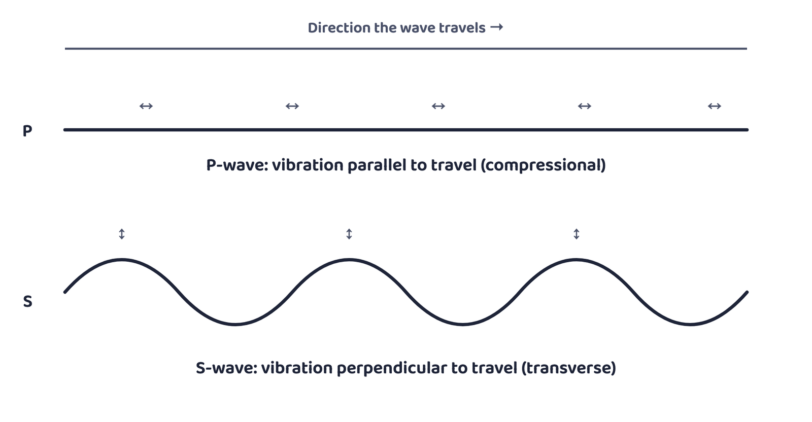
with the direction of travel. S-waves make the material move up and down, at right
angles to the direction of travel.
| Property | P-waves (Primary) | S-waves (Secondary) |
|---|---|---|
| Speed | Faster, first to arrive | Slower, arrives with a time lag |
| Vibration direction | Parallel to travel (compressional) | Perpendicular to travel, in the vertical plane (transverse) |
| Travels through | Solids, liquids AND gases | Only solids |
| Similar to | Sound waves | — |
| Effect on material | Stretching and squeezing (density changes) | Troughs and crests |
Students often confuse “surface waves” with “S-waves” because the names sound
alike. Surface waves are a separate, third type, generated only when body waves
reach the surface and interact with surface rocks. They are the most destructive
of all three, causing structures to collapse.
4The Shadow Zone
The shadow zone is a belt on the earth’s surface where an earthquake’s
waves are not recorded by any seismograph.
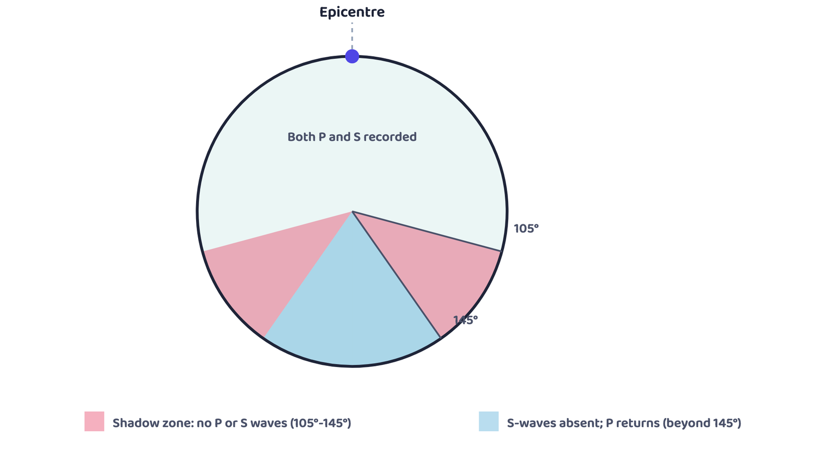
no seismograph records either wave. Beyond 145°, P-waves reappear, but S-waves stay
absent everywhere beyond 105°, proof that the outer core is liquid.
- Seismographs within 105° of the epicentre record both P-waves and S-waves.
- Seismographs beyond 145° record only P-waves, never S-waves.
- The band between 105° and 145° is the shadow zone for both wave types.
- The S-wave shadow zone is far bigger than the P-wave shadow zone: the P-wave
shadow is only that 105°-145° band, but S-waves never arrive anywhere beyond 105°
a zone covering just over 40% of the earth’s surface.
“Why does the shadow zone prove the outer core is liquid?” is a favourite 3-mark
question. The answer in one line: S-waves cannot travel through liquids, so the
liquid outer core blocks them completely, while P-waves (which can travel through
liquids too, just more slowly) bend around it and reappear beyond 145°.
5Types, Measurement and Effects of Earthquakes
| Scale | Measures | Named after | Range |
|---|---|---|---|
| Richter scale | Magnitude, the energy released | Charles Richter | 0 to 10 |
| Mercalli scale | Intensity, the visible damage caused | Giuseppe Mercalli (Italian seismologist) | 1 to 12 |
5.1 Effects of an earthquake
Mainly affect landforms
- Ground shaking
- Differential ground settlement
- Land and mud slides
- Soil liquefaction
- Ground lurching
- Avalanches
Mainly threaten life and property
- Ground displacement
- Floods from dam and levee failure
- Fires
- Structural collapse
- Falling objects
- Tsunami
A tsunami is not an earthquake in itself. It is a set of waves
generated by a tremor. It occurs only if the earthquake’s epicentre lies
below the ocean and the magnitude is high enough.
6Structure of the Earth
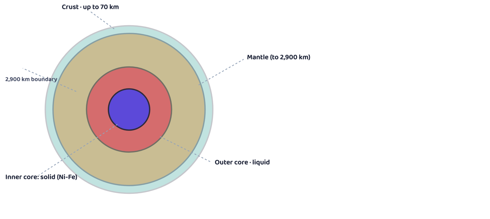
uppermost mantle together form the lithosphere; the upper mantle’s weak asthenosphere
is the main source of magma.
| Layer | Extent | State | Key facts |
|---|---|---|---|
| Crust | Surface to Moho discontinuity | Solid, brittle | Oceanic crust ~5 km; continental crust ~30 km; up to ~70 km under the Himalaya |
| Mantle | Moho to 2,900 km depth | Asthenosphere (upper) is weak; lower mantle is solid |
Asthenosphere extends to ~400 km, the main source of magma |
| Outer core | 2,900 km to inner core boundary | Liquid | Blocks S-waves completely |
| Inner core | Innermost part, to earth’s centre | Solid | Made mostly of nickel and iron, the “NiFe” layer |
The asthenosphere is the weak upper portion of the mantle (extending
to about 400 km), and the main source of the magma that reaches the surface
during volcanic eruptions.
The lithosphere is the crust plus the uppermost part of the mantle
together, ranging from about 10 to 200 km thick. All natural earthquakes occur
within it.
7Volcanoes and Volcanic Landforms
A volcano is a place where gases, ash and/or molten rock (lava)
escape to the ground. It is called active if this material is being
released, or was released in the recent past.
While the material is still inside the earth, in the upper mantle, it is
called magma. Once it starts moving towards the crust, or reaches the
surface, it is called lava.
7.1 Types of volcanoes
| Type | Lava / eruption | Shape | Example |
|---|---|---|---|
| Shield | Very fluid basalt lava | Largest of all volcanoes, gentle slope | Hawaiian volcanoes |
| Composite | Cooler, more viscous lava, often explosive | Layers of lava and pyroclastic material build a steep cone | — |
| Caldera | Extremely explosive | Collapses inward instead of building height | — |
| Flood basalt province | Highly fluid, flows very long distances | Thousands of sq km of thick lava sheets | Deccan Traps (Maharashtra plateau, India) |
| Mid-ocean ridge | Frequent eruptions along a ridge system | A ridge over 70,000 km long, through every ocean basin | — |
“Which volcanic eruption formed the Deccan Traps?” is asked almost every year.
The answer is flood basalt, not shield, even though both involve fluid
basalt lava. Flood basalt is defined by covering huge areas over long distances;
shield volcanoes build a single large dome.
7.2 Volcanic landforms: Intrusive forms
Lava that cools while still inside the crust forms plutonic (intrusive)
rocks, taking on different shapes depending on where and how it cools.
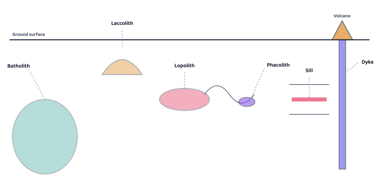
largest and deepest; a laccolith pushes up a dome near the surface; a lopolith sags into
a saucer shape; a phacolith sits in a fold; sills run between rock layers; a dyke cuts
straight up through them and often feeds a volcano at the surface.
| Landform | Shape / description |
|---|---|
| Batholith | A very large, deep dome of cooled magma; appears at the surface only after erosion strips away the rock above it |
| Laccolith | A dome-shaped body with a flat base, fed by a pipe-like conduit; found at shallower depth than a batholith |
| Lopolith | A saucer-shaped body, concave (sagging) towards the sky |
| Phacolith | A wavy mass of intrusive rock at the base of a syncline or the top of an anticline in folded rock |
| Sill / Sheet | A near-horizontal intrusive body between rock layers; thin ones are sheets, thick ones are sills |
| Dyke | Lava that solidifies in a nearly vertical crack, forming a wall-like structure; common in western Maharashtra and feeds Deccan Trap eruptions |
Every layer of the earth we can name, crust, mantle, core, was worked out
without anyone ever going there, purely from how earthquake waves behave.
The single idea to carry out of this chapter
- Direct sources: mining, drilling projects, volcanic eruption. Indirect sources: temperature/pressure/density with depth, meteors, gravity, magnetism, and seismic activity (the most important one)
- An earthquake is caused by sudden release of energy along a fault; focus is underground, epicentre is on the surface directly above it
- P-waves: fastest, through solid/liquid/gas, parallel vibration. S-waves: slower, only through solids, perpendicular vibration. Surface waves: most destructive
- Shadow zone 105°-145° from epicentre: no waves at all. Beyond 105°, S-waves never arrive anywhere; proof the outer core is liquid
- Richter scale measures magnitude (0-10); Mercalli scale measures intensity from damage (1-12)
- Crust (solid) → Mantle to 2,900 km (asthenosphere is the weak, magma-source part) → Outer core (liquid) → Inner core (solid, Ni-Fe)
- Volcano types: Shield (gentle, basalt), Composite (steep, explosive), Caldera (most explosive, collapses), Flood basalt (Deccan Traps), Mid-ocean ridge
- Intrusive landforms: Batholith, Laccolith, Lopolith, Phacolith, Sill, Dyke; all lava that cooled underground instead of at the surface
- Can I list three direct and three indirect sources of information about the interior?
- Can I explain, in my own words, why a fault produces an earthquake?
- Can I say which wave cannot pass through liquids, and why that matters?
- Can I explain what the shadow zone proves about the earth’s core?
- Can I draw and label the earth’s four main layers with their depths?
- Can I name all five types of volcanoes and one fact about each?
- Can I name all six intrusive landforms and describe their shapes?
- 1 markDefine a fault.
- 1 markWhat is meant by the epicentre of an earthquake?
- 1 markName the two main layers that lie between the crust and the core.
- 1 markWhat is magma called once it reaches the earth’s surface?
- 1 markName the scale used to measure the magnitude of an earthquake.
- 1 markWhat is a caldera?
- 3 marksWhat are body waves?
- 3 marksName the direct sources of information about the interior of the earth.
- 3 marksWhy do earthquake waves develop a shadow zone?
- 3 marksBriefly explain the indirect sources of information about the interior of the earth, other than seismic activity.
- 3 marksDifferentiate between magma and lava.
- 3 marksWhat is a gravity anomaly, and what does it tell scientists?
- 3 marksWhy are Hawaiian volcanoes classified as shield volcanoes?
- 5 marksWhat are the effects of the propagation of earthquake waves on the rock mass through which they travel?
- 5 marksWhat do you understand by intrusive forms? Briefly describe the various intrusive forms.
- 5 marksDescribe the structure of the earth’s interior with reference to the crust, mantle and core.
- 1 markWhich one of the following earthquake waves is more destructive?
(a) P-waves(b) S-waves(c) Surface waves(d) None of the above - 1 markWhich one of the following is a direct source of information about the interior of the earth?
(a) Earthquake waves(b) Volcanoes(c) Gravitational force(d) Earth magnetism - 1 markWhich type of volcanic eruption caused the Deccan Trap formations?
(a) Shield(b) Flood(c) Composite(d) Caldera - 1 markWhich one of the following describes the lithosphere?
(a) Upper and lower mantle(b) Crust and upper mantle(c) Crust and core(d) Mantle and core - 1 markThe shadow zone for S-waves proves that the outer core is:
(a) Solid(b) Liquid(c) Gaseous(d) Plasma - 1 markThe core-mantle boundary lies at a depth of:
(a) 400 km(b) 900 km(c) 2,900 km(d) 6,378 km - 1 markWhich scale measures an earthquake’s intensity, based on visible damage?
(a) Richter(b) Mercalli(c) Kelvin(d) Beaufort - 1 markThe weak upper-mantle zone that is the main source of magma is called the:
(a) Lithosphere(b) Crust(c) Asthenosphere(d) Core - 1 markA collapsed volcanic depression, formed by an extremely explosive eruption, is called a:
(a) Caldera(b) Sill(c) Dyke(d) Batholith - 1 markWhich intrusive landform is a wall-like structure formed when lava solidifies in a nearly vertical crack?
(a) Sill(b) Dyke(c) Lopolith(d) Phacolith - 1 markThe magnitude of an earthquake on the Richter scale ranges from:
(a) 0-10(b) 1-12(c) 0-100(d) 1-10 - 1 markThe mid-ocean ridge system extends for more than:
(a) 7,000 km(b) 70,000 km(c) 700 km(d) 7,00,000 km
- 1 mark
Assertion (A): The oceanic crust is thinner than the continental crust.
Reason (R): Oceanic crust is on average about 5 km thick, while continental crust is on average about 30 km thick. - 1 mark
Assertion (A): The shadow zone between 105° and 145° from the epicentre records neither P-waves nor S-waves.
Reason (R): The Mercalli scale measures the intensity of an earthquake based on the energy released.