1 Earth’s Interior and Plate Tectonics
The Earth’s surface never stays the same. Mountains rise, valleys deepen, coastlines shift, all because of forces working inside the Earth and forces working on its surface. The most important idea that explains this is called plate tectonics.
A landform is a natural feature on the Earth’s surface, formed by weathering, erosion, deposition, and the movement of the Earth’s crust. Mountains, valleys, plateaus, plains, deserts and coasts are all landforms.
Plate tectonics, a theory given by W.J. Morgan, says that the outermost layer of the Earth is not one single piece. It is broken into several large and small pieces called tectonic plates, which move slowly over the layer beneath them.
A tectonic plate is a massive slab of solid rock that moves a few centimetres every year. Plates are of three kinds: continental plates (carry continents), oceanic plates (carry ocean floors), and mixed plates (carry both).
| Type of plate | What it carries |
|---|---|
| Continental plate | Continents (land only) |
| Oceanic plate | Ocean floor only |
| Mixed plate | Both continents and ocean floor together |
1.1 What is inside the Earth?
The Earth is made up of three main layers: the crust (the thin outer layer we live on), the mantle (thick and very hot), and the core (the innermost layer, extremely hot and heavy). The crust together with the upper part of the mantle forms the lithosphere, and this is what is actually broken into tectonic plates.
The lithosphere is the rigid outer layer of the Earth, made of the crust and the uppermost part of the mantle. It is broken into the different tectonic plates.
The asthenosphere is the hot, semi-molten layer just below the lithosphere. It is soft enough to flow very slowly, which is what lets the rigid plates above it slide.
| Layer | Approximate thickness | What it is like |
|---|---|---|
| Crust | 30–40 km under continents, 5–7 km under oceans | Thin, rigid outer skin we live on |
| Lithosphere | About 100 km | Crust + uppermost mantle; rigid, broken into plates |
| Asthenosphere | About 200 km | Hot, semi-molten layer; lets plates slide over it |
| Mantle | About 2,900 km | Mostly solid, very hot, between crust and outer core |
| Outer core | About 2,200 km | Fluid layer, mostly iron and nickel |
| Inner core | About 1,250 km | Solid, hot, spinning metal ball; the densest part of the Earth |
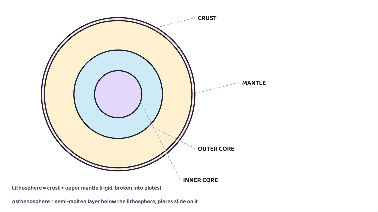
Heat from the Earth’s core makes molten material in the mantle rise while cooler material sinks. This constant movement, called a convection current, is what pushes and pulls the tectonic plates above it. The three ways heat moves inside the Earth are called advection, convection and conduction.
1.2 Plate boundaries
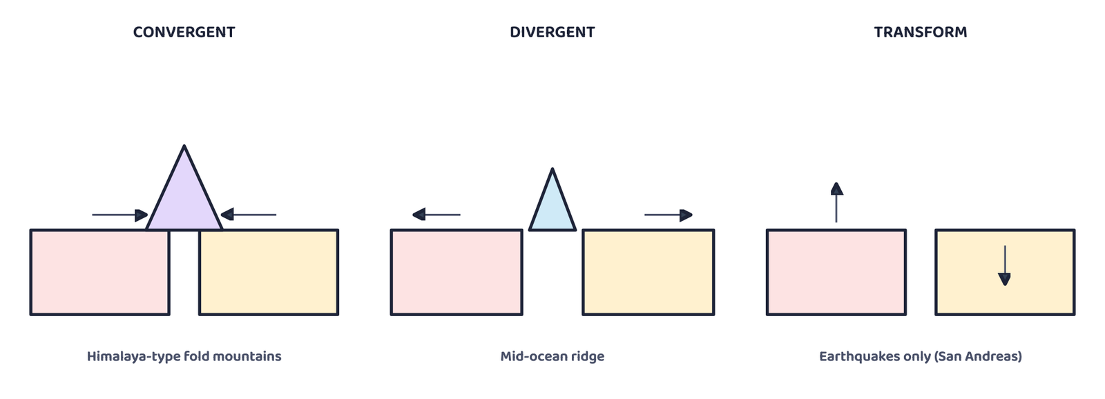
A plate boundary is the edge where two tectonic plates meet. There are three main types: convergent, divergent and transform.
| Type of boundary | How the plates move | What it creates | Example |
|---|---|---|---|
| Convergent | Move towards each other | Continental + continental → fold mountains. Oceanic + continental → the oceanic plate sinks (subducts), causing volcanoes and earthquakes | The Himalaya |
| Divergent | Move away from each other | Magma rises from below and forms new crust, creating mid-ocean ridges | The Mid-Atlantic Ridge |
| Transform | Slide past each other; no crust is made or destroyed | Mainly causes earthquakes, no mountains or ridges | The San Andreas Fault, USA |
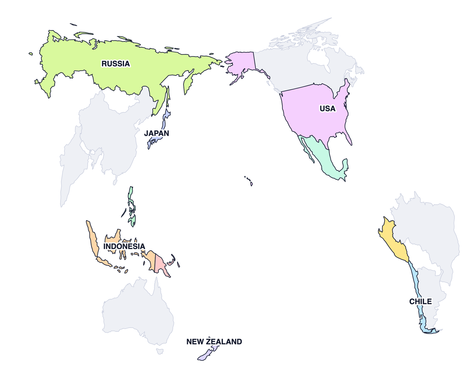
Seven major tectonic plates cover the Earth’s surface:
Most earthquakes and volcanoes happen along plate boundaries, especially around the Pacific Ocean. This belt is called the Ring of Fire.
India has experienced major earthquakes, such as the 2001 Gujarat (Bhuj) earthquake, which caused huge loss of life and property. Questions on “why India is earthquake-prone” usually want the answer linked to the Indian Plate pushing into the Eurasian Plate along the Himalayan region.
Ancient India already had a science of earthquakes. Earthquakes were called bhūkampa (shaking of the Earth). In the Bṛihatsaṁhitā, the scholar Varāhamihira linked earthquake warnings to four forces: Vāyu (wind), Agni (fire), Indra (thunder) and Varuṇa (water).
India has its own mud volcano at Baratang Island in the Andaman and Nicobar Islands. Instead of fiery lava, mud bubbles out here because of underground gases and pressure.
2 Weathering and Erosion
Once landforms are pushed up by plate movement, two slower processes start wearing them down: weathering and erosion. Together they carve mountains into valleys, cut caves and cliffs, and build the plains we farm on.
Weathering is the breaking down of rocks on the Earth’s surface into smaller pieces. It does not involve any movement of the broken material, only the breaking.
| Type of weathering | What causes it |
|---|---|
| Physical weathering | Temperature changes, frost, or wind physically break the rock apart |
| Chemical weathering | Minerals in the rock react with water, air, or acids and change into new substances |
| Biological weathering | Plants, animals or micro-organisms break the rock, e.g. roots growing into cracks and splitting them apart |
Erosion is the wearing away of soil, rocks and other surface material, and its movement from one place to another by water, wind, ice or waves.
Weathering
- Breaks rock into smaller pieces
- No movement of material
- Happens in one place
Erosion
- Wears away and carries material
- Material moves to another place
- Needs an agent: water, wind, ice or waves
| Type of erosion | Main agent |
|---|---|
| Water erosion | Rivers, rain, or ocean waves |
| Wind erosion | Wind, common in dry and sandy areas |
| Glacial erosion | Moving ice, which scrapes and carries rocks |
| Coastal erosion | Sea waves wearing away the land along the shore |
Farmers
Erosion removes fertile topsoil, lowering crop yields.
Riverside and coastal people
Erosion can wash away land, houses and roads.
Construction and mining
Erosion destabilises land, creating safety risks.
Tourism and fishing
Beaches, rivers and fertile land can be destroyed.
The ancient Sindhu-Sarasvatī civilisation already used careful techniques to fight soil erosion and conserve water, recorded in texts like the Vedas, Kṛiṣhiparāśhara and Kauṭilya’s Arthaśhāstra. The Zabo system of Nagaland still uses earthen bunds and check dams for the same purpose today.
| Technique | What it does |
|---|---|
| Contouring | Trenches dug along the contour lines of a hillside to slow, hold and soak up rainwater |
| Bunding | Earthen embankments along contour lines that slow surface run-off and increase water soaking into the soil |
| Terracing | A series of level, step-like platforms cut into a hillside to stop soil from being washed away |
3 Agents of Gradation
Agents of gradation are natural forces that wear down, transport and deposit material on the Earth’s surface, gradually levelling it. The five main agents are running water, glaciers, wind, waves and groundwater.
Running water
Erodes rock and soil to form valleys and plains.
Glaciers
Scrape and carry huge amounts of material, carving U-shaped valleys.
Wind
Shapes deserts by eroding and depositing sand.
Waves
Erode coastlines to form cliffs, beaches and bays.
Groundwater
Dissolves rocks like limestone, creating caves and sinkholes.
Landforms have shaped human history. The fertile plains of the Ganga, Nile, Brahmaputra and Indus gave rise to early farming societies and cities. The Himalaya protected India from invasions while still allowing trade through passes like the Khyber Pass, and the Thar desert encouraged trade routes such as the Silk Route.
4 Landforms Made by Running Water
A river changes character as it flows from the mountains to the sea, and it builds a different set of landforms at each stage of its journey.
| Course of the river | Landforms formed |
|---|---|
| Upper course (steep, near the source) | V-shaped valleys, waterfalls, rapids |
| Middle course (river loses energy) | Meanders, oxbow lakes, floodplains |
| Lower course (river slows down) | Deltas, levees, alluvial fans |
4.1 Waterfall
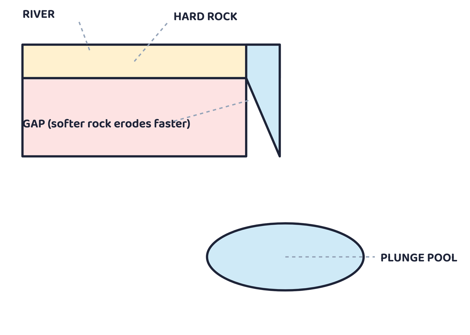
A waterfall is a landform where a river drops over a steep cliff. It forms where a layer of hard rock resists erosion while the softer rock below wears away faster, creating a sudden drop. Waterfalls attract tourists and are also used for hydroelectric power.
4.2 Meander
A meander is a winding bend in the middle or lower course of a river, formed because the river erodes its outer bank and deposits sediment on its inner bank. The fertile soil along a meander is ideal for farming, and settlements often grow on its gentle slopes.
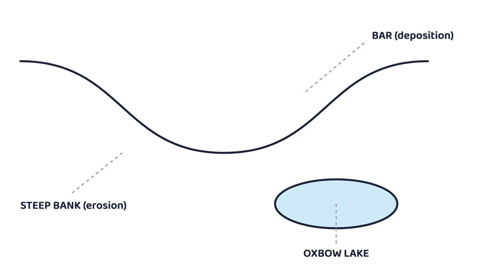
The Grand Anicut, or Kallanai, in Tamil Nadu is a well-known example of a river being used for irrigation.
4.3 Delta
A delta is a fan-shaped or triangular landform at the mouth of a river, formed where the river deposits the sediment it has carried before entering a sea, ocean or lake. Deltas have rich alluvial soil, ideal for crops like rice and jute, but they are also prone to flooding.
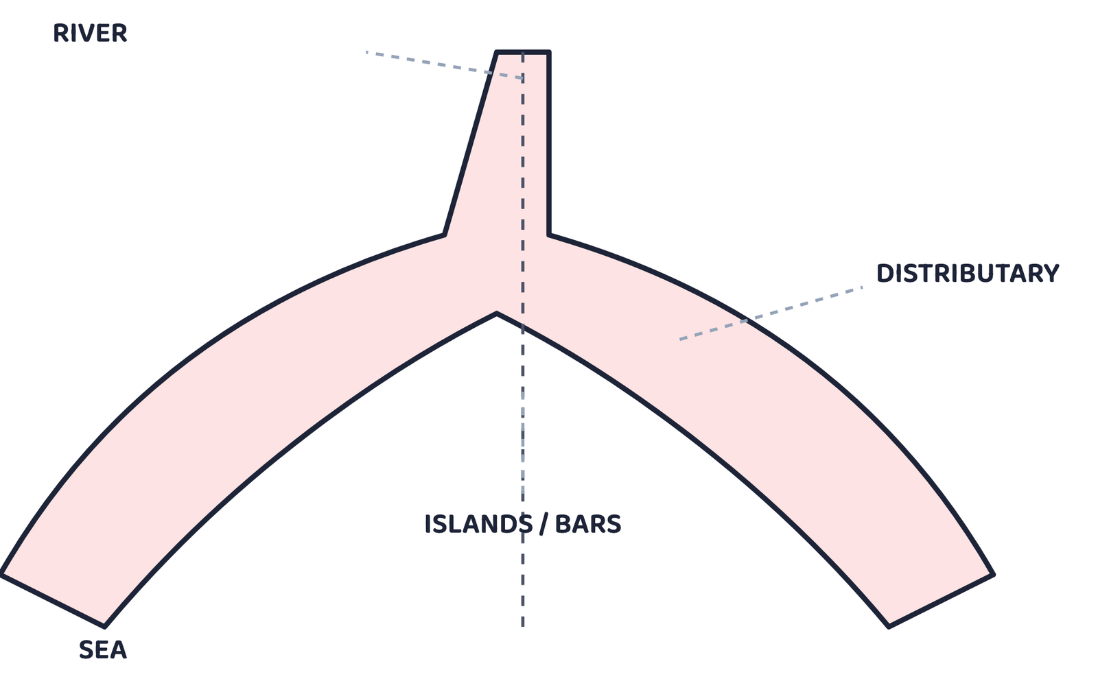
The Sundarbans, formed by the Ganga-Brahmaputra system, is the world’s largest delta and a popular destination for tourists.
5 Landforms Made by Waves and Currents
Along a coast, waves and currents are always moving. They build up beaches in some places and cut away cliffs in others.
A beach is a landform of sand, pebbles or rocks along a shoreline, created when waves deposit sediment. Beaches are popular for tourism and fishing, and they act as a natural barrier against strong waves and coastal erosion.
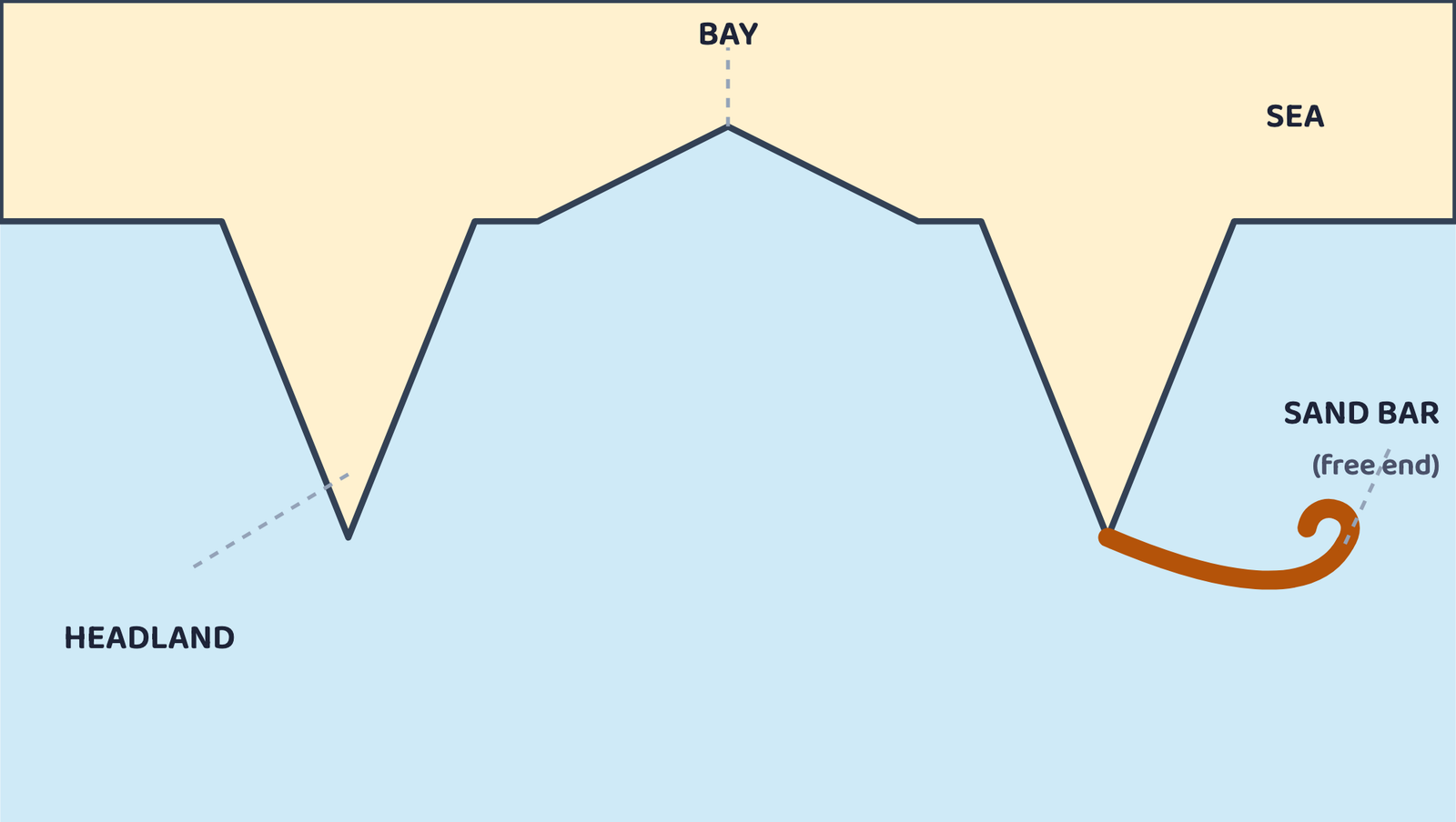
Where waves attack rocky coasts instead of depositing sand, they cut a different set of landforms.
| Coastal erosion landform | How it forms |
|---|---|
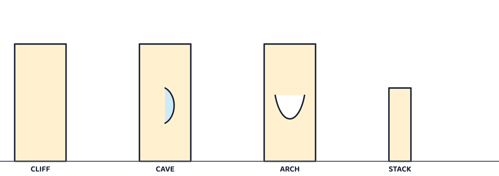
| Cliff | A steep rock face, formed as waves undercut the base of the coast |
| Wave-cut platform | A flat rocky area left behind as a cliff retreats |
| Cave | Formed when waves erode a weak part of the rock |
| Arch | Formed when caves on both sides of a headland meet |
| Stack | An isolated pillar of rock left standing after an arch collapses |
6 Landforms Made by Glaciers
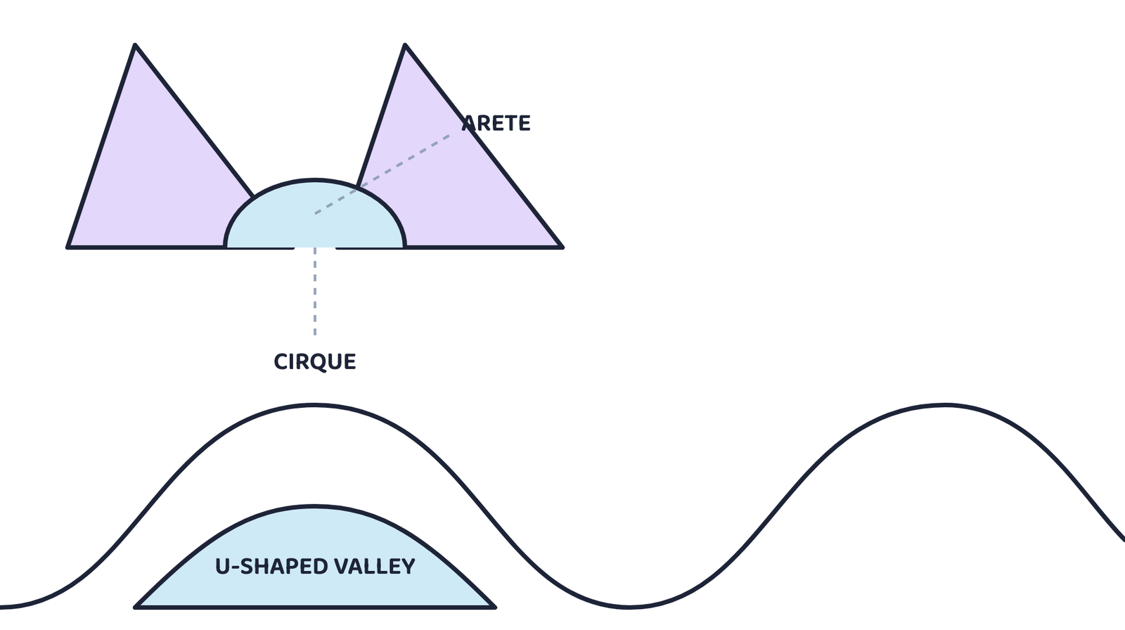
In cold mountain regions, huge rivers of slow-moving ice, called glaciers, carve out their own set of landforms.
| Glacial landform | How it forms |
|---|---|
| U-shaped valley | A glacier widens and deepens an old river valley into a U-shape |
| Cirque | A bowl-shaped hollow carved at the head of a glacier |
| Arete | A sharp, narrow ridge left between two glacial valleys |
| Hanging valley | Forms where a smaller glacier joins a larger one at a height |
| Fjord | A deep, narrow inlet formed when the sea floods a glacial valley |
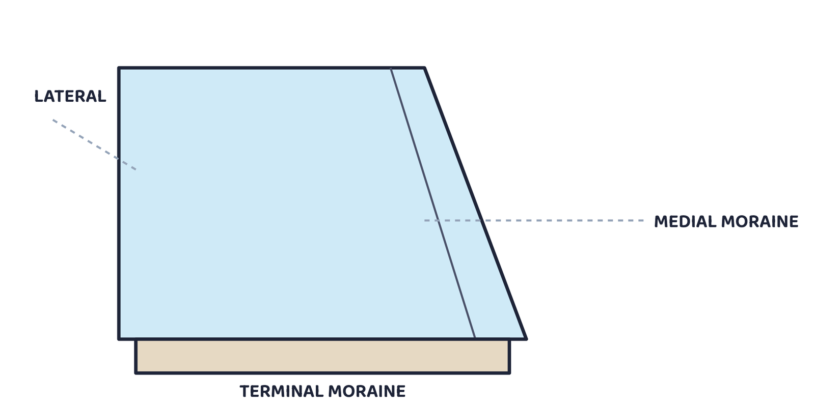
A moraine is a landform made of rock, soil and debris (called till) that a glacier carries and leaves behind when it melts. Moraines often create fertile soil, and can also form natural dams and lakes.
| Type of moraine | Where it forms |
|---|---|
| Lateral moraine | Along the sides of a glacier |
| Terminal moraine | At the end of a glacier, marking its furthest advance |
| Medial moraine | Down the middle, where two glaciers meet and their lateral moraines join |
In February 2021, a sudden flood struck Chamoli district in Uttarakhand, killing many people and damaging buildings, roads and hydel projects. Such disasters are often linked to melting glaciers and unstable mountain slopes.
7 Landforms Made by Wind
In dry and desert areas, wind picks up loose sand and dust and slowly reshapes the land.
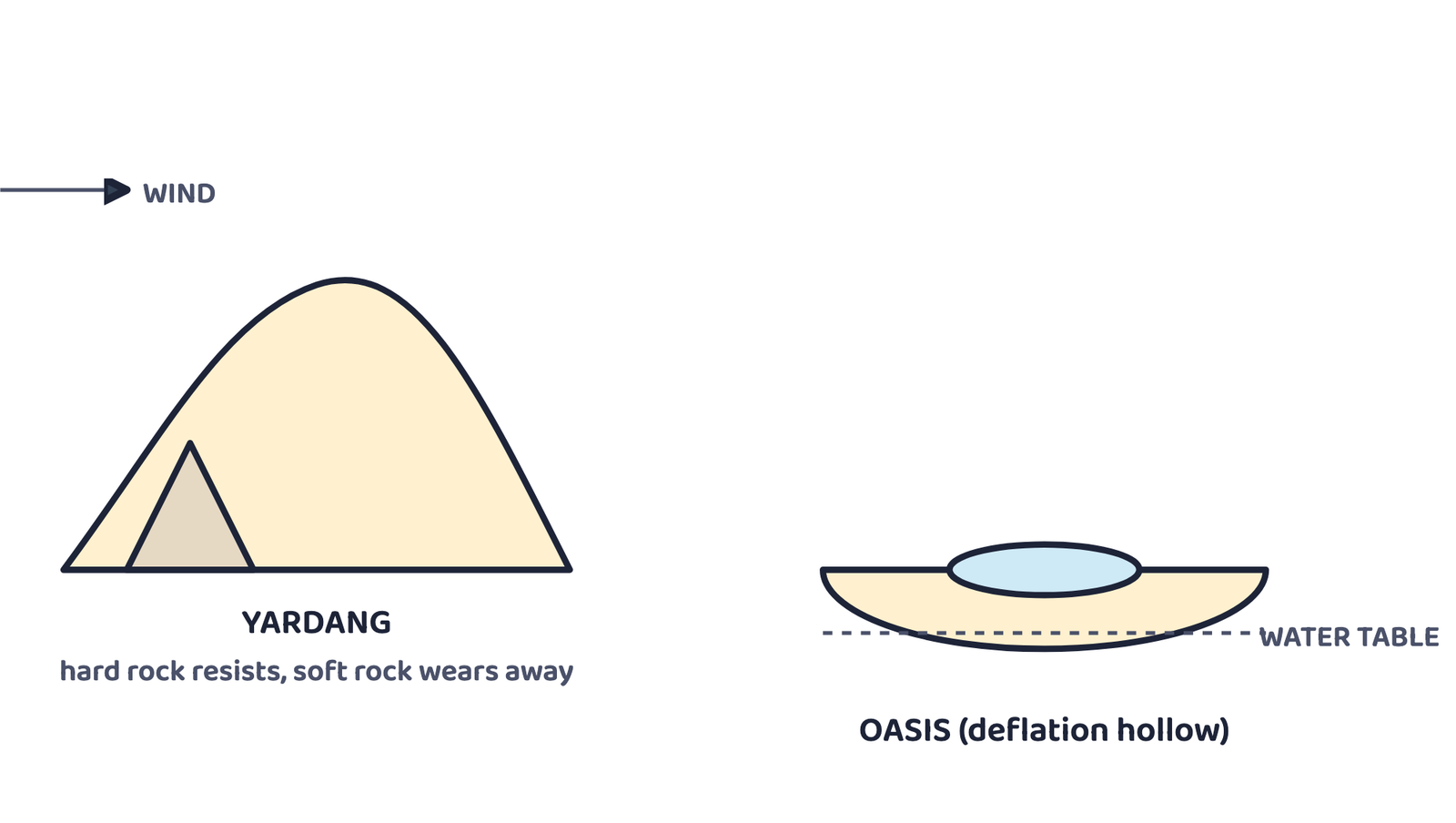
| Wind erosion landform | How it forms |
|---|---|
| Yardang | A streamlined rock ridge carved by wind-blown sand |
| Ventifact | A rock polished and shaped by sandblasting |
| Deflation hollow (blowout) | A shallow depression formed where loose material has been blown away |
| Desert pavement | A flat, stony surface left behind after finer particles are blown away |
A sand dune is a hill or ridge of sand built up by wind, found in deserts or along sandy coasts.
| Type of dune | Shape and cause |
|---|---|
| Barchan dune | Crescent-shaped, forms where sand is limited and the wind blows from one direction |
| Longitudinal dune | Long ridge, forms parallel to the prevailing wind |
| Star dune | Has several arms, forms where winds blow from different directions |
| Parabolic dune | U-shaped, often held in place by vegetation |
8 Landforms Made by Underground Water
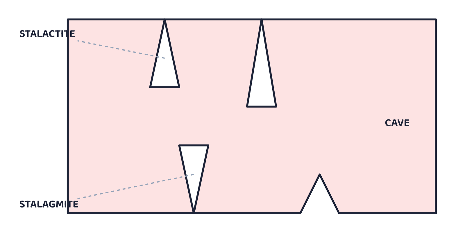
Karst topography is a landscape of unique landforms created when underground water chemically dissolves soluble rock, especially limestone.
| Karst landform | How it forms |
|---|---|
| Cave | A hollow space formed as acidic water dissolves rock |
| Stalactite | An icicle-shaped formation that hangs from a cave’s ceiling |
| Stalagmite | A formation that rises up from a cave’s floor |
| Sinkhole (doline) | A depression formed when the ground collapses into an underground cavity |
| Underground river | A river that flows through a cave system |
9 Landforms and Disasters
Some landforms and processes learnt above are also linked to natural disasters. Four common ones are landslides, avalanches, GLOFs and dust storms.
| Disaster | Main causes | Prone areas | Mitigation |
|---|---|---|---|
| Landslide | Heavy rainfall, earthquakes, steep slopes with loose rock, deforestation, mining, unplanned construction | Steep Himalayan and Western Ghat slopes | Afforestation, terracing, retaining walls, avoiding construction on unstable slopes |
| Avalanche | Heavy snowfall, weak snow layers, sudden temperature rise, strong winds, vibrations | High, snow-covered mountain slopes such as the Himalaya | Snow fences, avoiding unstable slopes, early-warning systems |
| GLOF (Glacial Lake Outburst Flood) | Rapid glacier melting, pressure on ice or moraine dams, heavy rain, earthquakes or landslides triggering collapse | Glacial lakes in the Himalayan region, e.g. Chamoli, Uttarakhand (2021) | Monitoring glacial lakes, controlled drainage, early-warning systems |
| Dust storm | Strong winds, drought, sparse vegetation, overgrazing, climate change | Desert and semi-arid regions such as the Thar | Shelterbelts of trees, afforestation, better farming practices |
If you live in an earthquake-prone region, remember: keep heavy objects low, know the safest spots in each room (under a sturdy table, away from windows), keep an emergency kit ready, and practise a family evacuation plan.
- The Earth has three main layers: crust, mantle and core; the crust and upper mantle together form the lithosphere.
- Tectonic plates float on the semi-molten asthenosphere and move because of convection currents inside the Earth.
- Convergent boundaries build fold mountains or cause subduction; divergent boundaries create mid-ocean ridges; transform boundaries mainly cause earthquakes.
- Weathering breaks rock down in place; erosion breaks it down AND carries it away.
- The five agents of gradation are running water, glaciers, wind, waves and groundwater.
- A river builds waterfalls and rapids in its upper course, meanders in its middle course, and deltas in its lower course.
- Waves cut cliffs into caves, arches and finally stacks; glaciers carve cirques, aretes and U-shaped valleys; wind carves yardangs and builds dunes; groundwater dissolves limestone into caves, stalactites and stalagmites.
- Landslides, avalanches, GLOFs and dust storms are disasters linked to specific landforms and processes.
- 1 markDefine a landform.
- 1 markWhat is the lithosphere made of?
- 1 markName the three main types of tectonic plates.
- 1 markDefine weathering.
- 1 markWhat is a moraine?
- 1 markName any two landforms created by underground water.
- 3 marksDifferentiate between weathering and erosion.
- 3 marksWhat are the sources of energy that cause the movements associated with the internal forces of the Earth?
- 3 marksWhy and where do earthquakes occur frequently? Is it possible to predict earthquakes?
- 2 marksHow are deforestation and erosion associated with each other?
- 3 marksExplain the three types of plate boundaries with one example each.
- 3 marksWhat causes convection currents inside the Earth, and how do they move tectonic plates?
- 3 marksRelate the physiographic divisions you have studied in earlier grades to the endogenic forces responsible for their origin.
- 2 marksDistinguish between a delta and a meander.
- 5 marks“Plate movements are responsible for the distribution of earthquakes and volcanoes.” Explain.
- 5 marksDraw and label a diagram of a meander and a delta.
- 5 marksDescribe the landforms created by any two agents of gradation, with examples.
- 5 marksExplain the causes of any two landform-related disasters and suggest mitigation measures for each.
- 1 markWhich scientist gave the theory of plate tectonics?
(a) Alfred Wegener(b) W.J. Morgan(c) Charles Darwin(d) James Hutton - 1 markThe semi-molten layer on which tectonic plates slide is the:
(a) Crust(b) Lithosphere(c) Asthenosphere(d) Inner core - 1 markFold mountains like the Himalaya form at a:
(a) Divergent boundary(b) Transform boundary(c) Convergent boundary(d) Mid-ocean ridge - 1 markThe Mid-Atlantic Ridge formed at a:
(a) Convergent boundary(b) Divergent boundary(c) Transform boundary(d) Subduction zone - 1 markMost earthquakes and volcanoes occur along the:
(a) Equator(b) Tropic of Cancer(c) Ring of Fire(d) Prime Meridian - 1 markA winding bend in the middle or lower course of a river is a:
(a) Delta(b) Meander(c) Waterfall(d) Moraine - 1 markCrescent-shaped dunes formed where sand is limited are called:
(a) Longitudinal dunes(b) Star dunes(c) Barchan dunes(d) Parabolic dunes - 1 markThe sudden release of water when a glacial lake’s ice or moraine dam breaks is a:
(a) Landslide(b) Avalanche(c) GLOF(d) Dust storm
Reason (R): At a convergent boundary, colliding plates push rock upward.
Reason (R): Weathering only breaks rock into smaller pieces; it does not transport it.
Reason (R): Rivers deposit rich alluvial sediment where they meet the sea.
- ActivityDevelop a plan to protect the land in your local area from erosion.
- ActivityDiscuss which disasters your own region might face, and prepare a mitigation plan for the class.
- ActivityPrepare a model of landforms created by underground water.
- ActivityPrepare a map showing landform-related disasters that happened this year.
- ActivityMake a poster of sacred or important landforms in your region, with the folk stories linked to them.