
- What actually makes something a “resource,” and the four ways resources are classified
- Why India needs resource planning, and the three steps that planning follows
- How land in India is used, and why land is degrading in different states for different reasons
- How to identify India’s six major soil types from their colour, location and best use
- What causes soil erosion, and the four methods used to stop it
net sown arealand degradationalluvial soilblack soil
laterite soilsoil erosioncontour ploughing
1What Is a Resource?
Look around your own house. A table is wood. A phone is metal, glass and plastic.
Even the water in your tap is a resource. But not everything around us is a resource
in the way geographers use the word.
A resource is everything available in our environment that can be used to
satisfy our needs, provided it is technologically accessible, economically feasible
and culturally acceptable.
Notice the three conditions in that definition. Oil under the ground, for
example, becomes a resource only once people have the technology to extract it and
a use for it. This is why the chapter says something that surprises most students
on first reading:
“Do you think that resources are free gifts of nature as is assumed by many?
They are not. Resources are a function of human activities. Human beings
themselves are essential components of resources.”
NCERT, Contemporary India II, Chapter 1
1.1 How Resources Are Classified
The same resource can be classified in four completely different ways, depending on
which question you are asking about it. Learn each base together with its two or
more categories as one unit.
By Origin
Biotic: from the living world (plants, animals, fish).
Abiotic: from non-living things (rocks, metals, water).
By Exhaustibility
Renewable: can be used again and again (solar energy, wind, water).
Non-renewable: takes millions of years to form. Once used up, it is gone
(coal, petroleum, minerals).
By Ownership
Individual: owned by one person (a farmer’s own plot).
Community: used by everyone in a locality (a village pond).
National: belongs to the nation (all minerals within India’s borders).
International: beyond any one country’s territory (the open ocean beyond
200 nautical miles).
By Status of Development
Potential: known to exist but not yet used (wind energy in Gujarat and
Rajasthan before wind farms were built).
Developed stock: surveyed, with quality and quantity determined for
present use.
Reserves: developed stock that is not being used right now but could be
used in the future.
O.E.O.D.: Origin, Exhaustibility, Ownership, Development-status
Say it as “Oh Every Old Dog” to remember all four bases in the order the book
gives them. If a question asks “classify resources on any two bases,” you now
have four to choose from.

and human institutions interact (the book’s Fig. 1.1: interdependent relationship
between nature, technology and institutions).
2Development of Resources, and Sustainable Development
It was believed that resources are free gifts of nature. Because of this belief, humans used resources indiscriminately, and
three connected problems appeared:
An equitable distribution of resources has become essential for a sustained
quality of life and global peace. If the present trend of resource depletion by a
few individuals and countries continues, the future of our planet is in danger.
Therefore, resource planning is essential for the sustainable existence of all
forms of life, and sustainable existence is a component of sustainable
development.
The response to this chain of problems is the idea of sustainable development.
Sustainable [economic] development means that development should take
place without damaging the environment, and development in the present should not
compromise with the needs of the future generations.
Learn these two definitions, sustainable development and Agenda 21, in the
book’s wording.
Agenda 21 is the declaration signed by world leaders in 1992 at the United
Nations Conference on Environment and Development (UNCED) in Rio de Janeiro,
Brazil. It aims at achieving global sustainable development by fighting
environmental damage, poverty and disease through global cooperation. One of its
main goals is that every local government should draw up its own local Agenda 21.
“There is enough for everybody’s need and not for any body’s greed.”
Mahatma Gandhi, on resource conservation
Gandhiji blamed greedy, selfish individuals and the exploitative nature of modern
technology for resource depletion at the global level. He was against mass
production, and wanted production done by the masses instead.
3Resource Planning
Planning is the widely accepted strategy for the judicious (wise) use of resources.
It matters even more in a country like India, which has enormous diversity in the
availability of resources. Some regions are rich in one type of resource but
deficient in another; some are self-sufficient overall; some have an acute
shortage of vital resources.
| Region | Rich in | Falls short in |
|---|---|---|
| Jharkhand, Chhattisgarh, Madhya Pradesh | Minerals and coal deposits | — |
| Arunachal Pradesh | Water resources | Infrastructural development |
| Rajasthan | Solar and wind energy | Water resources |
| Ladakh (cold desert) | Rich cultural heritage | Water, infrastructure, some vital minerals |
This is exactly why India needs balanced resource planning at the national, state,
regional and local levels.
3.1 Resource Planning in India: the Three Steps
Identification and inventory
Surveying, mapping and estimating resources, both qualitatively and
quantitatively, across every region of the country.
Planning structure
Evolving a structure with the right technology, skill and institutional
set-up to actually carry out resource development plans.
Matching plans
Matching the resource development plans with the country’s overall national
development plans.
India has made concerted efforts towards these goals since the First Five Year
Plan, launched right after Independence.
Students often write that a region develops automatically once it has plenty of
resources. The book explicitly disagrees: mere availability of resources does not
cause development without matching technology and institutional change. There are
resource-rich regions that stay economically backward, and resource-poor regions
that are economically developed. Remember at least one example of each if the
question asks for it.
The history of colonisation shows this clearly. Resource-rich colonies were the
main attraction for foreign invaders, and it was the coloniser’s higher level of
technological development, not the resources alone, that let them exploit those
colonies and establish supremacy over them. India experienced this in different
phases of colonisation, which is why resource development in India depends not just
on the resources available but also on technology, the quality of human resources,
and historical experience.
4Conservation of Resources
Resources are vital for any developmental activity, but irrational consumption and
over-utilisation can create serious social, economic and environmental problems.
Conserving resources at every level, from a single household to the whole planet,
has been a concern of leaders and thinkers for a long time (see the timeline in
Section 2 above: Club of Rome, Schumacher, the Brundtland Commission and the Rio
Earth Summit are all part of this same conservation story).
5Land Resources
We live on land, we carry out our economic activities on land, and we use it in
many different ways: it supports natural vegetation, wildlife, human life,
economic activity, and transport and communication systems. But land is an asset of
a finite magnitude, and India cannot make more of it, so using the available
land carefully and with planning matters.
India’s land comes under a variety of relief features: mountains, plateaus,
plains and islands. About 43% of the land area is plain, mountains account for 30%
of the total surface area, and about 27% of the area is plateau. Each serves a
different purpose:
Plains provide facilities for agriculture and industry. Mountains ensure the
perennial flow of some rivers and provide facilities for tourism, along with
ecological benefits. The plateau region possesses rich reserves of minerals,
fossil fuels and forests.
6Land Utilisation
Land resources in India are used for five broad purposes, each with its own
sub-categories.
| Category | What it includes |
|---|---|
| 1. Forests | Land under forest cover |
| 2. Land not available for cultivation | (a) Barren and waste land |
| (b) Land put to non-agricultural uses: buildings, roads, factories | |
| 3. Other uncultivated land (excluding fallow) | (a) Permanent pastures and grazing land |
| (b) Land under miscellaneous tree crops/groves (not part of net sown area) | |
| (c) Culturable waste land: left uncultivated for more than 5 agricultural years | |
| 4. Fallow lands | (a) Current fallow: uncultivated for one agricultural year or less |
| (b) Other than current fallow: uncultivated for 1 to 5 agricultural years | |
| 5. Net sown area | The physical extent of land on which crops are actually sown and harvested |
Net sown area (NSA) is the physical extent of land on which crops are
sown and harvested.
Gross cropped area is the net sown area plus the area sown more than
once in the same agricultural year.
Net sown area and gross cropped area are not the same number. If a field grows
two crops in one year, it counts once towards net sown area but twice towards
gross cropped area.
7Land Use Pattern in India
How land gets used depends on physical factors, such as topography, climate and
soil type, and on human factors, such as population density, technological
capability, culture and tradition.
Land-use data is missing for the other 7% of the area because most north-eastern
states except Assam have not completed their land-use reporting, and some areas of
Jammu and Kashmir occupied by Pakistan and China have also not been surveyed.
Comparing the two pie charts of Fig. 1.4 (1960-61 and 2019-20), the net sown area
and the land under forests have changed only marginally. The land under permanent
pasture has also decreased. Most of the “other than current fallow” lands are
either of poor quality or the cost of cultivating them is very high, so they are
cultivated only once or twice in about two to three years. The livelihood of
millions of people who live on the fringes of forests depends on the forests. A
part of the land is termed waste land: waste land includes rocky, arid and desert
areas, while land put to other non-agricultural uses includes settlements,
roads, railways, industry, etc.
The share of net sown area varies hugely between states:
| Net sown area | States |
|---|---|
| Over 80% of total area | Punjab, Haryana |
| Less than 10% of total area | Arunachal Pradesh, Mizoram, Manipur, Andaman & Nicobar Islands |
Remember the National Forest Policy (1952) and its target of 33% of
geographical area under forest, which it considered essential for the maintenance
of the ecological balance. Forest area in the country is far lower than this
desired 33%.
8Land Degradation and Conservation Measures
We have shared our land with past generations and will share it with future ones
too. About 95% of our basic needs for food, shelter and clothing come from land.
Human activities have not only degraded land directly, but have also sped up the
natural forces that damage it.
Some human activities such as deforestation, overgrazing, mining and
quarrying have contributed significantly to land degradation. The cause
named by the chapter is different in different states, so learn each cause
with its states.
Do not write “deforestation” as the answer for every land-degradation question.
The chapter ties different causes to different states.
| Cause named in the chapter | States |
|---|---|
| Deforestation due to mining | Jharkhand, Chhattisgarh, Madhya Pradesh, Odisha |
| Overgrazing | Gujarat, Rajasthan, Madhya Pradesh, Maharashtra |
| Over-irrigation (waterlogging → salinity and alkalinity) | Punjab, Haryana, western Uttar Pradesh |
Mineral processing (grinding limestone for cement, or calcite and soapstone for
ceramics) throws huge amounts of dust into the atmosphere, which settles on land
and retards the infiltration of water into the soil. In recent years, industrial
effluents as waste have become a major source of land and water pollution in many
parts of the country.
✓ Ways to fix land degradation
- Afforestation and proper management of grazing (these can help to some extent)
- In arid areas: planting shelter belts of plants, control on overgrazing, and stabilising sand dunes by growing thorny bushes
- Proper management of waste lands and control of mining activity
- Proper discharge and disposal of industrial effluents and wastes after treatment
✗ What keeps making it worse
- Continuous cultivation without conservation measures
- Unchecked overgrazing on the same pasture land
- Discharging industrial waste without treatment
- Over-irrigation, which leads to waterlogging
9Soil as a Resource
Soil is the most important natural resource. It is the medium of plant growth
and supports different types of living organisms on the earth. Soil is a living
system: it takes millions of years to form soil up to a few centimetres in depth.
Relief, parent rock or bed rock, climate, vegetation and other forms of life, and
time are important factors in the formation of soil, and natural
forces such as temperature change, running water, wind, glaciers and decomposer
organisms keep contributing to it. Soil is made of both organic material
(humus) and inorganic material.

from the surface down to solid rock.
10Classification of Soils
India’s varied relief, climate and vegetation have produced several distinct
types of soil, classified by their formation, colour, thickness, texture, age and
chemical and physical properties.
10.1 Alluvial Soils
This is the most widespread and important soil in India. The entire northern
plains are made of it. It is deposited by three great Himalayan river systems:
the Indus, the Ganga and the Brahmaputra. It also extends through a narrow
corridor into Rajasthan and Gujarat, and appears in the eastern coastal deltas of
the Mahanadi, Godavari, Krishna and Kaveri rivers.
Alluvial soil contains sand, silt and clay in various proportions. Moving
inland towards the river valleys, the soil particles become somewhat bigger; in the
upper reaches of a valley, near the break of slope, the soils are coarse. Such
coarse soils are common in piedmont plains such as the Duars, Chos and
Terai.
Bangar (old alluvial)
- Older alluvium
- Higher concentration of kankar nodules than the Khadar
Khadar (new alluvial)
- Newer alluvium
- More fine particles, more fertile than the Bangar
Alluvial soil is rich in potash, phosphoric acid and lime, making it ideal for
sugarcane, paddy, wheat and other cereal and pulse crops. Because it is so
fertile, alluvial-soil regions are intensively cultivated and densely
populated. Soils in the drier areas are more alkaline, and can be productive
after proper treatment and irrigation.

Punjab plains, deposited by the Indus river system.
Photo: Sarbjit Bahga / Wikimedia Commons / CC BY-SA 4.0
10.2 Black Soil (Regur)
Black in colour, and also known as regur soil or black cotton soil because
it is ideal for growing cotton. Climatic condition along with the parent rock
material are believed to be the important factors for its formation. It is typical
of the Deccan Trap (basalt) region and is made up of lava flows. It covers the plateaus of Maharashtra, Saurashtra, Malwa, Madhya
Pradesh and Chhattisgarh, extending south-east along the Godavari and Krishna
valleys. It is made of extremely fine, clayey material, holds moisture very well,
and is rich in calcium carbonate, magnesium, potash and lime, though poor in
phosphoric content. In hot weather it develops deep cracks, which help in the
proper aeration of the soil. When wet it becomes sticky and difficult to work on,
so it has to be tilled immediately after the first shower or during the
pre-monsoon period.
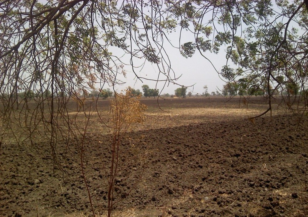
Photo: Ganesh Dhamodkar / Wikimedia Commons / CC BY 3.0
10.3 Red and Yellow Soils
Red soil develops on crystalline igneous rocks in low-rainfall areas of the
eastern and southern Deccan plateau. Yellow and red soils are also found in
Odisha, Chhattisgarh, the southern part of the middle Ganga plain, and along the
piedmont zone of the Western Ghats. The red colour comes from iron diffusing
through crystalline and metamorphic rocks; the same soil looks yellow when it
occurs in a hydrated form.
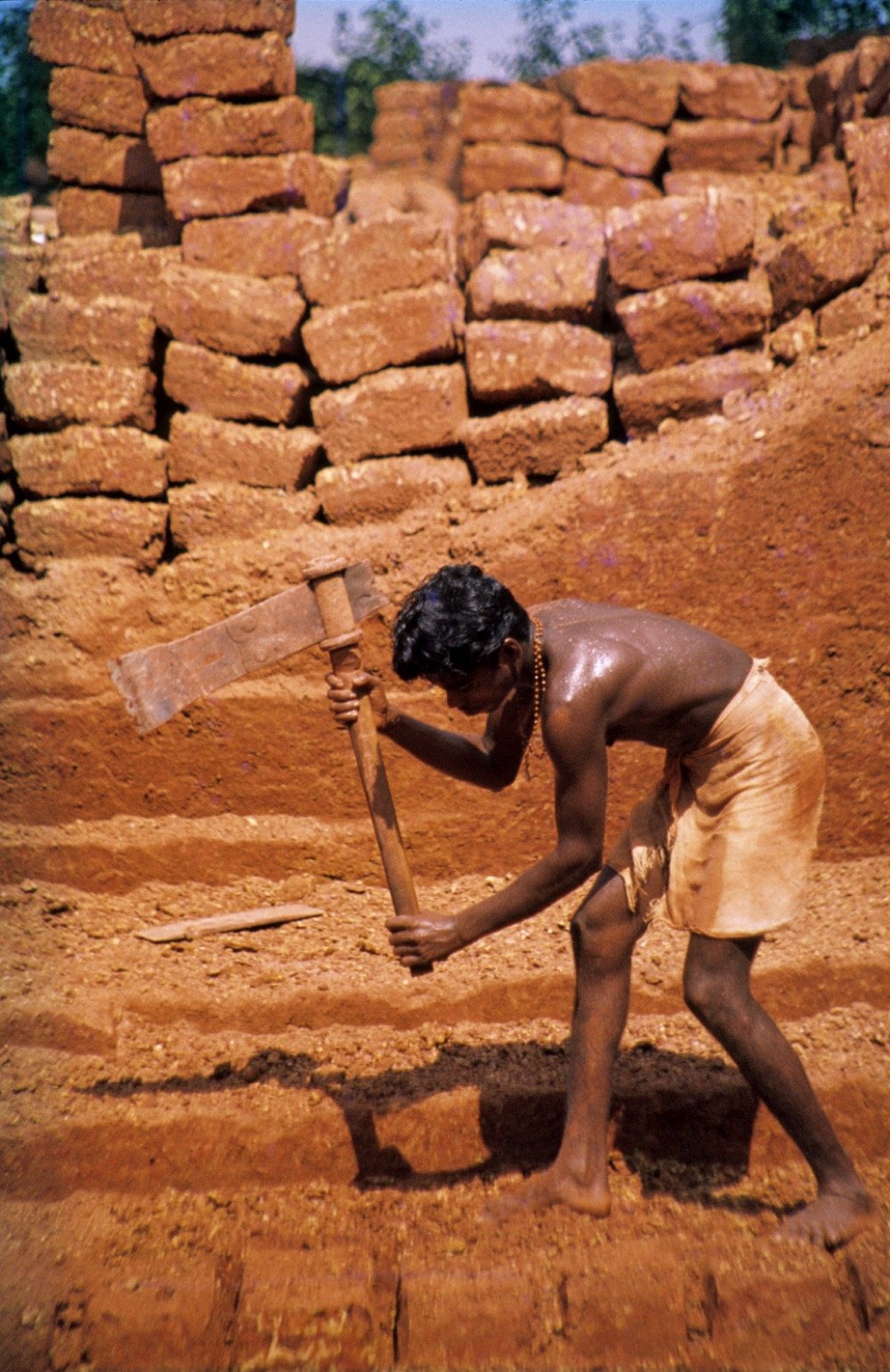
10.4 Laterite Soil
The word “laterite” comes from the Latin word later, meaning brick.
Laterite forms under tropical and subtropical climates with alternating wet and
dry seasons, as a result of intense leaching caused by heavy rain. It is mostly
deep to very deep, acidic (pH below 6.0), and generally short of plant nutrients.
It is found mainly in southern states, the Western Ghats region of Maharashtra,
Odisha, parts of West Bengal and the north-eastern states. Where it supports
deciduous or evergreen forest it is humus-rich, but under sparse, semi-arid
vegetation it is humus-poor. After proper soil conservation techniques, laterite
soil in the hilly parts of Karnataka, Kerala and Tamil Nadu is used to grow tea
and coffee, and the red laterite soils of Tamil Nadu, Andhra Pradesh and Kerala
suit cashew nut cultivation.
soil’s characteristic deep, brick-red profile.
Photo: Werner Schellmann / Wikimedia Commons / CC BY-SA 2.5
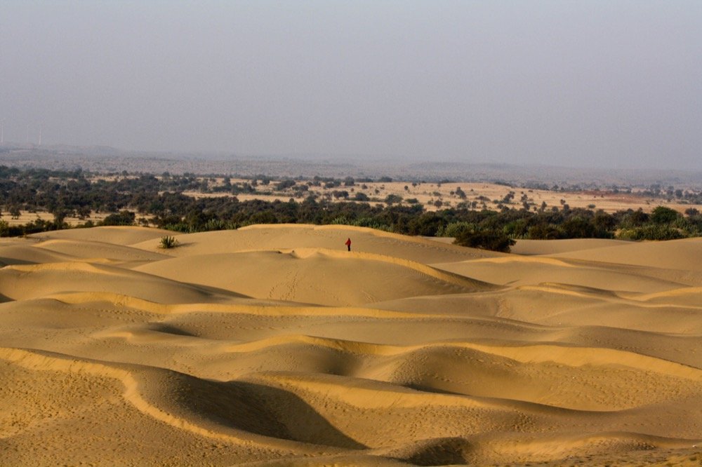
10.5 Arid Soils
Arid soils range from red to brown, are generally sandy and saline. In some
areas the salt content is so high that common salt is obtained simply by
evaporating water. Because the climate is dry and hot, evaporation is fast, so
these soils lack humus and moisture. Rising calcium content lower down forms a
Kankar layer that restricts water infiltration. After proper irrigation these
soils become cultivable, as has happened in western Rajasthan.
saline character of arid soil.
Photo: Sushmita Balasubramani / Wikimedia Commons / CC BY 2.0
10.6 Forest Soils
Found in hilly and mountainous areas with sufficient rainfall, forest soil’s
texture varies with the mountain environment: loamy and silty on valley sides,
coarse-grained on the upper slopes. In the snow-covered Himalayan areas these
soils are heavily denuded, acidic and low in humus, but in the lower parts of
valleys, especially river terraces and alluvial fans, they are fertile.
10.7 All Six Soil Types at a Glance
| Soil type | Where found | Key property | Best for |
|---|---|---|---|
| Alluvial | Northern plains; deltas of Mahanadi, Godavari, Krishna, Kaveri | Very fertile; Bangar (old) vs Khadar (new) | Sugarcane, paddy, wheat |
| Black (Regur) | Maharashtra, Saurashtra, Malwa, MP, Chhattisgarh | Clayey, moisture-retentive, self-aerating cracks | Cotton |
| Red and Yellow | Eastern/southern Deccan plateau, Odisha, Chhattisgarh | Red from iron; yellow when hydrated | No crop named in the chapter |
| Laterite | Southern states, Western Ghats, Odisha, West Bengal, NE India | Deep, acidic (pH<6.0), leached | Tea, coffee, cashew |
| Arid | Dry, hot areas (the chapter’s example: western Rajasthan) | Sandy, saline, Kankar layer | Cultivable after irrigation |
| Forest | Hilly and mountainous areas, Himalayas | Texture varies with elevation | Fertile in the lower parts of valleys, on river terraces and alluvial fans |
11Soil Erosion and Soil Conservation
Soil erosion is the denudation of the soil cover and its subsequent
washing away, disturbing the natural balance between soil formation and soil
loss.
This natural balance gets disturbed by human activities such as deforestation,
overgrazing, construction and mining, and by natural forces such as wind, glaciers
and water.
Gully erosion
Running water cuts deep channels called gullies through clayey soil, making
the land unfit for cultivation (“bad land”). In the Chambal basin such land is
called ravines.
Sheet erosion
Water flows as a sheet over a large sloping area, washing away the top soil
across the whole surface rather than cutting channels.
Wind erosion
Wind blows loose soil off flat or sloping land.
Defective farming
Soil erosion is also caused by defective methods of farming. Ploughing in a
wrong way, up and down the slope, forms channels for the quick flow of water,
leading to soil erosion.
The chapter describes four methods of soil conservation:
Contour ploughing
Ploughing along the contour lines of a slope, instead of up and down it,
slows the flow of water downhill.
Terrace cultivation
Cutting steps (terraces) into a slope restricts erosion. Western and
central Himalayas have well-developed terrace farming.
Strip cropping
Large fields are divided into strips, with strips of grass grown between
the crops to break the force of the wind.
Shelter belts
Rows of trees planted to block wind. Shelter belts have significantly
helped stabilise sand dunes and the desert in western India.
- A resource needs three things at once: technological access, economic feasibility, cultural acceptance
- Resources are classified by origin, exhaustibility, ownership and status of development
- Unplanned resource use led to depletion, inequality and global ecological crises, which is why sustainable development and Agenda 21 (1992) matter
- India’s resource planning has three steps: identify and survey, build a planning structure, match it to national plans
- Resources alone do not cause development; technology and institutions must go with them
- Land is used for five purposes: forests, land not available for cultivation, other uncultivated land, fallow land, and net sown area
- Land degrades differently by state: mining-linked deforestation (Jharkhand/Chhattisgarh/MP/Odisha), overgrazing (Gujarat/Rajasthan/MP/Maharashtra), over-irrigation (Punjab/Haryana/western UP)
- India has six major soil types: alluvial, black, red and yellow, laterite, arid and forest soil, each tied to specific regions
- Soil erosion happens as gully, sheet or wind erosion (and through defective farming), and is fought with contour ploughing, terracing, strip cropping and shelter belts