
- Every mode of transport in India, roads, railways, pipelines, waterways and airways, with the exact figures and named routes the book gives for each
- India’s major sea ports, one line of identity for each, and the share of India’s foreign trade they handle
- How communication (postal, mass media) has grown, and the schemes behind it
- What trade, international trade and the balance of trade mean, and why transport and communication are called the “lifelines” of a nation’s economy
1Why Transport, Communication and Trade Matter
Goods and services are not always available where they are needed. They must be carried from where they are made or grown (supply locations) to where they are wanted (demand locations), and this movement needs transport. The people who carry products to consumers this way are called traders. A country’s pace of development depends not only on how much it produces, but on how well those goods and services move over space.
A dense and efficient network of transport and communication is a prerequisite for local, national and global trade today. That is why the chapter describes modern means of transport and communication as “lifelines of our nation and its modern economy”, and says that transport, communication and trade are complementary to each other.
2Roadways
In India, roads were built before railways, and still hold an edge over rail transport: lower construction cost than railway lines; can cross more dissected, undulating land and steeper gradients (even the Himalayas); economical for few people or small goods over short distances; give door-to-door service, so loading/unloading costs stay low; and act as a feeder to other modes, linking railway stations, airports and seaports.
2.1 Six classes of roads, by capacity
Golden Quadrilateral
Six-lane super highways linking Delhi-Kolkata-Chennai-Mumbai and Delhi, implemented by the National Highway Authority of India (NHAI). The North-South Corridor (Srinagar-Kanniyakumari) and the East-West Corridor (Silchar-Porbander) are part of this project. Aim: reduce the time and distance between the mega cities.
National Highways
Link the extreme parts of the country; the primary road system. A number of major National Highways run in North-South and East-West directions.
State Highways
Connect a state capital with the different district headquarters of that state.
District Roads
Connect the district headquarters with other places in the same district.
Other Roads
Rural roads linking villages and rural areas with towns. Get special support under the Pradhan Mantri Grameen Sadak Yojana, under which special provisions are made so that every village is linked to a major town by an all-season motorable road.
Border Roads
Built and maintained by the Border Roads Organisation, set up in 1960 for strategically important roads in the northern and north-eastern border areas.
The world’s longest highway tunnel above 10,000 feet, the Atal Tunnel (9.02 km), was built by the Border Roads Organisation. It connects Manali to the Lahaul-Spiti valley all year round, in the Pir Panjal range of the Himalayas at about 3,000 metres above sea level. Before the tunnel, the valley was cut off for around six months every year by heavy snowfall.
Roads are also classified by the material used to build them: metalled roads (cement, concrete or bitumen) can be used in all weather; unmetalled roads go out of use in the rainy season.
3Railways
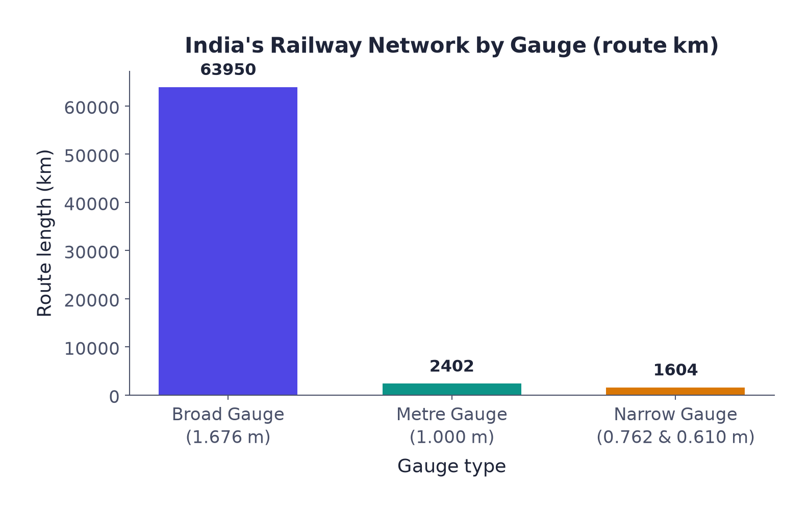
Railways are India’s principal mode of transport for both freight and passengers, and for more than 150 years they have been a great integrating force, allowing trade, business, sightseeing and pilgrimage over long distances. The Indian Railways is the largest public-sector undertaking in the country. The first train ran in 1853, from Mumbai to Thane, a distance of 34 km, and the network is now reorganised into 17 zones.
| Gauge | Track width | Route length (km) |
|---|---|---|
| Broad Gauge | 1.676 m | 63,950 |
| Metre Gauge | 1.000 m | 2,402 |
| Narrow Gauge | 0.762 m and 0.610 m | 1,604 |
| Total | 67,956 |
Source (book): Railway Yearbook 2019-20, Ministry of Railways, Government of India.
The way railways are spread across the country depends on physical, economic and administrative factors. The northern plains were most favourable: flat land, high population, rich agriculture, although the many rivers there needed bridges. Hilly parts of the peninsula needed tracks through low hills, gaps or tunnels, and the Himalayan region is unfavourable for railways, high relief, thin population, few economic opportunities. Lines were also hard to lay through the sandy plains of western Rajasthan, the swamps of Gujarat, and the forests of Madhya Pradesh, Chhattisgarh, Odisha and Jharkhand; the Sahyadri range can only be crossed through gaps or passes (Ghats). The recent Konkan Railway along the west coast has eased movement in this key economic region, though it faces track-sinking and landslides.
Rail transport problems named in the book are ticketless travel, theft and damage of railway property, and unnecessary chain-pulling, not “overcrowding” or “delays”, which the book does not mention as a listed problem.
4Pipelines
Pipelines are a newer addition to India’s transport network. In the past they were used to carry water to cities and industries; now they carry crude oil, petroleum products and natural gas from oil and gas fields to refineries, fertilizer factories and thermal power plants; even solids can travel through a pipeline once turned into slurry. Laying a pipeline costs a lot up front, but running costs afterwards are minimal, and pipelines rule out trans-shipment losses or delays. Far-inland refineries such as Barauni, Mathura and Panipat, and gas-based fertilizer plants, were only possible because pipelines could reach them.
| Pipeline network | Route |
|---|---|
| 1 | Upper Assam oil fields → Kanpur (UP), via Guwahati, Barauni and Prayagraj; branches from Barauni to Haldia (via Rajbandh), Rajbandh to Maurigram, and Guwahati to Siliguri |
| 2 | Salaya (Gujarat) → Jalandhar (Punjab), via Viramgam, Mathura, Delhi and Sonipat; branches to Koyali (near Vadodara) and Chakshu |
| 3 | The Hazira-Vijaipur-Jagdishpur (HVJ) cross-country gas pipeline, first laid at 1,700 km, linking Mumbai High and Bassein gas fields to fertilizer, power and industrial complexes in western and northern India |
5Waterways
Since ancient times India has been one of the seafaring countries; its seamen carried Indian commerce and culture far and near. Waterways are the cheapest mode of transport, best suited to heavy and bulky goods, fuel-efficient and environment-friendly. India has 14,500 km of inland navigation waterways.
To build a wide waterways network and promote inland water transport as an economical, environment-friendly supplement to rail and road, 111 inland waterways (including 5 National Waterways declared earlier) were declared National Waterways by the National Waterways Act, 2016.
| National Waterway | Route | Length |
|---|---|---|
| NW No. 1 | The Ganga, between Prayagraj and Haldia | 1,620 km |
| NW No. 2 | The Brahmaputra, between Sadiya and Dhubri | 891 km |
| NW No. 3 | The West-Coast Canal in Kerala (Kottapurma-Kollam, Udyogamandal and Champakkara canals) | 205 km |
| NW No. 4 | Stretches of the Godavari and Krishna, with the Kakinada-Puducherry canal stretch | 1,078 km |
| NW No. 5 | Stretches of the Brahmani, with the Matai river, Mahanadi delta channels and the East Coast Canal | 588 km |
Other inland waterways carrying substantial traffic, without a measured length in the book: the Mandavi, Zuari and Cumberjua rivers, the Sunderbans, the Barak, and the backwaters of Kerala.
6Major Sea Ports
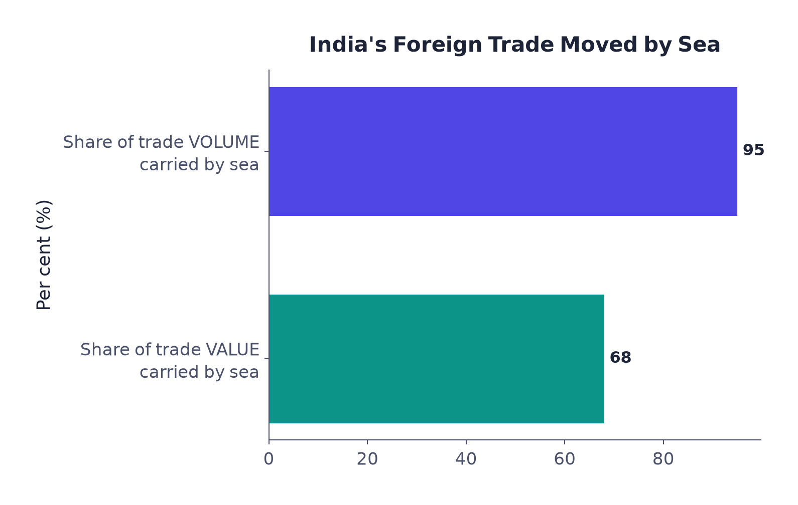
India’s trade with foreign countries moves mainly through ports on its coastline of 11,098.81 km, which is dotted with 12 major ports and 200 notified non-major (minor/intermediate) ports. The major ports alone handle 95% of India’s foreign trade, and overall 95% of the country’s trade volume (68% by value) is moved by sea.
| Port | What makes it important |
|---|---|
| Deendayal Port (Kandla) | The first port developed soon after Independence, to ease the volume of trade on Mumbai port in the wake of the loss of Karachi port to Pakistan after the Partition. A tidal port serving J&K, Himachal Pradesh, Punjab, Haryana, Rajasthan and Gujarat. |
| Mumbai | India’s biggest port, with a spacious, natural, well-sheltered harbour. |
| Jawaharlal Nehru Port | Built to decongest Mumbai port and act as a hub port for the region. |
| Mormugao (Goa) | Premier iron-ore exporting port, handling about 50% of India’s iron-ore exports. |
| New Mangalore (Karnataka) | Exports iron-ore concentrate from the Kudremukh mines. |
| Cochin | Extreme south-western port, a natural harbour at the entrance of a lagoon. |
| V.O. Chidambaranar (Tuticorin), Tamil Nadu | Extreme south-eastern port, natural harbour, rich hinterland; trades with Sri Lanka, Maldives and India’s coastal regions. |
| Chennai | One of the oldest artificial ports; ranks next to Mumbai in trade and cargo volume. |
| Vishakhapatnam | The deepest landlocked and well-protected port (its harbour is enclosed by land, though the port is on the coast), originally conceived as an outlet for iron-ore exports. |
| Paradwip (Odisha) | Specialises in iron-ore export. |
| Shyama Prasad Mookerjee Port, Kolkata | An inland riverine port serving the Ganga-Brahmaputra basin; a tidal port needing constant dredging of the Hooghly. |
| Haldia | Developed as a subsidiary port to relieve pressure on the Kolkata port. |
7Airways
Air travel today is the fastest, most comfortable and most prestigious mode of transport. It can cover very difficult terrains, high mountains, dreary deserts, dense forests and long oceanic stretches, with great ease. This makes it especially valuable in the north-eastern states, where big rivers, dissected relief, dense forests and frequent floods make other transport difficult; air travel has made access easier.
Pawanhans Helicopters Ltd.
Provides helicopter services to the Oil and Natural Gas Corporation (ONGC) for its off-shore operations, and to inaccessible areas and difficult terrain such as the north-east and the interior of Jammu & Kashmir, Himachal Pradesh and Uttarakhand.
UDAN (Ude Desh ka Aam Nagrik)
A first-of-its-kind scheme globally, designed to jump-start the regional aviation market. Part of the Regional Connectivity Scheme (RCS) UDAN, conceived by the Ministry of Civil Aviation, to make flying affordable for the common citizen by encouraging airlines onto regional and remote routes.
8Communication
Long-distance communication today is far easier without any physical movement of the sender or receiver. Personal and mass communication (television, radio, the press, films) are the country’s major means of communication. India’s postal network is the largest in the world, and handles both parcels and personal written communication.
First-class mail
- Cards and envelopes
- Airlifted between stations
- Covers land and air routes
Second-class mail
- Book packets, registered newspapers, periodicals
- Carried by surface mail
- Covers land and water transport
To speed up delivery in large towns and cities, six mail channels were recently introduced: Rajdhani Channel, Metro Channel, Green Channel, Business Channel, Bulk Mail Channel and Periodical Channel.
Digital India is an umbrella programme to prepare India for a knowledge-based transformation. Its focus, in the programme’s own words, is: IT (Indian Talent) + IT (Information Technology) = IT (India Tomorrow), making technology central to change.
India has one of the largest telecom networks in Asia; more than two-thirds of villages (outside urban places) already have STD telephone facility, at a uniform rate across the whole country, made possible by combining space technology with communication technology. To strengthen the flow of information from the grassroots to the higher level, the government has made special provision to extend twenty-four-hour STD facility to every village in the country.
Mass communication provides entertainment and creates awareness among people about various national programmes and policies. It includes radio, television, newspapers, magazines, books and films.
| Mass medium | What the book says about it |
|---|---|
| All India Radio (Akashwani) | Broadcasts a variety of programmes in national, regional and local languages, for different groups across the country. |
| Doordarshan | India’s national television channel, one of the largest terrestrial networks in the world; broadcasts entertainment, education and sport for every age group. |
| Newspapers | Published in about 100 languages and dialects; the largest number are in Hindi, followed by English, then Urdu. |
| Film | India is the largest producer of feature films in the world (short films, video feature films and video short films). The Central Board of Film Certification certifies both Indian and foreign films. |
9International Trade
Trade is the exchange of goods among people, states and countries. The market is the place where such an exchange takes place.
Trade carried on within cities, towns and villages is local trade. Trade between two or more states is state-level trade. Trade between two countries, by sea, air or land routes, is international trade.
The advancement of a country’s international trade is an index of its economic prosperity, its “economic barometer.” As the resources are “space bound”, no country can survive without international trade.
Export and import are the two components of trade. The balance of trade is the difference between a country’s exports and its imports.
Favourable balance of trade
- Value of exports > value of imports
Unfavourable balance of trade
- Value of imports > value of exports
India trades with all the major trading blocks and geographical regions of the world.
| Direction | Commodities the book names |
|---|---|
| Exports from India | Gems and jewellery; chemicals and related products; agriculture and allied products. |
| Imports to India | Petroleum crude and products; gems and jewellery; chemicals and related products; base metals; electronic items; machinery; agriculture and allied products. |
India has emerged as a software giant at the international level, earning large foreign exchange through the export of information technology.
10Tourism as a Trade
Tourism in India has grown remarkably over the past two decades, helped by government initiatives, infrastructure development and global branding. Named schemes: Swadesh Darshan 2.0, the Vibrant Village Programme, PRASHAD (Pilgrimage Rejuvenation And Spiritual Heritage Augmentation Drive) and Paryatan Mitra. Tourism promotes national integration, supports local handicrafts and cultural pursuits, and helps in the development of international understanding about our culture and heritage.
“Why are transport and communication called the lifelines of a nation and its economy?” is a 120-word question in the book’s own exercises. A suggested answer plan (ours, not from the book): goods/services must move from supply to demand locations → trade needs transport → transport works with an equally developed communication system → the book calls transport, communication and trade complementary to each other, and a dense and efficient network of transport and communication a prerequisite for local, national and global trade.
- Can I name all six classes of roads, and one identifying fact for each?
- Can I state the total railway route length and the length of each of the three gauges?
- Can I name all five National Waterways, with their rivers and lengths?
- Can I name at least six of India’s major ports, and one identifying fact for each?
- Can I define trade, international trade and balance of trade, and tell favourable from unfavourable?
- Roads: 62.16 lakh km (2020-21), world’s 2nd largest; six classes: Golden Quadrilateral/NHAI (incl. N-S & E-W corridors), National, State, District, Other (PMGSY), Border (BRO, 1960)
- Railways: first train 1853, Mumbai-Thane, 34 km; 17 zones; 67,956 km total (Broad 63,950 + Metre 2,402 + Narrow 1,604)
- Pipelines: high set-up cost, cheap to run, no trans-shipment loss; HVJ 1,700 km; gas pipeline network grew from 1,700 km to 18,500 km
- Waterways: 14,500 km inland navigation; Act of 2016 made 111 waterways NWs; five named: Ganga, Brahmaputra, West-Coast Canal, Godavari-Krishna, Brahmani
- Coastline 11,098.81 km; 12 major + 200 non-major ports; 95% of trade volume (68% by value) moves by sea
- Air travel has made access to the north-east easier; Pawanhans serves ONGC; UDAN/RCS makes regional flying affordable
- Postal network is world’s largest; 6 mail channels; Digital India = IT (Indian Talent) + IT (Information Technology) = IT (India Tomorrow)
- Balance of trade = exports − imports; favourable when exports are higher, unfavourable when imports are higher
- Tourism schemes: Swadesh Darshan 2.0, Vibrant Village Programme, PRASHAD, Paryatan Mitra