
Every question from the Exercises at the end of NCERT’s Fundamentals of Physical Geography, Chapter 9, “Atmospheric Circulation and Weather Systems” (Chapter 15 on this site), in the exact order and wording printed in the book (English edition), with a full answer for each, followed by the in-text activity and the Project Work. Try answering it yourself first, then check against this one.
1 Multiple choice questions
Q. If the surface air pressure is 1,000 mb, the air pressure at 1 km above the surface will be:
(a) 700 mb (b) 1,100 mb (c) 900 mb (d) 1,300 mb
Answer: (c) 900 mb. In the lower atmosphere, pressure decreases at about 1 mb for every 10 m increase in elevation, so at 1 km (1,000 m) the decrease is roughly 100 mb, taking the surface pressure of 1,000 mb down to about 900 mb; this also matches the chapter’s own Table 9.1 figures (sea level 1,013.25 mb, 1 km 898.76 mb).
Q. The Inter Tropical Convergence Zone normally occurs:
(a) near the Equator (b) near the Tropic of Cancer (c) near the Tropic of Capricorn (d) near the Arctic Circle
Answer: (a) near the Equator. Winds from the tropics converge at this low-pressure zone near the equator, where the converged air rises with the convective cell (the Hadley cell).
Q. The direction of wind around a low pressure in northern hemisphere is:
(a) clockwise (b) perpendicular to isobars (c) anti-clock wise (d) parallel to isobars
Answer: (c) anti-clock wise. The chapter’s own Table 9.2 gives the wind pattern around a cyclone (low pressure) in the northern hemisphere as anticlockwise, and clockwise in the southern hemisphere.
Q. Which one of the following is the source region for the formation of air masses?
(a) the Equatorial forest (b) the Himalayas (c) the Siberian Plain (d) the Deccan Plateau
Answer: (c) the Siberian Plain. The Siberian Plain is a vast, homogeneous, very cold, snow-covered continental surface at high latitude, which is exactly the kind of surface the chapter names as a source region for air masses (it produces a continental polar, cP, air mass); the Equatorial forest, the Himalayas and the Deccan Plateau are not homogeneous enough, or not named as source regions in the chapter.
2 Answer the following questions in about 30 words
Q. What is the unit used in measuring pressure? Why is the pressure measured at station level reduced to the sea level in preparation of weather maps?
Answer: Pressure is measured in millibars. It is reduced to sea level to eliminate the effect of altitude on pressure, so that pressure readings from stations at different elevations can be fairly compared on the same weather map.
Q. While the pressure gradient force is from north to south, i.e. from the subtropical high pressure to the equator in the northern hemisphere, why are the winds north easterlies in the tropics.
Answer: Although the pressure gradient force pushes the wind from north to south, the Coriolis force deflects it to the right in the northern hemisphere. This deflection turns the southward-moving wind into a wind that blows from the north-east, i.e. the north-easterlies (trade winds).
Q. What are the geotrophic winds?
Answer: When isobars are straight and there is no friction, the pressure gradient force is balanced exactly by the Coriolis force, and the resulting wind blows parallel to the isobars; this wind is called the geostrophic wind.
Q. Explain the land and sea breezes.
Answer: During the day the land heats up faster than the sea, creating low pressure over land, so wind blows from the sea to the land as the sea breeze. At night the land cools faster, reversing the pressure gradient, so wind blows from the land to the sea as the land breeze.
3 Answer the following questions in about 150 words
Q. Discuss the factors affecting the speed and direction of wind.
Answer: The velocity and direction of wind are the net result of three forces acting together, with gravity acting separately and always downward. The pressure gradient force is the rate of change of pressure with respect to distance: it is strong where isobars are close together and weak where they are far apart, and it is this force that sets the air in motion. The frictional force affects the speed of wind; it is greatest at the surface, its influence generally extends up to an elevation of 1-3 km, and it is minimal over the sea surface. The Coriolis force, produced by the earth’s rotation about its axis, deflects wind to the right in the northern hemisphere and to the left in the southern hemisphere; the deflection increases with wind velocity, and the force itself is directly proportional to latitude, being maximum at the poles and zero at the equator. Near the surface, wind responds to the combined effect of all three forces; in the upper atmosphere, free of friction, wind is controlled mainly by the pressure gradient force and the Coriolis force, producing the geostrophic wind.
Q. Draw a simplified diagram to show the general circulation of the atmosphere over the globe. What are the possible reasons for the formation of subtropical high pressure over 30o N and S latitudes?
Answer: The diagram below shows the three cells of one hemisphere; label the ITCZ, the subtropical high (30°), the subpolar low (60°), the polar high and the surface winds.
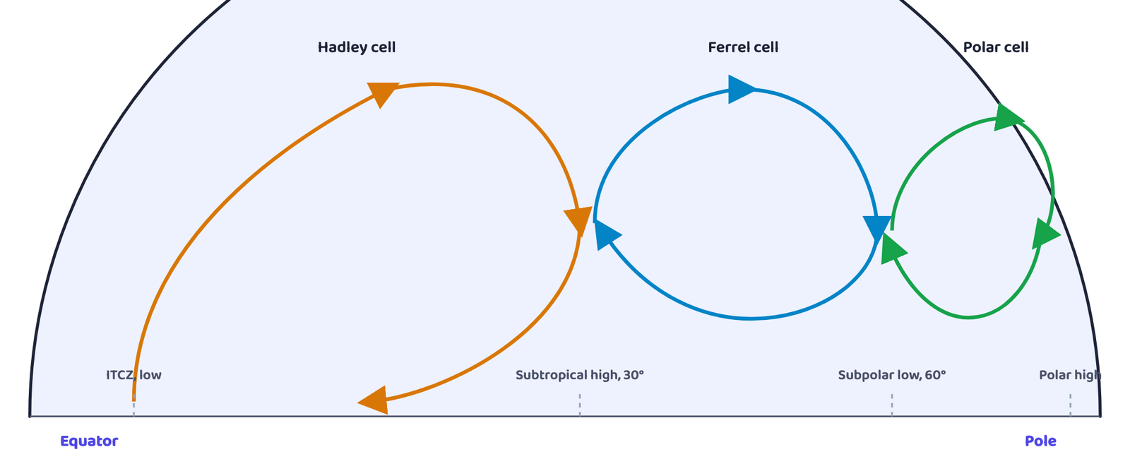
At the Inter Tropical Convergence Zone (ITCZ), air rises because of convection caused by high insolation, reaches the top of the troposphere at about 14 km, and moves towards the poles; this causes an accumulation of air at about 30°N and S. Two things cause this accumulated air to sink there and form the subtropical high: first, the sheer accumulation of air arriving from the ITCZ has to descend somewhere, and second, the air cools on reaching these latitudes, which also makes it sink. Part of this sinking air flows back towards the equator near the surface as the easterlies, closing the Hadley cell. In the middle latitudes the Ferrel cell has the westerlies at the surface, and at polar latitudes the cold dense air subsides near the poles and blows towards the middle latitudes as the polar easterlies (the polar cell).
Q. Why does tropical cyclone originate over the seas? In which part of the tropical cyclone do torrential rains and high velocity winds blow and why?
Answer: Tropical cyclones originate over warm tropical oceans because their energy comes from the condensation process in the towering cumulonimbus clouds surrounding the storm’s centre, which needs a continuous supply of moisture and heat from a warm sea surface (above 27°C) to strengthen the storm; once the storm reaches land this moisture supply from the sea is cut off, so the storm dissipates instead of intensifying (it peters out on the land). Torrential rain and the highest velocity winds (up to 250 km per hour) occur in the eye wall, the region immediately surrounding the calm central eye, because this is where there is a strong spiralling ascent of air to a great height, reaching the tropopause; this intense, concentrated uplift is what produces both the extreme wind speeds and the torrential rainfall.
4 In-text activity from the chapter
The chapter also gives this activity inside the text, in the opening section on atmospheric pressure.
Q. Consult your book, Practical Work in Geography, Part I (NCERT, 2006) and learn about these instruments.
Answer: “These instruments” are the two used to measure atmospheric pressure: the mercury barometer and the aneroid barometer. This chapter only names them; how each one works is explained in the Practical Work in Geography book, so read that section there. Remember from this chapter that pressure is expressed in millibars (as in the book’s pressure-distribution figures), that it decreases with height, and that its variation from place to place is the primary cause of wind.
(i) Collect weather information over media such as newspaper, TV and radio for understanding the weather systems. (ii) Read the section on weather in any newspaper, preferably one having a map showing a satellite picture; mark the area of cloudiness, infer the atmospheric circulation from the distribution of clouds, compare the newspaper’s forecast with TV coverage, and estimate how many days in a week the forecast was accurate. These are open-ended, activity-based exercises with no single fixed answer — carry them out over one week and record your own observations.
For Question 1(i) and Table 9.1, memorise that pressure falls by about 1 mb per 10 m of height, and the exact sea-level figure of 1,013.25 mb. For Question 3(ii), the chapter’s diagram answer, be able to name and describe all three cells (Hadley, Ferrel, polar) in order, and explain both reasons for the subtropical high at 30°N/S.
1. Pressure at 1 km above a 1,000 mb surface (Q1-i): about 900 mb. 2. Where the ITCZ occurs (Q1-ii): near the Equator. 3. Wind direction around a low in the northern hemisphere (Q1-iii): anticlockwise. 4. A source region for air masses (Q1-iv): the Siberian Plain. 5. Where torrential rain and the highest wind speed occur in a tropical cyclone (Q3-iii): the eye wall. Learn these word for word.