- Why the atmosphere has pressure at all, and how it changes with height and across the globe
- The three forces that decide which way the wind blows and how fast
- What a geostrophic wind is, and the rule that fixes the spin direction of every cyclone
- How three giant circulation cells move air, and heat, from the equator to the poles
- What an air mass and a front are, and why fronts only form in the middle latitudes
- How a tropical cyclone is built, from its calm eye to its destructive eye wall
- How thunderstorms turn into tornadoes, and why both are over almost as soon as they start
1Atmospheric Pressure
Every chair you sit on, every breath you take, happens under a sea of air pressing down on you. That press of air has a name and a measurable value.
Atmospheric pressure is the weight of a column of air contained in a unit area, from mean sea level to the top of the atmosphere. It is expressed in units of millibar (mb), and the average pressure at sea level is 1,013.25 mb.
Air near the surface is denser, because gravity pulls the whole weight of the atmosphere down onto it, so surface pressure is the highest pressure anywhere in the column. Pressure is measured with a mercury barometer or an aneroid barometer, and it always decreases as you go up, though not at the same rate throughout.
1.1 Vertical variation of pressure
In the lower atmosphere, pressure falls rapidly with height, by roughly 1 mb for every 10 m of elevation gained.
| Level | Pressure (mb) | Temperature (°C) |
|---|---|---|
| Sea level | 1,013.25 | 15.2 |
| 1 km | 898.76 | 8.7 |
| 5 km | 540.48 | −17.3 |
| 10 km | 265.00 | −49.7 |
The vertical pressure gradient force is actually much larger than the horizontal one that drives wind. It just gets cancelled almost exactly by gravity pulling the other way, which is why the atmosphere does not go rushing upward and off into space.
1.2 Horizontal distribution of pressure and the world pressure belts
Wind direction and speed are extremely sensitive to even small differences in pressure across the map. To study this, pressure readings are first reduced to sea level (to remove the effect of altitude), and then joined up on a weather map.
An isobar is a line joining places having equal atmospheric pressure, drawn after reducing each station’s reading to sea level. A low-pressure system is enclosed by one or more isobars with the lowest pressure at the centre; a high-pressure system is enclosed by isobars with the highest pressure at the centre.
The world’s sea-level pressure sorts itself into four belts, which shift a little with the seasons but never disappear.
| Pressure belt | Approx. location | Type |
|---|---|---|
| Equatorial low | Near the equator | Low |
| Subtropical highs | Along 30°N and 30°S | High |
| Subpolar lows | Along 60°N and 60°S | Low |
| Polar highs | Near the poles | High |
- They are NOT fixed in place, they oscillate with the sun’s apparent movement
- In the northern hemisphere, the belts shift south in winter and north in summer
2Forces Affecting the Velocity and Direction of Wind
Air set in motion by pressure differences is called wind, and it always tries to flow from high pressure to low pressure. But three forces, working together, decide exactly how fast and in what direction it actually moves.
2.1 The three forces
Pressure Gradient Force
The rate of change of pressure with distance. It is strong where isobars are packed close together, and weak where they are spread far apart.
Frictional Force
Slows the wind down. It is greatest at the surface, reaches up to about 1-3 km, and is minimal over the open sea.
Coriolis Force
The force caused by the earth’s own rotation, described by a French physicist in 1844.
The Coriolis force is the deflecting force caused by the rotation of the earth about its axis. It turns wind to the right in the northern hemisphere and to the left in the southern hemisphere, and it is directly proportional to latitude, maximum at the poles and completely absent at the equator.
Students often assume cyclones can form anywhere warm enough. But at the equator, the Coriolis force is exactly zero, so wind simply blows straight into a low pressure area, perpendicular to the isobars, and fills it up instead of letting it spin and intensify. That is precisely why tropical cyclones never form right at the equator.
Gravitational force also acts on the air, but always straight downward, so it does not affect wind direction the way the other three do.
3Pressure and Wind
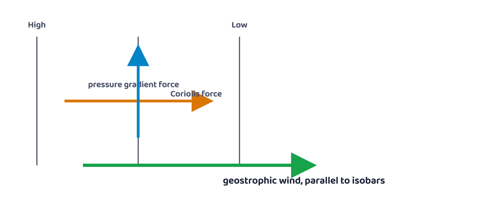
High above the friction layer, 2-3 km up, wind is controlled only by the pressure gradient force and the Coriolis force. When the two exactly balance, something very specific happens.
A geostrophic wind is a wind that blows parallel to straight isobars, produced when the pressure gradient force is exactly balanced by the Coriolis force, with no friction acting on it.
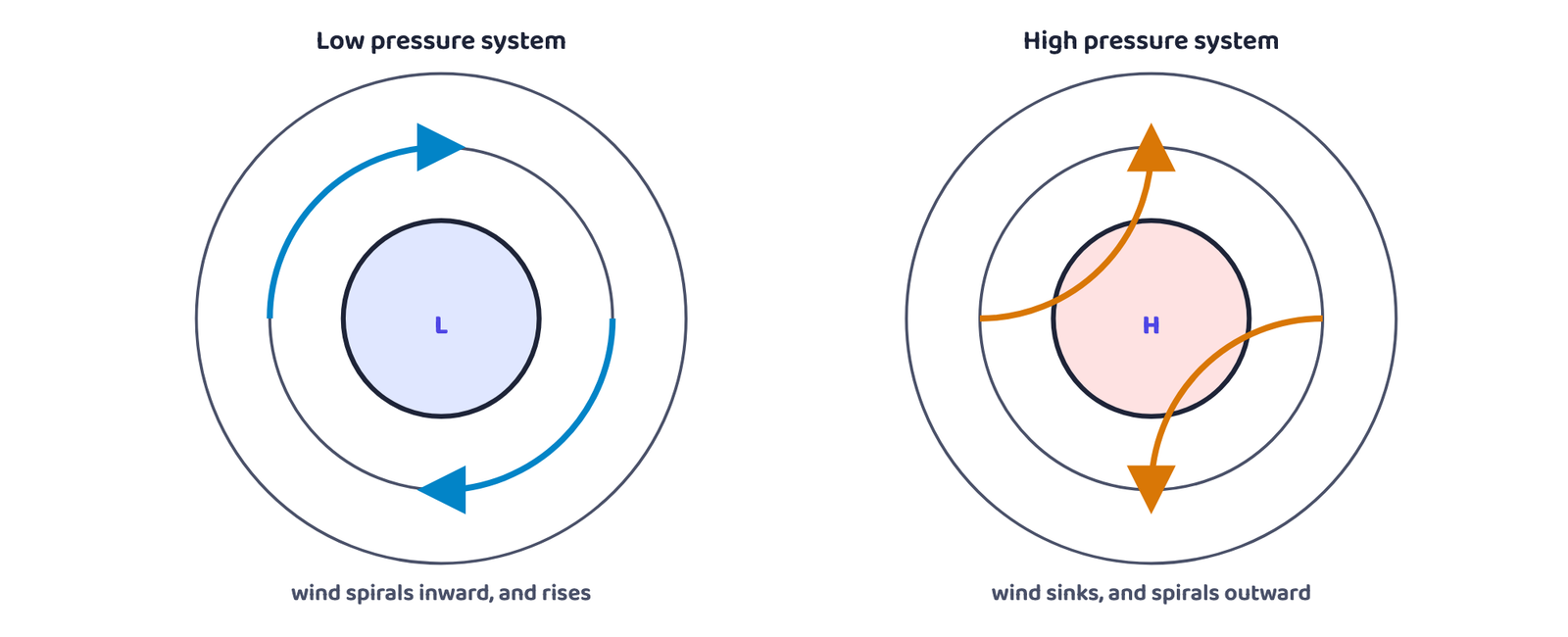
Cyclonic circulation is the wind circulation around a low pressure system; anticyclonic circulation is the wind circulation around a high pressure system.
| System | Pressure at centre | Northern hemisphere | Southern hemisphere |
|---|---|---|---|
| Cyclone | Low | Anticlockwise | Clockwise |
| Anticyclone | High | Clockwise | Anticlockwise |
Low = rising air = convergence. High = sinking air = divergence.
Over a low, air converges at the surface and rises; over a high, air sinks from above and diverges at the surface. Rising air is what eventually forms clouds and rain, which is exactly why “low pressure” is the phrase every weather bulletin treats as bad news.
4General Circulation of the Atmosphere
The general circulation of the atmosphere is the worldwide pattern of planetary wind movement. It depends on five things: latitudinal variation in heating, the pressure belts, their seasonal migration with the sun, the layout of continents and oceans, and the rotation of the earth.
Picture the atmosphere as three great rings of moving air stacked between the equator and each pole. Warm air rises at the Inter Tropical Convergence Zone (ITCZ), where converging tropical winds and high insolation force a low-pressure belt to form, and the air climbs all the way to about 14 km before spreading towards the poles.
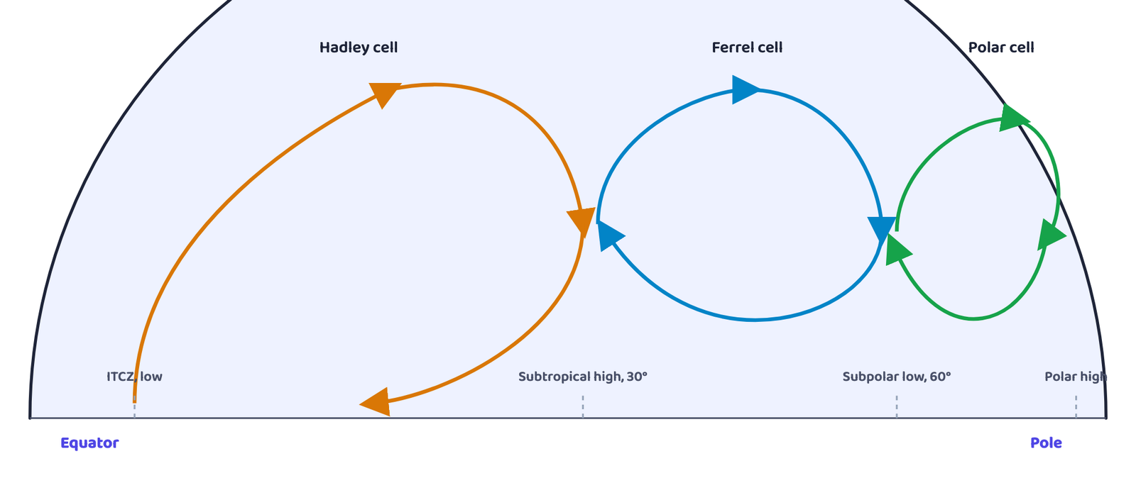
| Cell | Location | What happens | Surface wind |
|---|---|---|---|
| Hadley cell | Tropics | Air rises at the ITCZ, moves poleward aloft, sinks at 30°N/S as the subtropical high | Easterlies (surface air flows back to the equator) |
| Ferrel cell | Middle latitudes | Warm air rises from the subtropical high, cold air sinks from the poles | Westerlies |
| Polar cell | High latitudes | Cold, dense air subsides near the pole and spreads toward the middle latitudes | Polar easterlies |
“Draw a simplified diagram of the general circulation of the atmosphere” is asked almost every year for 5 marks. Practise Figure 3 until you can draw the three cells and label the ITCZ, subtropical high, subpolar low and polar high without looking.
4.1 El Niño, the Southern Oscillation and ENSO
El Niño
Warm water from the central Pacific slowly drifts toward the South American coast, replacing the normally cool Peruvian current off Peru.
Southern Oscillation
The linked change in pressure over the Central Pacific and Australia that accompanies El Niño.
ENSO
The combined El Niño + Southern Oscillation phenomenon. Strong ENSO years bring heavy rain to the arid South American west coast, drought in Australia (and sometimes India), and floods in China. It is closely monitored for long-range weather forecasting.
5Seasonal and Local Winds
The general circulation is not frozen in place all year, it shifts with the seasons as the zone of maximum heating moves. The most dramatic example of such a shift is the monsoon over southeast Asia, covered in detail in India: Physical Environment. Beyond that seasonal shift, several purely local winds are caused by the daily and yearly heating-and-cooling cycle of the land itself.
5.1 Four local winds
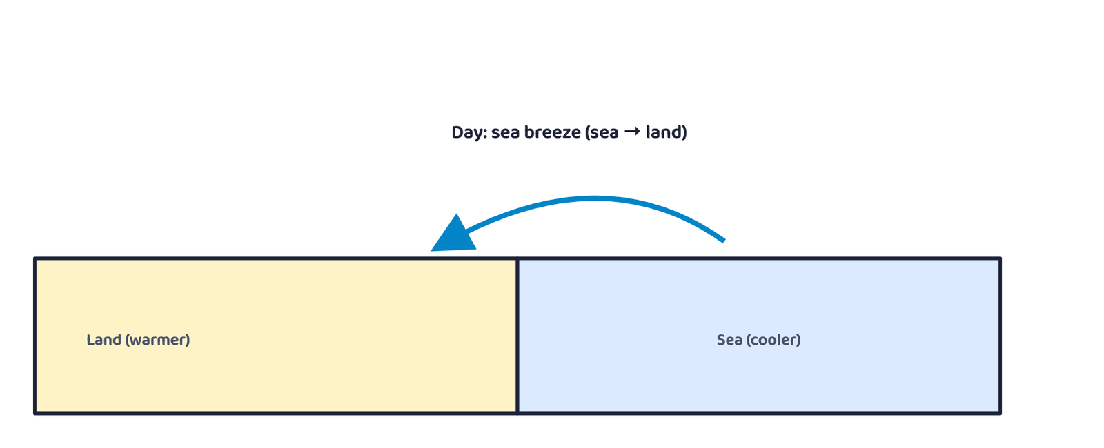
Sea breeze / Land breeze
By day the land heats faster than the sea, creating low pressure over land, so wind blows sea → land (sea breeze). By night the land cools faster, reversing the gradient, so wind blows land → sea (land breeze).
Valley wind / Mountain wind
By day, heated slopes push air upslope and valley air rises to replace it (valley breeze). By night, cooled slopes send dense air sinking back down into the valley (mountain wind).
Katabatic wind
Cold air draining downhill from high plateaus and ice fields into a valley.
Warm leeward wind
Moist air loses its moisture as rain while crossing a mountain range, then warms further by the adiabatic process as it descends the dry leeward slope, warm enough to melt snow quickly.
6Air Masses
An air mass is a large body of air with little horizontal variation in temperature and moisture. It forms when air sits over a homogeneous surface, called the source region, long enough to take on that region’s characteristics.
| Source region | Air-mass type | Code |
|---|---|---|
| Warm tropical and subtropical oceans | Maritime tropical | mT |
| Subtropical hot deserts | Continental tropical | cT |
| Relatively cold, high-latitude oceans | Maritime polar | mP |
| Very cold, snow-covered continents, high latitudes | Continental polar | cP |
| Permanently ice-covered continents (Arctic / Antarctica) | Continental arctic | cA |
7Fronts
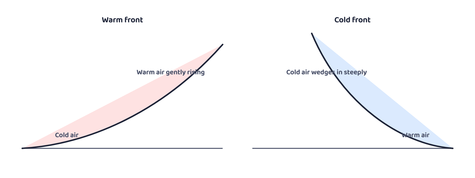
A front is the boundary zone where two different air masses meet. The process by which a front forms is called frontogenesis. Fronts occur only in the middle latitudes, are marked by a steep gradient in temperature and pressure, and bring abrupt temperature change, rising air, cloud and rain.
| Front | What happens |
|---|---|
| Cold front | The cold air mass moves aggressively toward the warm air mass |
| Warm front | The warm air mass moves toward the cold air mass |
| Stationary front | The front stays in place, neither air mass advances |
| Occluded front | An air mass is fully lifted off the land surface |
8Cyclones
8.1 Extra Tropical Cyclones
Extra tropical cyclones develop in the middle and high latitudes, along the polar front, far from the tropics.
| Feature | Extra tropical cyclone | Tropical cyclone |
|---|---|---|
| Frontal system | Clear warm + cold fronts | No frontal system at all |
| Where it forms | Over land or sea | Only over warm seas |
| Area covered | Larger | Smaller, but far more intense |
| Wind velocity | Lower, less destructive | Much higher, more destructive |
| Direction of movement | West to east | East to west |
8.2 Tropical Cyclones
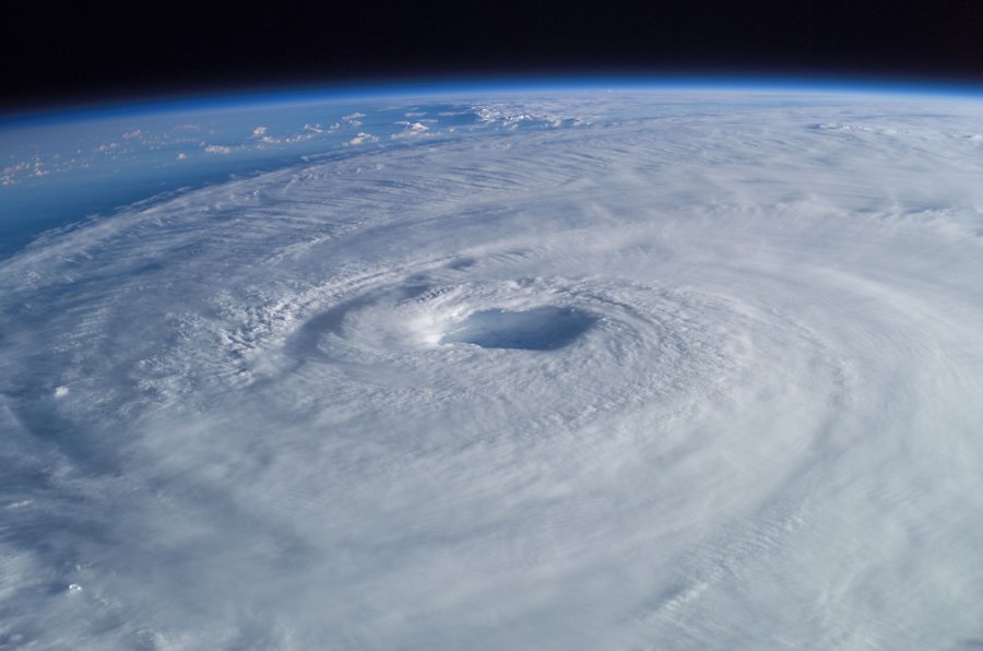
Tropical cyclones are violent storms that form over tropical oceans and move onto coasts, bringing large-scale destruction through violent winds, very heavy rain and storm surges.
| Ocean / Region | Local name |
|---|---|
| Indian Ocean | Cyclones |
| Atlantic | Hurricanes |
| Western Pacific and South China Sea | Typhoons |
| Western Australia | Willy-willies |
- A large sea surface with temperature higher than 27°C
- Presence of the Coriolis force (which is why they never form at the equator)
- Small variation in wind speed with height
- A pre-existing weak low-pressure area or low-level cyclonic circulation
- Upper-level divergence above the developing system
Landfall is the place where a tropical cyclone crosses the coast. Cyclones that cross 20°N latitude generally recurve and become more destructive.
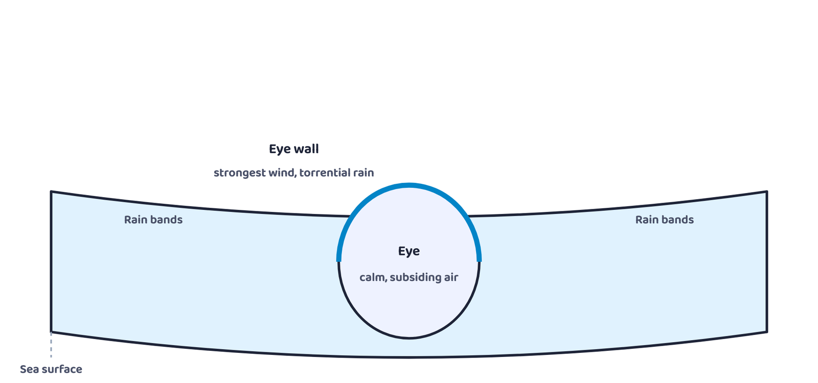
Do not confuse the eye with the eye wall. The eye is the calm centre with sinking air and almost no wind; the eye wall around it is where the wind is strongest and the rain is heaviest. A ship or coast passing straight through the eye briefly experiences an eerie calm between two spells of violent weather.
9Thunderstorms and Tornadoes
Thunderstorms and tornadoes are short-lived, cover only a small area, but are extremely violent while they last.
A thunderstorm is a well-grown cumulonimbus cloud, caused by intense convection on moist, hot days, that produces thunder and lightning. If insufficient moisture is available, the same convection produces a dust storm instead of rain.
A tornado is a violently spiralling, funnel-shaped column of wind descending from a severe thunderstorm, with extremely low pressure at its centre, causing massive destruction along its path. Tornadoes generally occur in the middle latitudes; a tornado that forms over the sea is called a waterspout.
Every violent storm in this chapter, thunderstorm, tornado, tropical cyclone, is really the atmosphere doing the same job at different scales: converting stored heat and potential energy into the kinetic energy of wind, then settling back into a calmer, more stable state.
- Atmospheric pressure (1,013.25 mb at sea level) decreases with height, about 1 mb per 10 m near the surface
- Four world pressure belts: equatorial low, subtropical highs (30°N/S), subpolar lows (60°N/S), polar highs, all shifting seasonally with the sun
- Wind results from three forces: pressure gradient force, frictional force and the Coriolis force (zero at the equator, maximum at the poles)
- A geostrophic wind blows parallel to straight isobars when pressure gradient force and Coriolis force exactly balance
- Cyclones (low) spin anticlockwise in the N. hemisphere and clockwise in the S. hemisphere; anticyclones (high) spin the opposite way
- General circulation runs on three cells: Hadley (tropics), Ferrel (mid-latitudes), polar, linked by the ITCZ, subtropical high, subpolar low and polar high
- Air masses are classified by source region into mT, cT, mP, cP and cA types; fronts (cold, warm, stationary, occluded) form only where two air masses meet, in the middle latitudes
- Extra tropical cyclones have clear fronts and move west to east; tropical cyclones have no fronts, form only over seas warmer than 27°C, and move east to west
- A tropical cyclone’s eye is calm; its surrounding eye wall carries the strongest wind (up to 250 km/h) and heaviest rain
- Thunderstorms and tornadoes are short-lived and small in area but extremely violent; a tornado over the sea is a waterspout
- 1 markIf the surface air pressure is 1,000 mb, the air pressure at 1 km above the surface will be:
(a) 700 mb(b) 1,100 mb(c) 900 mb(d) 1,300 mb - 1 markThe Inter Tropical Convergence Zone normally occurs:
(a) near the Equator(b) near the Tropic of Cancer(c) near the Tropic of Capricorn(d) near the Arctic Circle - 1 markThe direction of wind around a low pressure system in the northern hemisphere is:
(a) clockwise(b) perpendicular to isobars(c) anticlockwise(d) parallel to isobars - 1 markWhich one of the following is a source region for the formation of air masses?
(a) the Himalayas(b) the Siberian Plain(c) the Deccan Plateau(d) the Western Ghats - 1 markThe Coriolis force is:
(a) maximum at the equator, zero at the poles(b) zero at the equator, maximum at the poles(c) constant everywhere on earth(d) present only in the northern hemisphere - 1 markA wind blowing parallel to straight isobars, with the pressure gradient force balanced by the Coriolis force, is called:
(a) katabatic wind(b) geostrophic wind(c) land breeze(d) polar easterly - 1 markTropical cyclones in the Western Pacific and South China Sea are known as:
(a) Hurricanes(b) Willy-willies(c) Typhoons(d) Cyclones - 1 markFronts (cold, warm, stationary and occluded) are typically found in:
(a) the equatorial belt(b) the middle latitudes(c) the polar regions only(d) the subtropical deserts
Reason (R): The Coriolis force is zero at the equator, so a low pressure area there fills up instead of intensifying into a spinning system.
Reason (R): A cold front is steeper and pushes warm air upward faster than a warm front’s gentle slope does.
Reason (R): Extra tropical cyclones have no frontal system, while tropical cyclones do.
- 1 markDefine atmospheric pressure. In what unit is it measured?
- 1 markWhat is an isobar?
- 1 markName the three forces that together decide the direction and speed of surface wind.
- 1 markWhat is a geostrophic wind?
- 1 markName the three cells of the general circulation of the atmosphere.
- 1 markWhat is frontogenesis?
- 1 markWhat is landfall?
- 1 markWhat is a waterspout?
- 3 marksWhat is the unit used in measuring pressure? Why is station-level pressure reduced to sea level before preparing a weather map?
- 3 marksWhile the pressure gradient force in the northern-hemisphere tropics runs north to south, why do the surface winds there actually blow as north-easterlies?
- 2 marksWhat are geostrophic winds?
- 3 marksExplain how the land breeze and the sea breeze form, and why they blow in opposite directions.
- 3 marksDistinguish between cyclonic and anticyclonic circulation, in both hemispheres.
- 2 marksWhat is an air mass? Name its five recognised types.
- 3 marksDifferentiate between a cold front and a warm front.
- 2 marksState any two conditions favourable for the formation and intensification of a tropical cyclone.
- 3 marksDistinguish between the eye and the eye wall of a mature tropical cyclone.
- 2 marksWhat is a katabatic wind, and how is it different from a valley breeze?
- 5 marksDiscuss the factors affecting the speed and direction of wind.
- 5 marksDraw a simplified diagram to show the general circulation of the atmosphere over the globe. What are the possible reasons for the formation of a subtropical high pressure belt over 30°N and 30°S?
- 5 marksWhy does a tropical cyclone originate only over the seas? In which part of the tropical cyclone do torrential rain and the highest-velocity winds blow, and why?
- 5 marksExplain the formation of an extra tropical cyclone, from a stationary polar front to an occluded front.
- 5 marksCompare a tropical cyclone with an extra tropical cyclone under four heads: frontal system, place of origin, wind velocity and direction of movement.
- 5 marksExplain the concepts of air mass and front. Name and briefly describe the four types of fronts.