- What insolation actually is, and why the earth receives only a tiny slice of the sun’s total energy
- The three ways heat moves through the atmosphere, and which one matters most for your everyday weather
- How to read and explain the earth’s heat budget as one balanced 100-unit account
- The five factors that decide whether a place is hot or cold
- How to describe the January and July temperature patterns using isotherms, without needing a map
- What a temperature inversion is, and why it causes winter morning fog
1Solar Radiation
Every bit of heat on earth starts as sunlight. The sun’s energy reaches us mostly as short-wavelength radiation, and the earth’s surface receives most of its total energy this way. Scientists have a short, exact name for this incoming energy.
Insolation is the incoming solar radiation received by the earth, in the form of short waves.
The earth is a geoid (a sphere that bulges very slightly at the equator). Because it is round, the sun’s rays cannot fall straight down everywhere at once, they hit the top of the atmosphere at a slant over most of the globe. As a result the earth catches only a very small share of the sun’s total output: on average, just 1.94 calories per sq. cm per minute at the top of the atmosphere.
The sun’s own surface pours out energy in every direction, non-stop. The earth, being a small ball nearly 150 million km away, catches only a pinprick share of it, and even that pinprick is enough to power every wind, every rain shower and every season on the planet.
1.1 Aphelion and perihelion
The earth’s path around the sun is not a perfect circle, so its distance from the sun changes slightly through the year.
| Position | Date | Distance from sun | What it means |
|---|---|---|---|
| Aphelion | 4th July | 152 million km (farthest) | Earth is at its farthest point from the sun |
| Perihelion | 3rd January | 147 million km (nearest) | Earth is at its closest point to the sun |
A common one-mark question just swaps the dates and distances around to trick you. Remember it this way: “Perihelion is in January” (both start close together in the sound), and July is the opposite, aphelion.
Because the earth is slightly closer to the sun in January, it actually receives a little more annual insolation on 3rd January than on 4th July. But this small difference gets completely masked by bigger factors, the distribution of land and sea, and the general circulation of the atmosphere, so it has almost no effect on the daily weather you actually feel.
1.2 Why insolation is never the same everywhere
The amount and intensity of insolation change through the day, through the seasons, and from year to year. Five factors decide this, and the book is clear that the last two matter far less than the first three.
Rotation of the earth
The spinning earth means only half the globe faces the sun at any moment, giving day and night.
Angle of inclination of the sun’s rays
The single biggest factor, covered in detail below.
Length of the day
A longer day means more hours of insolation reaching the ground.
Transparency of the atmosphere
Clouds and dust cut down how much insolation actually gets through. (Less influence)
Configuration of land (aspect)
A slope facing the sun receives more insolation than one facing away. (Less influence)
1.3 The angle of the sun’s rays, the real reason polar regions are cold
The earth’s axis is tilted, it makes an angle of 66½° with the flat plane of its orbit around the sun. This tilt is the single biggest reason different latitudes receive such different amounts of insolation.
Here is the actual mechanism, and it is worth picturing carefully: the higher the latitude of a place, the smaller the angle its surface makes with the incoming rays, so the rays arrive more slanted rather than more overhead.
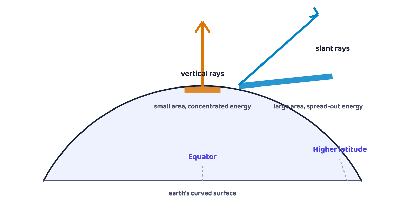
Two things happen together when rays turn slanted: the same energy now covers a bigger patch of ground, so the energy per unit area drops, and the slanted rays must also travel through a much greater thickness of atmosphere before they arrive, which means more of that energy is absorbed, scattered and diffused along the way. Both effects push in the same direction, less usable energy at higher latitudes.
2The Passage of Solar Radiation through the Atmosphere
The atmosphere is mostly see-through to incoming short-wave radiation, most of it passes straight through without being stopped. But not all of it.
2.1 What happens on the way through
Absorption
Inside the troposphere, water vapour, ozone and other gases absorb much of the near-infrared part of the incoming radiation.
Scattering
Very small suspended particles in the troposphere scatter the visible part of sunlight, some back to space, some down towards the earth’s surface.
Scattering is exactly why the sky has colour at all. The red glow of a rising or setting sun, and the blue of a clear daytime sky, are both the same process, sunlight bouncing off tiny particles in the air.
3Spatial Distribution of Insolation at the Earth’s Surface
Insolation actually received at ground level ranges from about 320 Watt/m² in the tropics down to only about 70 Watt/m² at the poles.
Students assume the equator gets the maximum insolation of anywhere on earth, because it is the “hottest” line on the globe. It does not. The book is precise: the subtropical deserts receive the maximum insolation, because their skies stay almost cloud-free all year. The equator actually receives comparatively less insolation than the tropics, since equatorial regions are far cloudier.
A few more patterns worth knowing exactly as the book states them:
- At the same latitude, land (continents) receives more insolation than the ocean
- In winter, the middle and higher latitudes receive less radiation than they do in summer
4Heating and Cooling of the Atmosphere
The atmosphere does not warm up on its own from sunlight passing through it. It is warmed mainly from below, by the earth’s surface, through three distinct processes.
4.1 The three heating processes
Conduction
Two bodies of unequal temperature touch, and heat flows from the warmer one to the cooler one until both reach the same temperature or the contact breaks. The air right next to the warmed ground heats slowly this way, and the layers above it heat in turn. Conduction is important only for warming the lower layers of the atmosphere.
Convection
Air in contact with the hot ground rises straight up as a current, carrying heat with it. This vertical heating is called convection, and it is confined only to the troposphere.
Advection
Heat transferred by the horizontal movement of air. In the middle latitudes, most of the day-to-day change in weather is caused by advection alone, it is more important than vertical movement for everyday weather. The hot, dry loo wind of summer in northern India is a well-known example of advection.
5Terrestrial Radiation and the Heat Budget
5.1 Terrestrial radiation
Terrestrial radiation is the long-wave energy radiated back into the atmosphere by the earth, after the earth itself has been heated by short-wave insolation.
This long-wave radiation is absorbed by atmospheric gases, mainly carbon dioxide and other greenhouse gases. That is the real order of events: the sun’s short-wave rays pass mostly straight through the air and warm the ground first, and the ground’s own long-wave radiation is what actually warms the atmosphere. In other words, the atmosphere is heated indirectly, by the earth, and not directly by the sun.
5.2 The heat budget, a balance sheet that always closes at zero
The heat budget (or heat balance) of the earth is the balance between the total insolation received by the earth and the total heat lost by it through terrestrial radiation, which is why the earth as a whole neither warms up nor cools down over time.
Picture the insolation reaching the top of the atmosphere as exactly 100 units. Every one of those 100 units is eventually accounted for, either reflected straight back, or absorbed and later re-radiated.
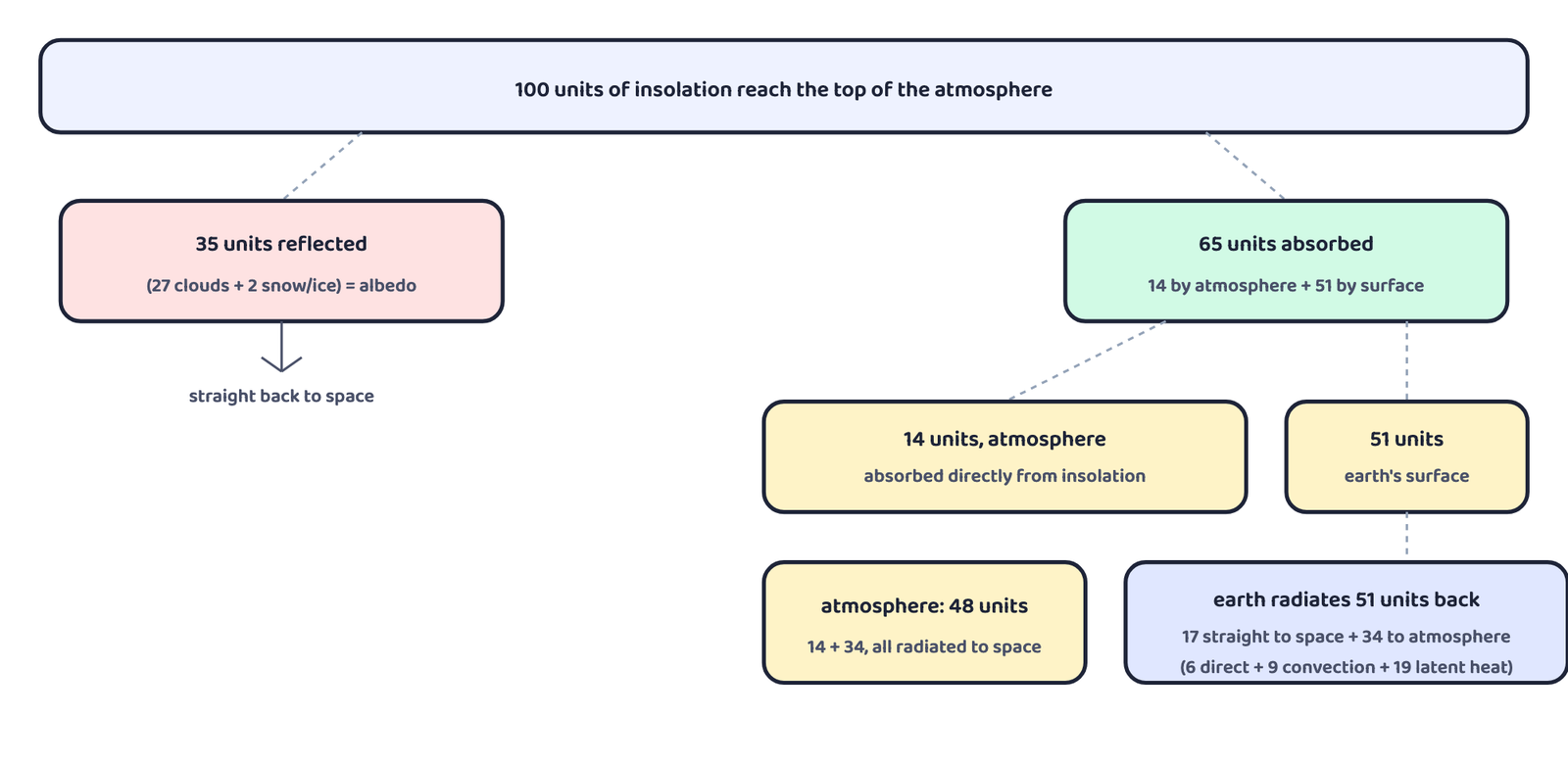
| Step | What happens | Units |
|---|---|---|
| Reflected before reaching the surface | 27 from cloud tops + 2 from snow/ice = albedo | 35 |
| Absorbed by the atmosphere | directly from incoming insolation | 14 |
| Absorbed by the earth’s surface | heats the ground | 51 |
| Earth’s surface radiates back | 17 straight to space + 34 to the atmosphere | 51 |
| Atmosphere’s 34 units split | 6 direct + 9 by convection/turbulence + 19 by latent heat of condensation | 34 |
| Total absorbed by atmosphere (radiated onward) | 14 (insolation) + 34 (terrestrial) = 48 | 48 |
| Total finally returned to space | 17 (direct) + 48 (from atmosphere) | 65 |
This diagram is asked almost every year for 5 marks. The number to hold onto is that 35 (reflected) + 65 (returned later as 17+48) = 100. That single equality is the whole answer to “why doesn’t the earth keep heating up forever?”
5.3 Where the surplus and deficit sit on the globe
The heat budget above is for the whole earth taken together. But no single latitude balances on its own, some places take in more radiation than they give back, and some give back more than they take in.
Surplus zone
Between 40°N and 40°S, the earth-atmosphere system receives more radiation than it loses.
Deficit zone
Near the poles, the system loses more radiation than it receives.
Redistribution
Winds and ocean currents carry the surplus heat from the tropics towards the poles, so the tropics never keep heating up and the poles never freeze completely solid.
6Temperature and the Factors Controlling Its Distribution
Temperature is the measurement, in degrees, of how hot or cold a thing or a place is. Heat is different, it represents the actual movement of the molecules making up a substance. The interaction of insolation with the atmosphere and the earth’s surface is what creates this heat, which we then measure as temperature.
6.1 Factors Controlling Temperature Distribution
The temperature of the air at any place is decided by five factors working together.
| Factor | How it works |
|---|---|
| Latitude | Temperature depends on insolation, and insolation itself varies with latitude, so temperature follows the same pattern |
| Altitude | The atmosphere is heated indirectly, from below, so places near sea level are warmer than places at high elevation. Temperature falls at the normal lapse rate of 6.5°C per 1,000 m |
| Distance from the sea | The sea heats up and cools down slowly, land heats up and cools down quickly. So places near the coast get a moderating sea/land-breeze effect and have a smaller temperature range than places inland |
| Air-mass and ocean currents | Places under warm air-masses or warm currents (like the Gulf Stream) record higher temperature; places under cold air-masses or cold currents record lower temperature |
| Local aspects | Local features of a place (its slope, surroundings) can raise or lower its temperature compared to nearby areas |
LAD-AL: Latitude, Altitude, Distance from sea, Air-mass/currents, Local aspects
All five factors work through the same two levers: how much insolation a place gets (latitude), or how quickly it loses the heat it gets (altitude, sea distance, currents, local aspects).
7Distribution of Temperature
7.1 Reading Isotherms
An isotherm is a line joining places that have equal temperature. Maps of world temperature are drawn using isotherms rather than colouring in every single value.
The clearest way to understand global temperature is to study the world’s temperature pattern in January and in July separately, since these two months show opposite seasons in the two hemispheres. In general, isotherms run roughly parallel to the lines of latitude, since latitude is the biggest single influence on temperature. But this neat pattern bends wherever land and ocean meet, and that bending is far more visible in January than in July, because the northern hemisphere has so much more land area than the southern hemisphere.
| Region | January pattern | Why |
|---|---|---|
| North Atlantic Ocean | Isotherms bend northward | Warm currents, the Gulf Stream and the North Atlantic Drift, keep the ocean warmer than its latitude alone would suggest |
| Europe / Siberian plain | Isotherms bend sharply southward | Land loses heat fast in winter; the effect is strongest in the Siberian interior |
| 60°E longitude, at 80°N and 50°N | Both record −20°C | Shows how far the winter cold spreads across the continental interior |
| Equatorial oceans | Above 27°C | Little seasonal change so close to the equator |
| Eurasian continental interior | −18°C to −48°C | Deep inside a huge landmass, far from the sea’s moderating effect |
| Southern hemisphere | Isotherms stay almost parallel to latitude, change is gradual | Much more ocean, far less land to disturb the pattern; the 20°C, 10°C and 0°C isotherms run close to 35°S, 45°S and 60°S |
| Region | July pattern |
|---|---|
| General trend | Isotherms run roughly parallel to latitude everywhere, the sharp January bends over Europe/Siberia disappear |
| Equatorial oceans | Above 27°C |
| Subtropical Asia, along 30°N | Above 30°C, the hottest land readings anywhere on the map |
| 40°N and 40°S | Both record about 10°C |
Do not draw or describe an actual outline map of any country in your answer, examiners want the isotherm behaviour explained in words, not a sketch of coastlines. Describe the pattern (parallel to latitude, bending north/south, region names) instead.
7.2 Annual Range of Temperature
The annual range of temperature is simply the gap between a place’s warmest month and its coldest month.
Continentality is the effect of being deep inside a large landmass, far from the sea’s moderating influence, which causes very hot summers and very cold winters, and so a very large annual range of temperature. It is the reason the north-eastern Eurasian continent records the highest annual range on earth.
8Inversion of Temperature
Normally, temperature falls as you go higher, this is the normal lapse rate you already met above. But sometimes this rule flips completely.
Temperature inversion is a reversal of the normal lapse rate, a situation where temperature actually increases with height instead of decreasing. It is usually short-lived but quite a common event.
Over the poles, this inversion is not an occasional event at all, it is normal all through the year.
8.1 What surface inversion does to a winter morning
A surface inversion makes the lower atmosphere very stable, air simply does not rise. Smoke and dust from chimneys and vehicles get trapped beneath the inversion layer instead of drifting upward, and spread out sideways to fill the lowest layer of air. This is exactly why dense fog is such a common sight on winter mornings, and it usually clears within a few hours once the rising sun starts warming the ground again.
8.2 Inversion in hills and valleys: air drainage
Air drainage is the flow of cold, dense air down a hill or mountain slope at night, under gravity, almost the way water flows downhill. This cold air collects in valley bottoms and low pockets, with a layer of comparatively warmer air resting above it.
Air drainage is actually useful to farmers. Because the coldest air sinks all the way down into the valley floor, it is the trees and plants growing on the slightly higher slopes, not those in the valley bottom, that stay warmer and escape frost damage.
Two boxed facts from the book are favourite one-mark questions. Planck’s law: the hotter a body is, the more energy it radiates, and the shorter the wavelength of that radiation. Specific heat: the energy needed to raise the temperature of one gram of a substance by one degree Celsius.
- Insolation is incoming short-wave solar radiation; the earth intercepts only a tiny share of it because it is a curved geoid
- Aphelion (4th July, farthest) and perihelion (3rd January, nearest) barely affect daily weather, other factors mask the difference
- Insolation varies mainly with the angle of the sun’s rays, controlled by the earth’s 66½° axial tilt
- Subtropical deserts, not the equator, receive the maximum insolation, because they have the least cloud cover
- Conduction heats the lowest air layers, convection heats vertically within the troposphere, advection (horizontal movement) drives most day-to-day weather change
- The atmosphere is heated indirectly, by the earth’s own long-wave terrestrial radiation, not directly by the sun
- The earth’s heat budget always balances: 35 units reflected, plus 65 units eventually radiated back (17+48), equal the 100 units received
- Five factors control temperature: latitude, altitude, distance from the sea, air-mass/currents, and local aspects
- Isotherms bend far more in January than in July because the northern hemisphere has so much more land
- Temperature inversion reverses the normal lapse rate, causes winter fog, and (via air drainage) protects hillside plants from frost
- 1 markThe sun is directly overhead at noon on 21st June at:
(a) The equator(b) 23.5° S(c) 23.5° N(d) 66.5° N - 1 markIn which of the following cities are the days the longest?
(a) Tiruvanantpuram(b) Chandigarh(c) Hyderabad(d) Nagpur - 1 markThe atmosphere is mainly heated by:
(a) Short-wave solar radiation(b) Reflected solar radiation(c) Long-wave terrestrial radiation(d) Scattered solar radiation - 1 markMatch the term with its meaning: (i) Insolation (ii) Albedo (iii) Isotherm (iv) Annual range, meaning (a) difference between warmest and coldest month’s mean temperature (b) lines joining places of equal temperature (c) incoming solar radiation (d) percentage of visible light reflected by an object
- 1 markThe main reason the subtropics record higher temperature than the equator is:
(a) Subtropical areas have less cloud cover than equatorial areas(b) Subtropical areas have longer summer days than equatorial areas(c) Subtropical areas have a stronger greenhouse effect(d) Subtropical areas are closer to the oceans - 1 markThe normal lapse rate of temperature is approximately:
(a) 5.5°C per 1,000 m(b) 6.5°C per 1,000 m(c) 7.5°C per 1,000 m(d) 9.8°C per 1,000 m - 1 markThe earth is farthest from the sun (aphelion) on:
(a) 3rd January(b) 21st June(c) 4th July(d) 22nd December - 1 markWhich of the following processes of heating is confined only to the troposphere?
(a) Conduction(b) Convection(c) Advection(d) Terrestrial radiation
Reason (R): At higher latitudes the sun’s rays are more slanting, spreading the same energy over a larger area.
Reason (R): Horizontal movement of air is relatively more important than vertical movement in the middle latitudes.
Reason (R): Isotherms in July generally run parallel to the latitude.
- 1 markDefine insolation.
- 1 markWhat is albedo?
- 1 markWhat is the normal lapse rate? State its value.
- 1 markDefine specific heat.
- 1 markWhat is an isotherm?
- 1 markName the two positions of the earth’s orbit when it is nearest and farthest from the sun.
- 1 markWhat is meant by the heat budget of the earth?
- 1 markName the local wind, caused by advection, that blows in northern India in summer.
- 3 marksDifferentiate between conduction and convection.
- 3 marksWhy do the subtropics record higher temperature than the equator?
- 3 marksState three factors that cause variability of insolation at the earth’s surface.
- 2 marksWhy is the annual range of temperature the highest in the interior of continents?
- 3 marksHow does distance from the sea affect the temperature of a place?
- 2 marksWhat causes the reddish colour of the sun at sunrise and sunset?
- 3 marksWhy is the atmosphere heated indirectly rather than directly by the sun?
- 2 marksState two effects of temperature inversion.
- 3 marksWhat is air drainage, and how does it protect plants from frost?
- 3 marksWhy do isotherms deviate more from their general east-west trend in January than in July?
- 5 marksWith the help of a labelled diagram, explain the heat budget of the earth.
- 5 marksExplain the three processes by which the atmosphere is heated and cooled.
- 5 marksDiscuss the factors that control the distribution of temperature on the earth’s surface.
- 5 marksDescribe the global pattern of temperature distribution in January.
- 5 marksWhat is temperature inversion? Explain the conditions favourable for its occurrence.
- 5 marksHow do latitude and the tilt of the earth’s axis affect the amount of insolation received at the surface?