- State the exact NCERT definition of map projection and explain why a globe alone is not enough
- List the four elements of map projection and the four global properties a projection tries to preserve
- Classify projections on all four bases: drawing technique, developable surface, global property, source of light
- Describe the properties, limitations and uses of the Conical, Cylindrical Equal Area, and Mercator’s projections
- Explain the Rhumb line (Loxodrome) and the Great Circle, and why navigators use each
1What Is Map Projection?
A globe is the most accurate model of the earth: because it is a
true 3-D shape, it shows the size, shape, direction and distance of every
continent and ocean correctly. But a globe has real limitations: it is
expensive, it cannot be carried everywhere easily, and it cannot show fine
local detail. The network of latitude and longitude lines that covers a
globe is called the graticule, and the whole problem this chapter
solves is: how do we get that graticule onto a flat sheet of paper we can
fold, print and carry?
Map projection is the method of transferring the graticule of
latitude and longitude onto a plane surface. It can also be defined as the
transformation of the spherical network of parallels and meridians onto a
plane surface.
On the globe, meridians are semi-circles and parallels are full circles.
The moment this curved network is transferred onto a flat surface, those
circles and semi-circles turn into intersecting straight lines or curved
lines — and that change is exactly where distortion creeps in.
A globe is not a substitute for a map. It has the property of
being a non-developable surface — it cannot be flattened
without shrinking, breaking or creasing. That single fact is the reason
map projection exists as a whole field of study.
2Need for Map Projection
Three practical problems push us from the globe to a flat, projected map:
Detailed regional study
A globe cannot show small areas in enough detail, and it is not easy
to compare two natural regions side by side on a curved surface.
Large-scale mapping
Drawing accurate, large-scale maps needs a flat sheet of paper —
a globe simply cannot be printed at that scale.
Distortion is unavoidable
Sticking a flat sheet on a globe will not fit without distortion over
a large area; light thrown from the globe’s centre creates a picture that
is more distorted the further it is from the point of contact.
Because the globe is a non-developable surface, some distortion in shape,
size, distance or direction is always inevitable. Cartographers have
devised many different methods to control where that distortion falls
and which property is protected — which is exactly what the rest
of this chapter classifies.
3Elements of Map Projection
Reduced Earth: a scaled-down model of the earth, represented on a
flat sheet of paper by a reduced scale. It is more or less spheroid, with
the polar diameter slightly less than the equatorial diameter, and it is
this model on which the graticule is transferred.
| Element | What it is |
|---|---|
| Parallels of latitude | Circles running round the globe parallel to the equator, at a uniform distance from the poles. Each lies in a plane at right angles to the earth’s axis. Unequal in length — a point at each pole, longest at the equator. Marked 0° to 90° North and South. |
| Meridians of longitude | Semi-circles running north-south from pole to pole; two opposite meridians together make one full circle (the globe’s circumference). Each lies in its own plane, but all intersect at right angles along the earth’s axis. The Greenwich meridian is the arbitrary reference, marked 0°. |
Every projection also has to decide which of four basic global
properties of the earth’s surface it will protect:
| # | Global property | What it means |
|---|---|---|
| i | Distance | Between any two given points of a region |
| ii | Shape | Of the region |
| iii | Size / Area | Of the region, kept accurate |
| iv | Direction | Bearing of one point of the region from another |
The single most repeated exam line in this chapter: no projection can
preserve all four global properties at the same time. Every
classification and every named projection in this chapter exists because of
that one fact — use it to open any long-answer question here.
4Classification of Map Projections
Map projections are classified on four completely independent
bases. A single real-world projection can be described using one label
from each column at once — for example, Mercator’s projection is
cylindrical (basis b), orthomorphic and azimuthal (basis c), and
mathematical (basis a), all together.
4.1 By drawing technique
Perspective
- Drawn using a source of light
- Projects the shadow of the graticule onto a developable surface
Non-perspective
- No light source or cast shadow used
- Developed geometrically, then flattened
Mathematical (conventional) projection: a projection derived
purely by mathematical computation and formulae, having little relation to
an actual projected shadow-image.
4.2 By developable surface
Developable surface: a surface that can be flattened without
shrinking, breaking or creasing. A globe (sphere) is non-developable;
a cylinder, a cone and a plane are all developable.
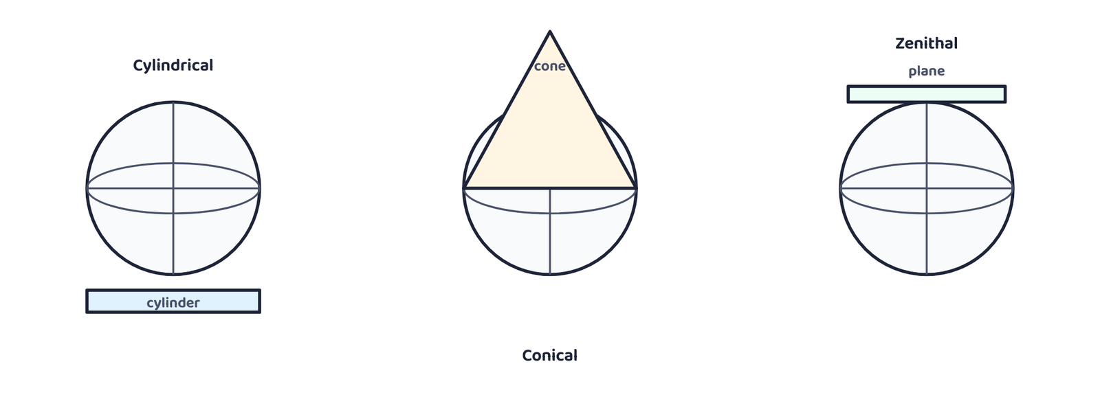
| Surface | How it is used | Result |
|---|---|---|
| Cylinder | A paper cylinder covers the globe; parallels and meridians are projected onto it | Cut the cylinder open → cylindrical projection |
| Cone | A cone is wrapped round the globe; the shadow of the graticule is projected onto it | Cut the cone open → conical projection |
| Plane | A flat plane touches the globe at one point, usually a pole; the graticule is projected directly | Obtained directly → zenithal (azimuthal) projection |
Zenithal projections are further divided by exactly where the plane
touches the globe:
4.3 By global property preserved
| Class | Also called | What it preserves | Trade-off |
|---|---|---|---|
| Equal Area | Homolographic | Correct area of every region | Shape is sacrificed |
| Orthomorphic | True-Shape | Correct shape of every region | Area is sacrificed |
| Azimuthal | True-Bearing | Correct direction of every point from the centre | Distance/area may be wrong |
| Equidistant | True-Scale | Correct distance/scale — but only along selected parallels or meridians, never everywhere | No projection keeps scale true throughout |
4.4 By source of light
| Projection | Where the light is placed |
|---|---|
| Gnomonic | At the centre of the globe |
| Stereographic | At the periphery, diametrically opposite the point where the plane touches the globe |
| Orthographic | At infinity, opposite the point where the plane touches the globe |
These four classifications are completely independent of each other.
Mercator’s projection, for instance, is cylindrical (basis 2),
orthomorphic and azimuthal (basis 3), and mathematical
(basis 1) — all at once. A projection’s full description usually
needs a label from more than one column.
5Three Selected Projections
NCERT constructs three named projections in detail. The geometric
construction itself (compass-and-ruler steps, scale arithmetic) belongs to a
practical map-work class; the properties, limitations and uses below are
what a written exam actually asks.
5.1 Conical Projection with One Standard Parallel
A cone is wrapped around the globe so that it touches along one particular
parallel of latitude — the standard parallel. The length of
every other parallel, on either side of it, comes out distorted.
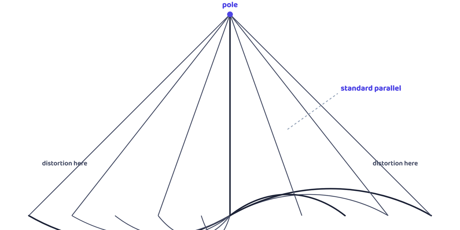
| Conical Projection with One Standard Parallel | |
|---|---|
| Properties | Parallels are arcs of concentric circles, equally spaced. Meridians are straight lines meeting at the pole, cutting parallels at right angles. Scale along meridians is true. The pole is shown as an arc, not a point. Scale is true only along the standard parallel, exaggerated away from it. Meridians converge towards the pole. Neither equal-area nor orthomorphic. |
| Limitations | Unsuitable for a world map — extreme distortion in the hemisphere opposite the standard parallel. Even within one hemisphere, unsuitable for very large areas because distortion is greater near the pole and near the equator. |
| Uses | Mid-latitude belts with limited latitudinal but large longitudinal extent. A long, narrow, east-west strip along the standard parallel is shown correctly — NCERT names the Canadian Pacific Railway, the Trans-Siberian Railway, the USA-Canada international boundary, and the Narmada Valley. |
5.2 Cylindrical Equal Area Projection (Lambert’s Projection)
A cylinder touches the globe at the equator, and parallel rays project the
graticule onto it. Both parallels and meridians come out as straight lines
crossing at right angles.
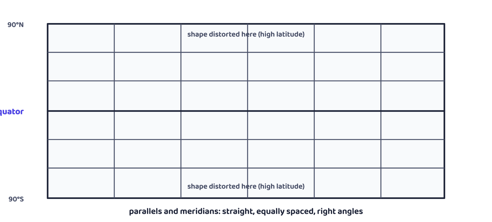
| Cylindrical Equal Area Projection | |
|---|---|
| Properties | All parallels and meridians are straight lines, intersecting at right angles. The polar parallel is shown equal in length to the equator. Scale is true only along the equator. |
| Limitations | Distortion increases towards the poles. Non-orthomorphic. Equality of area is maintained only at the cost of distortion in shape. |
| Uses | Best suited to the belt between 45°N and 45°S. Good for showing distribution of tropical crops — NCERT names rice, tea, coffee, rubber and sugarcane. |
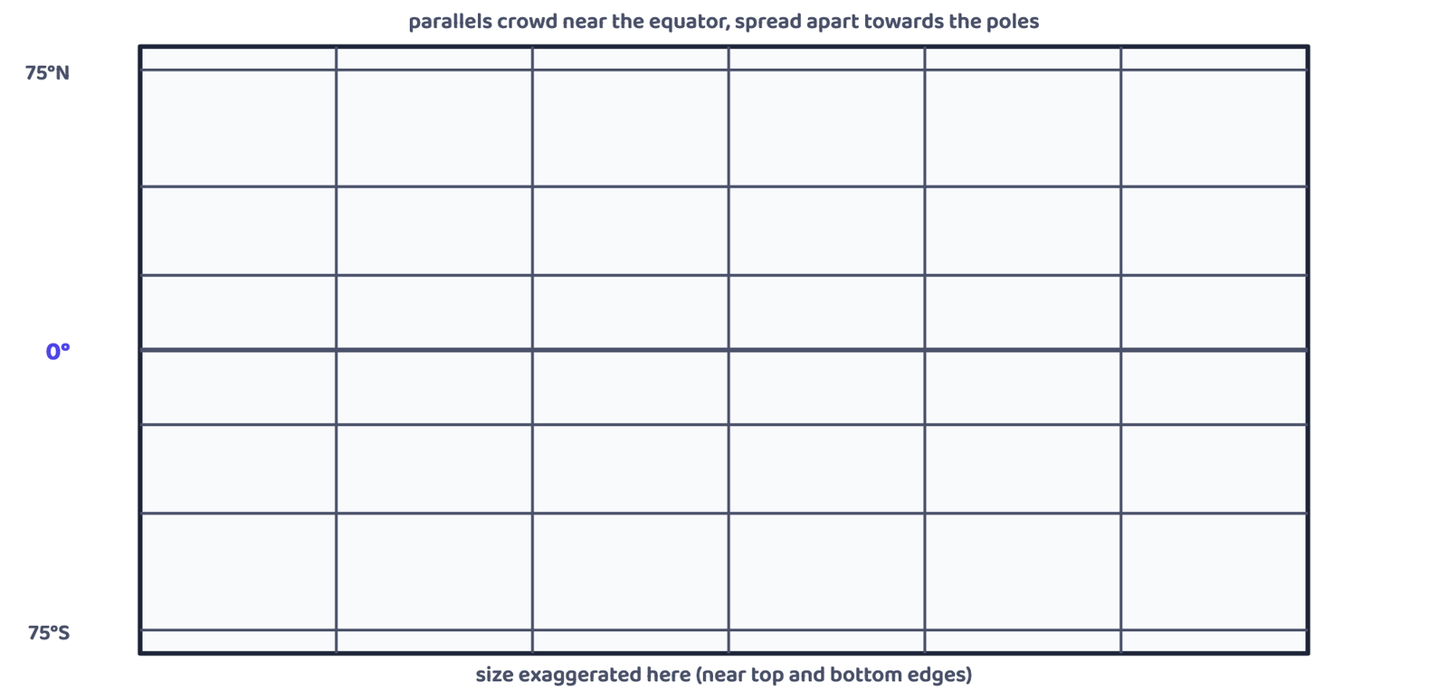
5.3 Mercator’s Projection
Developed by the Dutch cartographer Gerardus Mercator in 1569,
this is a mathematically constructed, orthomorphic (true-shape) projection.
Parallels and meridians are straight lines crossing at right angles, but
unlike the cylindrical equal-area projection, the spacing between parallels
keeps increasing towards the poles.
Loxodrome / Rhumb line: a straight line drawn on Mercator’s
projection joining any two points with a constant bearing, very useful for
determining direction during navigation.
Great Circle: the shortest route between two points on the
globe, shown as a curved line on Mercator’s projection. Used in both air
and ocean navigation.
| Mercator’s Projection | |
|---|---|
| Properties | Parallels and meridians are straight lines at right angles. All parallels are equal in length to the equator — NCERT’s own worked example: the 30° parallel comes out 1.154 times longer than its true length on the globe. All meridians are equal in length and spacing, longer than on the globe. Spacing between parallels increases poleward. Scale is correct only along the equator. Shape is preserved, but distorted at high latitudes; small countries near the equator keep true shape. It is both azimuthal and orthomorphic. |
| Limitations | Great exaggeration of scale at high latitudes — NCERT’s own example: Greenland appears the same size as the USA on this projection, though it is really only about one-tenth the size of the USA. The poles themselves cannot be shown, since the 90° parallel and the meridians touching it would be infinite. |
| Uses | World maps and atlases. Very useful for navigation, since a straight line (rhumb line) gives a constant compass bearing for sea and air routes. Also used to show drainage patterns, ocean currents, temperature, winds and world rainfall distribution. |
“Which projection is most useful for navigation, and why?” always wants
Mercator’s, with the reason being the rhumb line: a straight
line on this projection gives a constant bearing, which a ship or aircraft
can steer without constantly changing compass direction.
Do not confuse the Rhumb line (straight on Mercator’s projection,
constant bearing, but usually the longer real-world route) with the
Great Circle (curved on Mercator’s projection, but the actual
shortest route on the globe). Ships and aircraft often plot a route
close to the Great Circle for distance, but a Rhumb line is easier to
steer by compass.
6Comparing the Three Projections
| Basis | Conical (one std. parallel) | Cylindrical Equal Area | Mercator’s |
|---|---|---|---|
| Developable surface | Cone | Cylinder | Cylinder (mathematical) |
| Property preserved | Neither equal-area nor orthomorphic | Equal area (Homolographic) | Orthomorphic (true shape) and azimuthal |
| Scale true along | The standard parallel only | The equator only | The equator only |
| Best suited for | Narrow east-west mid-latitude strips (railways, boundaries) | The 45°N–45°S belt; tropical crop distribution | World maps, atlases, navigation |
| Named example used in NCERT | Trans-Siberian Railway, Narmada Valley | Rice, tea, coffee, rubber, sugarcane belts | Greenland vs USA size comparison |
- Map projection = transferring the graticule from the curved globe onto a flat surface. The globe is non-developable, so distortion is always unavoidable
- Elements: reduced earth, parallels of latitude, meridians of longitude, and four global properties (distance, shape, area, direction) — no projection preserves all four together
- Four independent classifications: technique (perspective/non-perspective/mathematical), developable surface (cylindrical/conical/zenithal), property preserved (equal area/orthomorphic/azimuthal/equidistant), light source (gnomonic/stereographic/orthographic)
- Zenithal projections sub-divide by point of contact: normal (equator), oblique (between pole and equator), polar (at the pole)
- Conical with one standard parallel: scale true only on the standard parallel; best for narrow mid-latitude east-west strips (railways, boundaries)
- Cylindrical Equal Area (Lambert’s): equal area at the cost of shape; best for the 45°N–45°S belt and tropical crops
- Mercator’s (Gerardus Mercator, 1569): orthomorphic + azimuthal; straight line = Rhumb line (constant bearing, used for navigation); Greenland looks the size of the USA though it is really 1/10th the size
- Great Circle = shortest real route (curved on Mercator’s); Rhumb line = constant-bearing route (straight on Mercator’s)
- Can I write the exact NCERT definition of map projection, word for word?
- Can I name all four global properties and state that no projection keeps all four?
- Can I classify a projection on all four bases at once, the way Mercator’s is classified in this chapter?
- Can I give the properties, one limitation and one named use for each of the three constructed projections?
- Can I explain the difference between a Rhumb line and a Great Circle in one sentence each?
- 1 markA map projection least suitable for a world map is:
(a) Mercator(b) Simple Cylindrical(c) Conical(d) All the above - 1 markA map projection that is neither equal area nor correct in shape, and even the directions are incorrect, is:
(a) Simple Conical(b) Polar Zenithal(c) Mercator(d) Cylindrical - 1 markA map projection with correct direction and correct shape, but area greatly exaggerated poleward, is:
(a) Cylindrical Equal Area(b) Mercator(c) Conical(d) All the above - 1 markWhen the source of light is placed at the centre of the globe, the resultant projection is called:
(a) Orthographic(b) Stereographic(c) Gnomonic(d) All the above - 1 markThe Cylindrical Equal Area Projection is also known as:
(a) Mercator’s Projection(b) Lambert’s Projection(c) Gnomonic Projection(d) Bonne’s Projection - 1 markMercator’s Projection was developed in the year:
(a) 1492(b) 1569(c) 1767(d) 1885 - 1 markA conical projection touches the globe along the:
(a) Prime meridian(b) Standard parallel(c) Equator only(d) International Date Line - 1 markA zenithal projection in which the plane touches the globe at the equator is called:
(a) Polar(b) Oblique(c) Normal / equatorial(d) Conical - 1 markWhich of these surfaces is developable?
(a) Sphere(b) Cone(c) Geoid(d) Globe - 1 markOn Mercator’s Projection, a straight line joining two points at a constant bearing is called a:
(a) Great Circle(b) Standard parallel(c) Rhumb line(d) Central meridian
Reason (R): The globe is a non-developable surface, which limits its use for large-scale, detailed mapping.
Reason (R): Mercator’s Projection greatly exaggerates the scale of areas at high latitudes.
Reason (R): The classification of projections by developable surface and by global property preserved are two completely independent bases.
- 1 markDefine map projection in one line.
- 1 markName the four global properties a map projection tries to preserve.
- 1 markWhat is a standard parallel?
- 1 markName the three sub-types of a zenithal projection based on where the plane touches the globe.
- 3 marksDescribe the elements of map projection.
- 3 marksWhat do you mean by “global property” in the context of map projection?
- 3 marksNo single map projection represents the globe truly. Why?
- 3 marksHow is area kept equal in the Cylindrical Equal Area projection?
- 3 marksDifferentiate between developable and non-developable surfaces.
- 3 marksDifferentiate between Homolographic and Orthomorphic projections.
- 3 marksDifferentiate between Normal and Oblique projections.
- 5 marksDiscuss the criteria used for classifying map projections, and state the major characteristics of each type.
- 5 marksWhich map projection is most useful for navigational purposes? Explain its properties and limitations.
- 5 marksDiscuss the main properties of a conical projection with one standard parallel, and describe its major limitations.
- 5 marksCompare the Conical, Cylindrical Equal Area and Mercator’s projections on the basis of developable surface, property preserved and typical use.