and Time
- Why the earth’s true shape makes an imaginary grid of lines necessary at all
- What parallels of latitude and meridians of longitude are, and how each is actually drawn
- Six clear differences between latitude and longitude, the kind examiners ask as one question
- How to calculate the local time of any place from its longitude, step by step
- Why a country adopts one Standard Meridian, and how India’s own Standard Time is calculated
- What the International Date Line is, and the rule for gaining or losing a calendar day when you cross it
1Why We Need a Grid
The earth is nearly a sphere, but not quite. Its equatorial radius and its polar radius are not the same, because the earth’s own rotation on its axis produces a bulge at the equator. The real shape is therefore called an oblate spheroid: very slightly flattened at the poles and slightly bulging at the equator.
This shape creates a real problem: there is no natural point on the earth’s surface from which the position of every other point can be measured. To solve this, an imaginary network of lines is drawn on a globe or a map, so that the location of any place can be fixed. This network is called the geographical grid.
The earth’s spin on its own axis, from west to east, gives two natural points of reference: the North Pole and the South Pole. These two points form the basis of the geographical grid, a network of two sets of intersecting lines: horizontal lines, called parallels of latitude, and vertical lines, called meridians of longitude.
“What are the two natural points of reference on the earth?” is asked almost every year in some form. The answer is exactly two words: North Pole and South Pole, nothing else.
2Parallels of Latitude
Latitude of a place is its angular distance north or south of the equator, measured along the meridian of that place, as an angle from the centre of the earth. A line joining all places with the same latitude is called a parallel.
Horizontal lines are drawn parallel to each other running east to west. The line exactly midway between the North Pole and the South Pole is the equator. It is the largest circle on the globe, divides it into two equal halves, and is also called a great circle. Every other parallel gets progressively smaller moving from the equator towards the poles, and divides the earth into two unequal halves, so every parallel other than the equator is called a small circle.
The equator is a great circle: the only parallel that is the largest possible circle on the globe and divides it into two exactly equal halves. Every other parallel is a small circle.
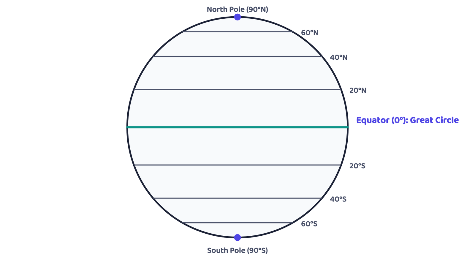
If the earth were a perfect sphere, one degree of latitude, that is, a one-degree arc of a meridian, would be a constant 111 km everywhere. But because the earth is an oblate spheroid, this length changes very slightly: it is 110.6 km at the equator and 111.7 km at the poles. The latitude of a place can be found with the help of the altitude of the sun or the Pole Star.
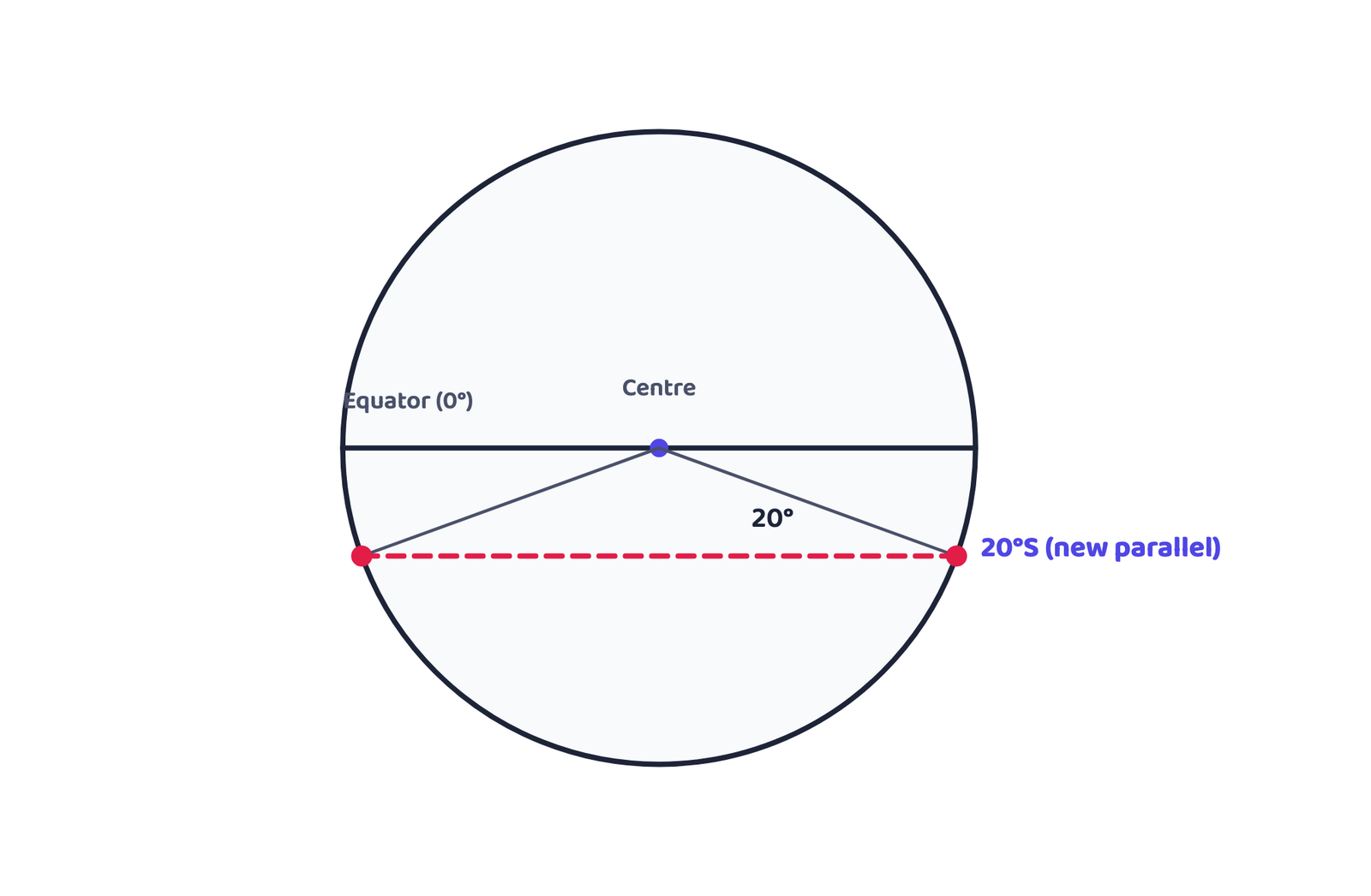
2.1 Drawing a Parallel of Latitude
Draw a circle and bisect it with a horizontal line through the centre: this line represents the equator. Place a protractor on the circle so that its 0° and 180° mark coincides with this equator line. To draw 20°S, mark two points at an angle of 20° from the equator, on the east and west sides, in the lower half of the circle. The two arms of this angle cut the circle at two points. Joining these two points with a line parallel to the equator gives the 20°S parallel.
3Meridians of Longitude
Longitude of a place is its angular distance east or west of the Prime Meridian, measured in degrees. A line joining all places with the same longitude is called a meridian.
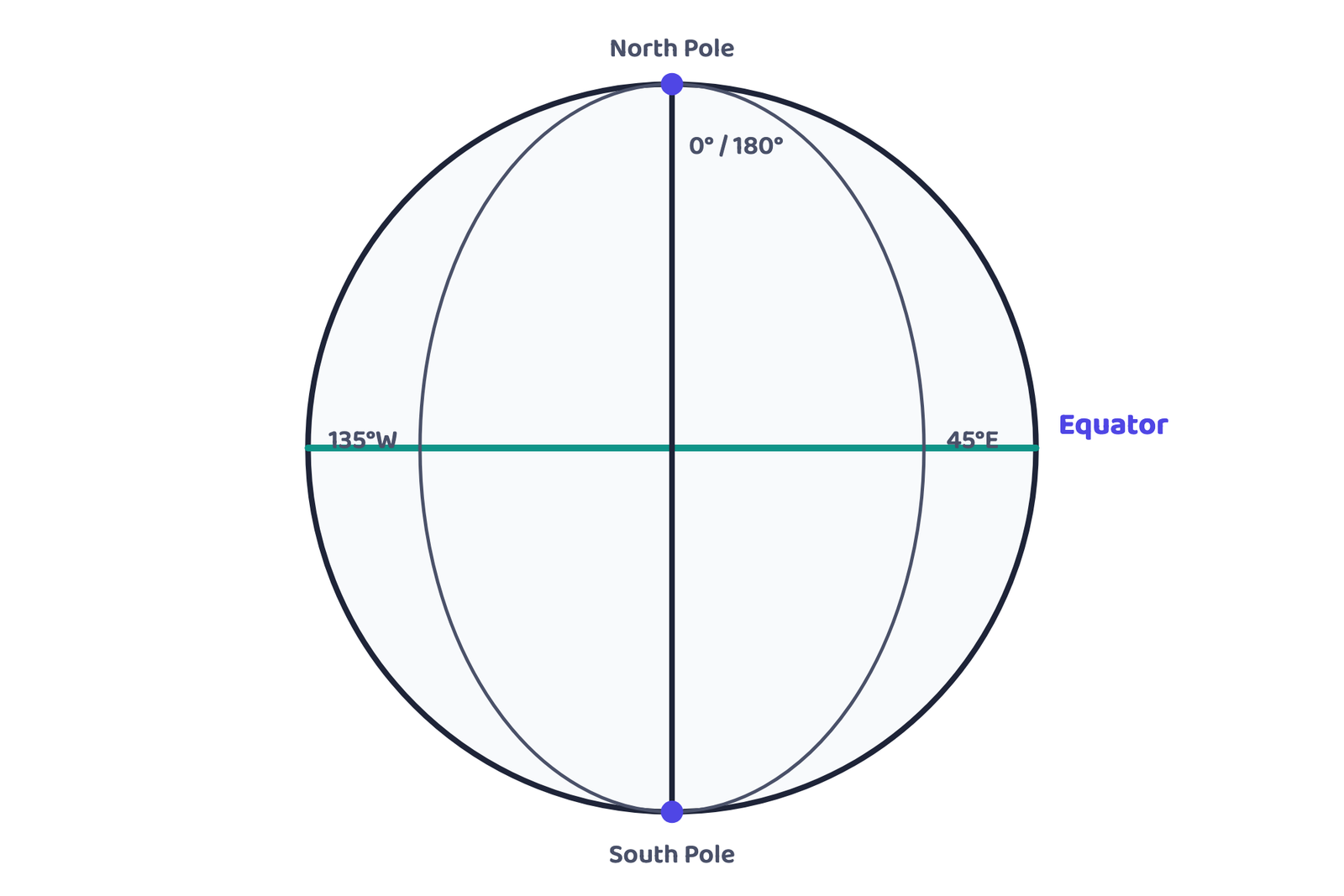
Unlike parallels of latitude, which are complete circles, meridians of longitude are semi-circles that converge at the poles. Two opposite meridians together make up a full circle, but they are always valued and named as two separate meridians, for example, 20°E and 160°W are opposite halves of the same great circle. Meridians intersect the equator at right angles, and unlike parallels, all meridians are equal in length.
The Prime Meridian is the meridian passing through the Greenwich Observatory, near London. It was adopted as the reference meridian by international agreement and given the value 0°. Longitude is measured from 0° to 180° both east and west of it. The part of the earth east of it is the Eastern Hemisphere; the part west of it is the Western Hemisphere.
3.1 Drawing the Meridians of Longitude
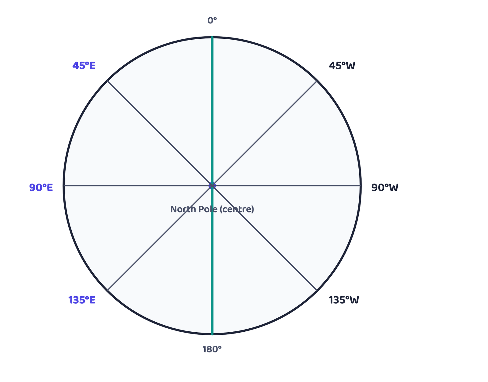
Draw a circle whose centre represents the North Pole; its circumference then represents the equator. Draw a vertical line through the centre: this represents the 0° and 180° meridians meeting at the North Pole.
On an ordinary map, east is to your right. But to draw longitudes, imagine yourself standing exactly at the North Pole, at the centre of the circle. From that viewpoint the directions reverse: east now appears to your left, and west appears to your right. This is why, in Figure 4 below, 45°E is drawn to the left of the 0°/180° line and 45°W to the right.
4Comparing Latitudes and Longitudes
This comparison is one of the most frequently asked questions on this chapter, exactly as the table below sets it out.
| Parallels of Latitude | Meridians of Longitude |
|---|---|
| Angular distance of a point north or south of the equator, measured in degrees. | Angular distance along the equator, measured in degrees east or west of Greenwich (0°), from 0° to 180°. |
| All latitudes are parallel to the equator. | All meridians converge at the poles. |
| On a globe, parallels of latitude appear as circles. | All meridians appear as circles running through the poles. |
| Distance between two latitudes is approximately 111 km, everywhere. | Distance between two longitudes is maximum at the equator (111.3 km), minimum at the poles (0 km), and 79 km midway, at 45°. |
| 0° latitude is the equator; 90° is the poles. | There are 360° of longitude in all: 180° each in the east and west of the Prime Meridian. |
| Latitudes are used to demarcate temperature zones. | Longitudes are used to determine local time, with reference to the time at the Prime Meridian. |
4.1 Heat Zones Based on Latitude
Torrid Zone
0° to 23½° north and south of the equator: the hottest zone, receiving the most direct sunlight all year.
Temperate Zone
23½° to 66½° north and south: moderate temperatures, with a clear change of seasons.
Frigid Zone
66½° to 90° north and south, right up to the poles: the coldest zone, receiving the least direct sunlight.
5Longitude and Local Time
The earth rotates on its axis from west to east. This is exactly why the sun appears to rise in the east and set in the west: the earth is turning to face the sun from the west side. One complete rotation, 360° of longitude, takes 24 hours. Since 180° of longitude lie on each side, east and west, of the Prime Meridian, the sun takes 12 hours to cross from the eastern hemisphere into the western hemisphere.
5.1 The Four-Step Method
Moving East of the Prime Meridian
- Local time is ahead of Greenwich
- Time increases as you go further east
- The time difference is added to Greenwich time
Moving West of the Prime Meridian
- Local time is behind Greenwich
- Time decreases as you go further west
- The time difference is subtracted from Greenwich time
East is fast, west is last.
Go east and your clock reading jumps forward (fast). Go west and it falls behind (last).
Given
Thimphu, Bhutan, is at 90°E. Time at Greenwich (0°) is 12:00 noon.
Find
Local time at Thimphu
Longitude difference between Greenwich and Thimphu = 90°
Total time difference = 90 × 4 = 360 minutes = 360 ÷ 60 = 6 hours
Thimphu is east of Greenwich, so this is added.
Local time at Thimphu = 12:00 noon + 6 hours = 6:00 p.m.
Given
New Orleans (badly hit by Hurricane Katrina, October 2005) is at 90°W. Time at Greenwich (0°) is 12:00 noon.
Find
Local time at New Orleans
Longitude difference between Greenwich and New Orleans = 90°
Total time difference = 90 × 4 = 360 minutes = 360 ÷ 60 = 6 hours
New Orleans is west of Greenwich, so this is subtracted.
Local time at New Orleans = 12:00 noon − 6 hours = 6:00 a.m.
6Standard Time and Time Zones
Calculating a different local time for every single longitude within one country would make daily life impossible: two towns 50 km apart would carry slightly different clocks. To avoid this, the local time of a country’s central meridian is adopted as its Standard Meridian, and this one time is used as the Standard Time for the entire country.
A country’s Standard Meridian is chosen so that it is divisible by 7°30′. This ensures the difference between the country’s Standard Time and Greenwich Mean Time (GMT) always works out to a clean multiple of an hour or half an hour.
Given
India’s Standard Meridian is 82°30′E, passing through Mirzapur.
Find
Indian Standard Time (IST), as a difference from GMT
(82°30′ × 4) ÷ 60 minutes = 330 ÷ 60 = 5 hours 30 minutes
82°30′E is east of Greenwich, so this is added.
IST = GMT + 5 hours 30 minutes, i.e. 5:30 hours ahead of GMT.
Countries with a large east-to-west span cannot fairly use just one Standard Meridian, since the local time at either end would differ too greatly from it. Such countries choose more than one standard meridian, giving them more than one time zone. The book names three: Russia, Canada, and the United States of America. Taken across the whole world, this system of standard meridians divides the earth into 24 major time zones.
7The International Date Line
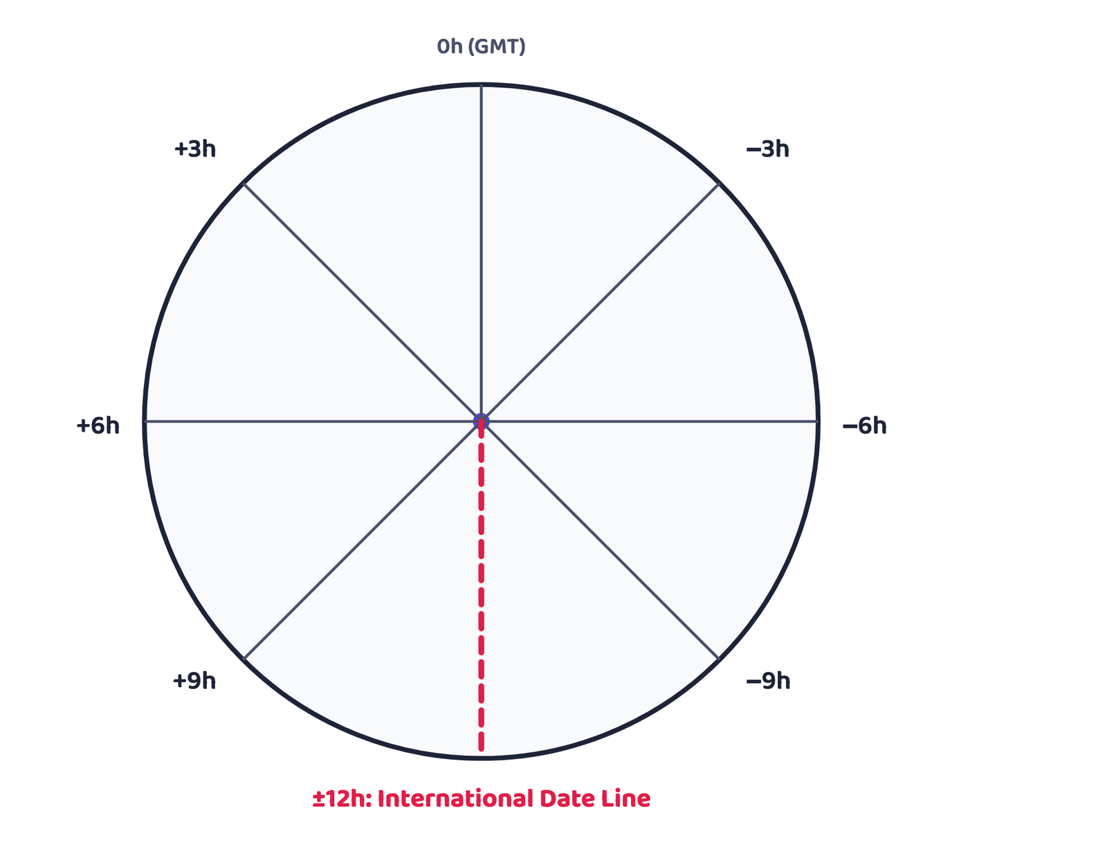
If the world is divided into 24 time zones, there must be one place on earth where the calendar date itself changes, where a new day truly “starts”. The 180° meridian is approximately where this line, the International Date Line (IDL), passes. The time at this meridian differs from the time at 0° longitude by exactly 12 hours, whether you reach it by travelling east or west.
The International Date Line is the line, approximately along the 180° meridian, where the calendar date changes by one full day. A traveller crossing it moving east puts the calendar back by one day; a traveller crossing it moving west moves the calendar forward by one day.
Since time increases east of the Prime Meridian and decreases west of it, a person who keeps moving east eventually reaches a point 12 hours ahead, while a person moving west eventually reaches a point 12 hours behind. Both are converging on the same line from opposite directions, which is why crossing it must correct the date, not just the clock.
This is exactly why a flight travelling east across the Pacific Ocean, crossing the International Date Line, can land its passengers on a calendar date earlier than the one they departed on, even though the actual flight time moved forward by many hours.
A person travelling eastward, starting on a Tuesday, counts the day as Monday once they cross the International Date Line.
Another person starting the same Tuesday but travelling westward counts the day as Wednesday once they cross it.
- Can I state the two natural points of reference on the earth, without hesitating?
- Can I explain why the equator is called a great circle and other parallels are small circles?
- Can I calculate the local time of a place from its longitude, showing every step?
- Can I explain why India uses a single Standard Meridian, and state its exact value?
- Can I state the rule for gaining or losing a day at the International Date Line, in both directions?
Try It Yourself: Reading an Atlas
The NCERT textbook itself sets this as an activity: using an atlas, find and write down the latitude and longitude of each of these places.
| Place | Latitude | Longitude |
|---|---|---|
| Mumbai | ||
| Vladivostok | ||
| Cairo | ||
| New York | ||
| Ottawa | ||
| Geneva | ||
| Johannesburg | ||
| Sydney |
Try It Yourself: Working Out World Time
The textbook’s own second activity: if the time at the Prime Meridian is 10:00 a.m., work out the standard time in each of these cities using their own country’s standard-time difference from GMT.
| City | Standard time difference from GMT | Time when GMT is 10:00 a.m. |
|---|---|---|
| Delhi | +5:30 | 3:30 p.m. |
| London | +0:00 | 10:00 a.m. |
| Tokyo | +9:00 | 7:00 p.m. |
| Paris | +1:00 | 11:00 a.m. |
| Cairo | +2:00 | 12:00 noon |
| Moscow | +3:00 | 1:00 p.m. |
- Earth is an oblate spheroid; its two natural reference points are the North Pole and the South Pole
- Equator = 0°, the only great circle; all other parallels are small circles; 179 parallels total at 1° intervals
- 1° of latitude ≈ 111 km, actually 110.6 km at the equator and 111.7 km at the poles
- Meridians are semi-circles, all equal in length, meeting at the poles, crossing the equator at right angles
- Prime Meridian = 0°, through Greenwich; longitude runs 0° to 180° east and west of it
- 1° of longitude = 4 minutes of time; 15° of longitude = 1 hour; east adds time, west subtracts it
- Standard Meridian must be divisible by 7°30′; India’s is 82°30′E through Mirzapur, giving IST = GMT + 5:30
- Large east-west countries (Russia, Canada, USA) use more than one time zone; the world has 24 in total
- International Date Line ≈ 180° meridian; crossing east subtracts a day, crossing west adds a day
- 1 markThe earth’s true shape is best described as:
(a) A perfect sphere(b) An oblate spheroid(c) A perfect cube(d) A flat disc - 1 markWhich of these is called a great circle?
(a) Tropic of Cancer(b) The Prime Meridian alone(c) The Equator(d) The Arctic Circle - 1 markThe total number of parallels of latitude, drawn at 1° intervals and including the equator, is:
(a) 90(b) 180(c) 179(d) 360 - 1 markThe Prime Meridian passes through the observatory at:
(a) Paris(b) Greenwich(c) Mirzapur(d) New York - 1 markOne degree of longitude equals how many minutes of time?
(a) 1 minute(b) 4 minutes(c) 15 minutes(d) 60 minutes - 1 markIndia’s Standard Meridian, 82°30′E, passes through:
(a) Delhi(b) Mumbai(c) Mirzapur(d) Chennai - 1 markThe International Date Line lies approximately along the:
(a) Equator(b) Prime Meridian(c) 90° meridian(d) 180° meridian - 1 markA traveller crossing the International Date Line while moving west must:
(a) Add one day(b) Subtract one day(c) Add twelve days(d) Make no change at all
Reason (R): The equator is the largest circle on the globe and divides it into two exactly equal halves.
Reason (R): Meridians are semi-circles that converge at the poles, and every one of them is exactly equal in length.
Reason (R): A country’s Standard Meridian is chosen so that its time difference from GMT works out to a clean multiple of an hour or half an hour.
- 1 markName the two natural points of reference on the earth.
- 1 markWhat is a great circle?
- 2 marksWhat are geographical coordinates?
- 2 marksWhy does the sun appear to move from east to west?
- 2 marksWhat is meant by local time?
- 1 markWhat value is given to the Prime Meridian?
- 3 marksDistinguish between latitudes and longitudes, giving three points of difference.
- 3 marksWhy is the equator called a great circle while every other parallel is called a small circle?
- 3 marksExplain, with the help of the formula, how a place’s local time is calculated from its longitude.
- 2 marksWhy must a country’s Standard Meridian be divisible by 7°30′?
- 3 marksWhy do Russia, Canada and the United States of America each use more than one time zone?
- 2 marksState the rule for the calendar date when the International Date Line is crossed, in both directions.
- 5 marksDescribe how the parallels of latitude and meridians of longitude are drawn, with the help of labelled diagrams.
- 5 marksExplain the relationship between longitude and time, and use it to calculate the local time of a place 105° east of Greenwich, when Greenwich time is 4:00 a.m.
- 5 marksExplain how India’s Standard Time is calculated, and describe why countries with a large east-west extent adopt more than one time zone.
- 5 marksWhat is the International Date Line? Explain, with an example, why crossing it changes the calendar date and not just the clock time.
- 2 marksFind the local time at a place 60°E when the time at Greenwich (0°) is 8:00 a.m.
- 2 marksFind the local time at a place 75°W when the time at Greenwich (0°) is 2:00 p.m.
- 2 marksStation A is at 45°E and Station B is at 45°W. If it is 9:00 a.m. at Station A, what is the time at Station B?
- 2 marksPoint X is at 120°E. If the local time at Point X is 7:00 p.m., what is the time at Greenwich?
- 2 marksPoint Y is at 100°W. If the local time at Point Y is 5:00 a.m., what is the time at Greenwich?
- 3 marksA country’s Standard Meridian is 67°30′E. Calculate its Standard Time as a difference from GMT, showing your working.
- 3 marksTwo places lie on the same latitude but their longitudes differ by 30°. What is the time difference between them, and which one has the later clock time?
- 2 marksA ship crosses the International Date Line travelling westward on a Friday. What day does it record just after crossing?