- What “scale” actually means, and why a drawing with no scale is only a sketch, not a map
- The two systems of measurement a scale can be expressed in, and how to convert between their units
- The three methods of showing scale, and the one advantage each has that the others do not
- Why the Representative Fraction is the only truly universal method
- How to convert a Statement of Scale into a Representative Fraction, and back again
- How to construct a graphical/bar scale by hand, including the trick for an awkward, non-round length
1What is Scale?
Every map is the earth’s surface drawn much smaller than the real thing. Scale tells you exactly how much smaller. A network of lines and shapes drawn with no scale at all is not called a map: it is called a “sketch”, a one-mark fact worth remembering exactly as the book states it.
Scale is the ratio between the distance separating two points on a map and the real, corresponding distance between those same two points on the ground. It tells the reader the relationship between the map (or a part of it) and the portion of the earth’s surface it represents.
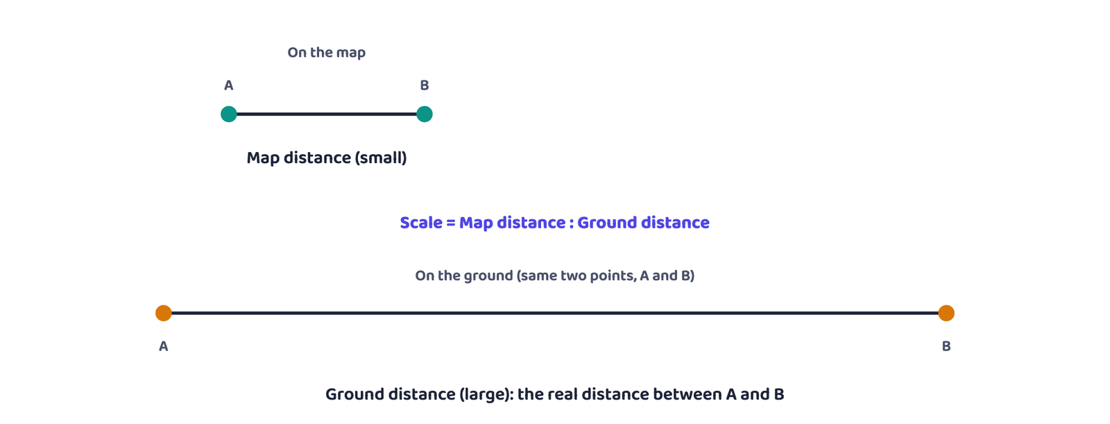
Chapter 21 already introduced scale as essential to every map. This chapter answers what follows from that: why scale matters, what it means, the different ways of showing it, and how useful it is for measuring distance and area.
2Systems of Measurement
Before looking at the methods of showing scale, you need the two systems of measurement that a scale can be expressed in. India uses the Metric System today, and used the English System before 1957.
| Metric System of Measurement | English System of Measurement |
|---|---|
| 1 km = 1,000 metres | 1 mile = 8 furlongs |
| 1 metre = 100 centimetres | 1 furlong = 220 yards |
| 1 centimetre = 10 millimetres | 1 yard = 3 feet |
| 1 foot = 12 inches |
The Metric System is used in India and in most countries of the world today. The English System is prevalent in both the United States and the United Kingdom; India also used it to measure and show linear distances before 1957.
3Three Methods of Expressing Scale
The relationship between map and ground can be shown in at least three ways. Each has its own advantage, and its own limitation.
Statement of Scale is a method of showing a map’s scale as a written sentence, for example “1 cm represents 10 km” or “1 inch represents 10 miles”. It is the simplest of the three methods.
Its two limitations are both real exam points: a reader who is not familiar with the system of measurement used in the statement cannot understand it, and if the map itself is enlarged or reduced, the statement becomes wrong and a fresh scale has to be worked out.
Graphical Scale (also called a Bar Scale) shows map distance and the corresponding ground distance using a line bar marked with primary and secondary divisions, so the reader measures distances directly off the bar. Unlike a Statement of Scale, it stays valid even when the map is enlarged or reduced, because the bar is redrawn along with the map.
Representative Fraction (R.F.) shows the relationship between map distance and ground distance as a fraction of units, with no unit named, for example 1 : 24,000. Since no specific unit is stated, R.F. is the most versatile, universally usable method.
| Method | Advantage | Limitation |
|---|---|---|
| Statement of Scale | Simplest to write and read | Only understood by someone familiar with that system of units; becomes invalid if the map is resized |
| Graphical / Bar Scale | Stays valid even when the map is enlarged or reduced | Still restricted to readers who understand the unit marked on the bar |
| Representative Fraction | No named unit, so any reader converts it into the system they prefer: it is universal | Gives no direct sense of the real-world distance until it is converted into a statement |
Q. Show that R.F. 1 : 36,000 can be read correctly by someone using the Metric System and by someone using the English System.
Metric reading: Take 1 unit as 1 cm. Then 36,000 units = 36,000 cm. Divide by 100 (cm in a metre): 36,000 ÷ 100 = 360 m. Statement: “1 cm represents 360 m”.
English reading: Take 1 unit as 1 inch. Then 36,000 units = 36,000 inches. Divide by 36 (inches in a yard): 36,000 ÷ 36 = 1,000 yards. Statement: “1 inch represents 1,000 yards”.
Both statements come from the exact same R.F. Neither system was named in “1 : 36,000” itself, which is exactly what lets both readers use it correctly. That is what “universal” means here.
“Which method of scale is universal?” is a very common one-mark MCQ. The answer is always Representative Fraction, because it is the only one of the three that names no unit.
4Conversion of Scale
Once you know the advantages and limitations of each method, converting a Statement of Scale into an R.F., and an R.F. back into a Statement of Scale, is just careful unit conversion.
4.1 Statement of Scale into R.F.
Given
Statement of Scale: 1 inch represents 4 miles
Find
The Representative Fraction
Step 1: Convert miles to inches. 1 mile = 63,360 inches, so 4 miles = 4 × 63,360 = 253,440 inches.
Step 2: The statement now reads “1 inch represents 253,440 inches”.
Step 3: Replace “inches” with the neutral word “units” on both sides: “1 unit represents 253,440 units”.
Answer: R.F. = 1 : 253,440
4.2 R.F. into Statement of Scale
Given
R.F. = 1 : 253,440
Find
Statement of Scale in the Metric System
Step 1: R.F. 1 : 253,440 means 1 unit on the map represents 253,440 of the same units on the ground.
Step 2: Read the unit as centimetres: 1 cm represents 253,440 cm.
Step 3: Convert cm to km by dividing by 100,000 (cm in a km): 253,440 ÷ 100,000 = 2.5344 km.
Step 4: Round to two decimal places.
Answer: 1 cm represents 2.53 km
Students forget Step 3 of the reverse conversion and leave the answer as “1 cm represents 253,440 cm”, which is technically true but is not a usable Statement of Scale. Always convert the ground-side unit up to a sensible unit (km, miles) before calling it your final answer.
5Construction of the Graphical Scale
A bar scale is built for a stated R.F. or Statement of Scale by first choosing the bar’s length, then working out what round real-world distance that length represents.
There is no fixed formula for the bar’s length: by convention, a bar meant to be read in the Metric System is drawn about 15 cm long, and one meant to be read in the English System is drawn about 6 inches long. Both are chosen simply for comfortable reading.
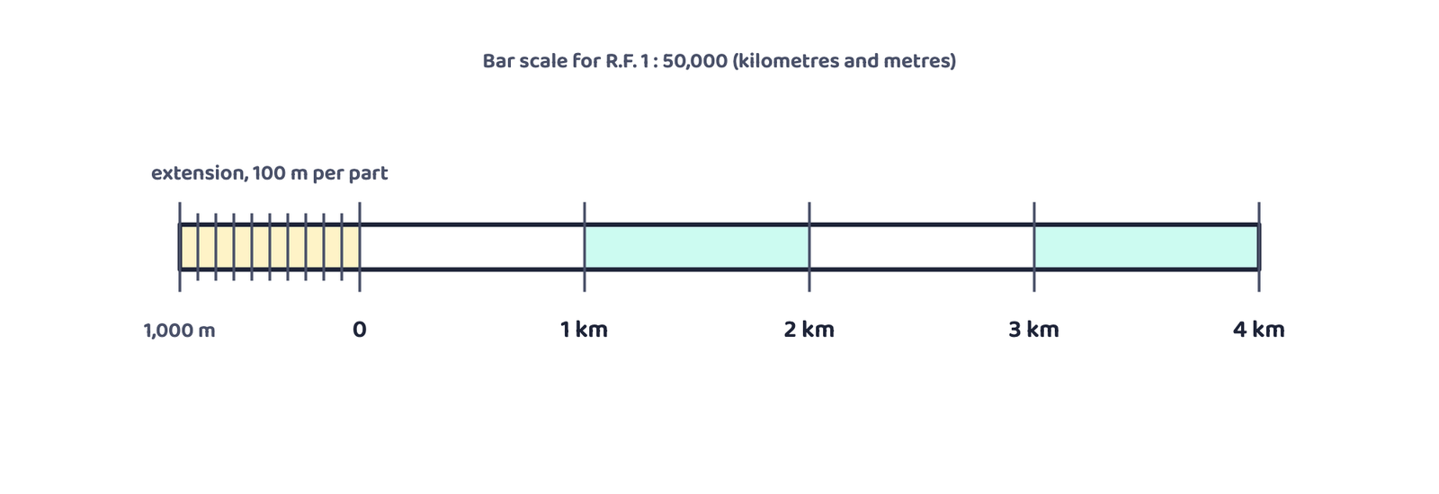
5.1 Constructing a scale in kilometres and metres
Given
A map drawn at R.F. 1 : 50,000
Find
A graphical scale reading kilometres and metres
Step 1: R.F. 1 : 50,000 means 1 cm represents 50,000 cm on the ground.
Step 2: Using the 15 cm convention: 15 cm represents 50,000 × 15 ÷ 100,000 = 7.5 km.
Step 3: 7.5 is not a round number, so round it to 5 km.
Step 4: Recompute the bar’s length for exactly 5 km: 15 × 5 ÷ 7.5 = 10 cm.
Step 5: Draw a 10 cm line. Divide it into 5 equal main parts. Mark the 4 right-hand parts 1, 2, 3, 4 km from the zero mark. Divide the one remaining left-hand part into 10 equal sub-parts and mark them in steps of 100 m (or into 2, 4 or 5 parts of 500, 250 or 200 m each).
5.2 Constructing a scale in miles and furlongs
Given
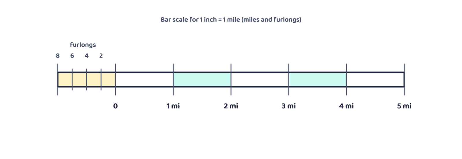
Statement of Scale: 1 inch represents 1 mile
Find
A graphical scale reading miles and furlongs
Step 1: Using the 6-inch convention: 6 inches represents 6 miles.
Step 2: Draw a 6-inch line and divide it into 6 equal parts. Mark the 5 right-hand parts 1, 2, 3, 4, 5 miles from the zero mark.
Step 3: Divide the one remaining left-hand part into 4 equal sub-parts and mark them in steps of 2 furlongs each, since 1 mile = 8 furlongs and 8 ÷ 4 = 2.
The English NCERT PDF’s text extraction for this last step reads “mark each division by a value of 2 miles each”. That cannot be right: splitting one mile into 4 sub-parts to read miles again makes no sense, and the whole point of this left-hand extension is to read distances smaller than a mile. The Hindi edition of the same passage is unambiguous: it gives each part a value of 2 furlongs, which also matches the arithmetic exactly (1 mile ÷ 4 = 2 furlongs). These notes use 2 furlongs.
5.3 An awkward length: dividing a line into equal parts geometrically
Given
R.F. = 1 : 50,000
Find
A graphical scale reading miles and furlongs
Step 1: 1 inch represents 50,000 inches on the ground.
Step 2: Using the 6-inch convention: 6 inches represents 50,000 × 6 ÷ 63,360 = 4.73 miles (not round).
Step 3: Round to 5 miles. Recompute the bar’s length for exactly 5 miles: 6 × 5 ÷ 4.73 = 6.34 inches, an awkward length that cannot easily be split into 5 equal parts by eye.
Draw the awkward line. From one end, draw an auxiliary ray at any convenient angle. Using a ruler, mark off as many equal steps on that ray as the number of equal parts you need (the step length does not have to match the original line at all). Join the last of these steps to the far end of the original line. Then, through each of the remaining marked steps, draw a line parallel to that joining line: each one crosses the original line at one of its equal divisions.
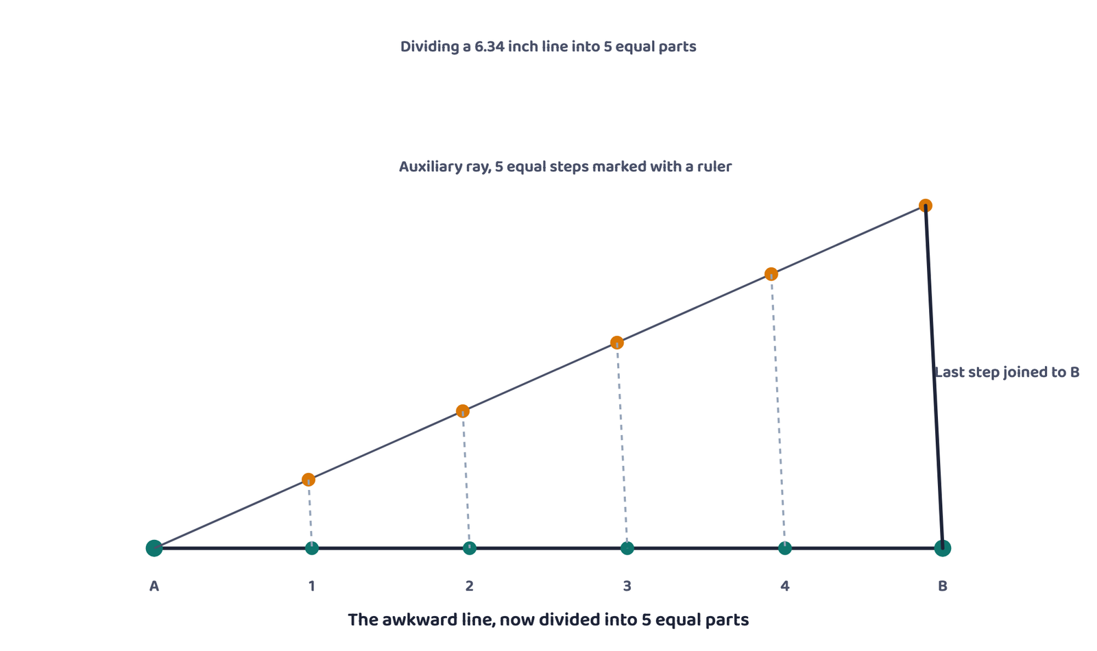
You will not usually be asked to draw Figure 4’s construction step by step in a written exam, but you may be asked to name the technique or explain why it is needed. Say it in one line: because 6.34 inches cannot be divided into 5 equal parts using an ordinary ruler alone.
- Scale = ratio of map distance to ground distance between the same two points; no scale means it is only a sketch
- Metric: 1 km = 1,000 m = 100,000 cm. English: 1 mile = 8 furlongs = 63,360 inches
- Three methods: Statement of Scale (simplest, breaks on resizing), Graphical/Bar Scale (survives resizing), Representative Fraction (universal, no unit named)
- R.F. 1 : 36,000 reads as both “1 cm = 360 m” and “1 inch = 1,000 yards”: same fraction, two valid readings
- Statement into R.F.: convert the ground unit into the map’s own unit, then replace the unit name with “units”
- R.F. into Statement: read both sides in the same unit, then convert the ground side up into km or miles
- Bar scale convention: about 15 cm for a metric reading, about 6 inches for an English reading
- When the round-number length comes out awkward (like 6.34 inches), an auxiliary ray with equal steps, joined and made parallel, divides it exactly
- 1 markWhich one of the following methods of scale is a universal method?
(a) Statement of Scale(b) Graphical Scale(c) Representative Fraction(d) None of the above - 1 markMap distance in a scale is also known as:
(a) Denominator(b) Statement of Scale(c) Representative Fraction(d) Numerator - 1 markIn a scale of 1 : 50,000, the Denominator represents:
(a) Map distance(b) Ground distance(c) Both the distances(d) Neither distance - 1 markFurlongs and yards belong to which system of measurement?
(a) Metric System(b) SI System(c) Decimal System(d) English System - 1 markA Statement of Scale becomes invalid the moment a map is:
(a) Enlarged or reduced(b) Coloured(c) Folded(d) Photocopied at the same size - 1 markR.F. 1 : 24,000 means 1 unit on the map represents how many of the same units on the ground?
(a) 24,000(b) 2,400(c) 240(d) 1 - 1 markBy convention, a graphical scale meant to be read in miles is usually drawn about:
(a) 15 cm long(b) 1 metre long(c) 6 inches long(d) 1 foot long - 1 markIndia used the English System of Measurement for linear distances up to the year:
(a) 1947(b) 1957(c) 1950(d) 1972
Reason (R): A Representative Fraction states the ratio using bare numbers with no named unit, so it can be converted into any system of measurement.
Reason (R): Enlarging or reducing a map changes the relationship between map distance and ground distance, so a new scale has to be worked out.
Reason (R): A Statement of Scale remains a correct description of the map even after the map has been enlarged or reduced.
- 1 markName the two systems of measurement used to express scale.
- 2 marksGive one example each of a Statement of Scale in the Metric System and in the English System.
- 1 markWhat is written in place of a named unit, such as cm or mile, in a Representative Fraction?
- 2 marksWhat is the biggest advantage of the Graphical/Bar Scale over the Statement of Scale?
- 1 markWhat is the Numerator in the fraction 1 : 40,000?
- 1 markName the three methods of expressing a map’s scale.
- 3 marksDistinguish between Statement of Scale and Graphical Scale, stating one advantage and one limitation of each.
- 3 marksWhy does a Statement of Scale become invalid when a map is enlarged or reduced, while a Graphical Scale stays valid?
- 3 marksUsing the worked example of R.F. 1 : 36,000, show why the Representative Fraction is called a universal method.
- 2 marksWhat are Numerator and Denominator in the context of map scale? Illustrate using the fraction 1 : 50,000.
- 2 marksWhat convention is followed for the length of a graphical scale drawn to be read in the Metric System, and in the English System?
- 2 marksWhy is the Numerator of a Representative Fraction always written as 1?
- 5 marksDescribe the three methods of expressing the scale of a map, with one advantage and one limitation of each.
- 5 marksExplain, with a suitable numerical example, how a Statement of Scale is converted into a Representative Fraction.
- 5 marksExplain, with a suitable numerical example, how a Representative Fraction is converted into a Statement of Scale.
- 5 marksDescribe, step by step, how a graphical scale is constructed for a map drawn at a given Representative Fraction, using a worked example.
- 2 marksConvert the Statement of Scale into Representative Fraction: 5 cm represents 10 km.
- 2 marksConvert the Statement of Scale into Representative Fraction: 2 inches represents 4 miles.
- 2 marksConvert the Statement of Scale into Representative Fraction: 1 inch represents 1 yard.
- 2 marksConvert the Statement of Scale into Representative Fraction: 1 cm represents 100 metres.
- 2 marksConvert the Representative Fraction 1 : 100,000 into a Statement of Scale in kilometres.
- 2 marksConvert the Representative Fraction 1 : 31,680 into a Statement of Scale in furlongs.
- 2 marksConvert the Representative Fraction 1 : 126,720 into a Statement of Scale in miles.
- 2 marksConvert the Representative Fraction 1 : 50,000 into a Statement of Scale in metres.
- 2 marksConvert the Statement of Scale “1 cm represents 5 km” into a Representative Fraction.
- 2 marksConvert the Representative Fraction 1 : 250,000 into a Statement of Scale in kilometres.
- 2 marksConvert the Representative Fraction 1 : 63,360 into a Statement of Scale in miles.
- 3 marksA map is drawn at R.F. 1 : 20,000. Using the 15 cm convention, find how many kilometres the bar represents, and state whether it needs to be re-drawn at a different length to show a round number.