Communication
gaugeKonkan RailwayNational WaterwayUDAN
GAILHVJ pipelineINSATIRSDoordarshan
1Transport and Communication: Meaning and Modes
Everything we use daily, from toothpaste to food grains, is produced somewhere else and has to reach us. Transport is what moves these goods from the place of production to the market where consumers buy them. We also exchange ideas, views and messages every day; moving these is communication. Both depend on the same basic need: moving something (goods, people or ideas) from the place it is available to the place it is needed.
Transport is the physical means of moving people, goods and materials from one place to another. Communication is the exchange of ideas, views and messages between people, across distance.
Ropeways, cableways and pipelines were also devised for transporting specific goods under special circumstances, such as over hilly terrain or for liquids and gases.
2Land Transport: Roads
2.1 Growth of roads in India
Pathways and unmetalled roads have carried India’s transport since ancient times; metalled roads and railways came later, with economic and technological development. Modern road transport stayed limited before World War II: the Nagpur Plan (1943) could not be implemented because the princely states and British India failed to coordinate. After Independence, a twenty-year road plan (1961) improved road conditions, but roads still concentrate around urban centres, leaving rural and remote areas the least connected.
India has one of the second largest road networks in the world, with a total length of about 62.16 lakh km (Ministry of Road Transport and Highways, Annual Report 2020-21).
2.2 Classification of roads
For construction and maintenance, roads are classified as National Highways, State Highways, District Roads, Rural Roads, and Other Roads (Border Roads and International Highways).
| Road category | Length in 2020 (km) |
|---|---|
| National Highways | 1,36,440 |
| State Highways | 1,76,818 |
| Other Roads | 59,02,539 |
| Total | 62,15,797 |
Source: Ministry of Road Transport and Highways, Annual Report 2020-21 (Table 7.1)
Roads carry about 85% of passenger traffic and 70% of freight traffic every year, and are best suited to shorter-distance travel. This statistic is asked directly almost every year.
National Highways (NH)
National Highways are the main roads constructed and maintained by the Central Government. They handle inter-state transport and the movement of defence men and material to strategic areas, and connect state capitals, major cities, important ports and railway junctions.
NH length grew from 19,700 km in 1951 to 1,36,440 km in 2020. National Highways form only about 2% of India’s total road length, but carry 40% of all road traffic.
Sher Shah Suri built the Shahi (Royal) road from the Indus Valley to the Sonar Valley in Bengal to strengthen his empire. The British renamed it the Grand Trunk (GT) Road, connecting Calcutta and Peshawar. Today it runs from Amritsar to Kolkata.
The National Highways Authority of India (NHAI) was operationalised in 1995. It is an autonomous body under the Ministry of Surface Transport, responsible for developing, maintaining and operating National Highways, and is the apex body for improving their quality.
Golden Quadrilateral
A 5,846-km, 4/6-lane, high-density traffic corridor connecting India’s four biggest metro cities: Delhi-Mumbai-Chennai-Kolkata. It cuts the time, distance and cost of movement between these mega cities.
North-South Corridor
Connects Srinagar (Jammu and Kashmir) with Kanniyakumari (Tamil Nadu), including the Cochin-Salem Spur, over 4,076 km.
East-West Corridor
Connects Silchar (Assam) with the port town of Porbandar (Gujarat), over 3,640 km.
The Bharatmala Pariyojana plans about 26,000 km of Economic Corridors that, with the GQ and NS-EW Corridors, will carry most of India’s road freight, plus ring roads and bypasses to decongest city traffic.
State Highways, District Roads and Rural Roads
| Road type | Built and maintained by | Connects |
|---|---|---|
| State Highways | State governments | State capitals with district headquarters and other important towns; linked to National Highways |
| District Roads | District administration | District headquarters with other important nodes in the district |
| Rural Roads | Local/rural bodies | Vital links within rural areas |
About 80% of India’s total road length is rural roads. Their density varies regionally because it is influenced by the nature of the terrain.
Other Roads: Border Roads and International Highways
The Border Roads Organisation (BRO) was established in May 1960 to accelerate economic development and strengthen defence preparedness through rapid, coordinated road-building along India’s northern and north-eastern boundary. It is a premier multifaceted construction agency: it built the road joining Chandigarh with Manali (Himachal Pradesh) and Leh (Ladakh), running at an average altitude of 4,270 metres above mean sea level, and it also undertakes snow clearance in high-altitude areas.
The world’s longest highway tunnel, the Atal Tunnel (9.02 km), was built by the BRO in the Pir Panjal range of the Himalayas at an altitude of 3,000 metres. It connects Manali to the Lahaul-Spiti valley throughout the year. Earlier, heavy snowfall cut the valley off for about 6 months every year.
International Highways promote harmonious relations with neighbouring countries by providing effective links with India, such as the Delhi-Lahore bus route via the Wagah Border and the Aman Setu between Baramula and Muzaffarabad.
3Land Transport: Railways
The Indian Railways network is one of the longest in the world. It moves both freight and passengers, and contributes directly to economic growth. Mahatma Gandhi said the railways “brought people of diverse cultures together to contribute to India’s freedom struggle.”
Indian Railways is the country’s largest government undertaking. Because its size is so large, it is divided into 17 zones to reduce the pressure of centralised management.
| Railway zone | Headquarters |
|---|---|
| Central | Mumbai CST |
| Eastern | Kolkata |
| East Central | Hajipur |
| East Coast | Bhubaneswar |
| Northern | New Delhi |
| North Central | Prayagraj |
| North Eastern | Gorakhpur |
| North East Frontier | Maligaon (Guwahati) |
| North Western | Jaipur |
| Southern | Chennai |
| South Central | Secunderabad |
| South Eastern | Kolkata |
| South East Central | Bilaspur |
| South Western | Hubli |
| Western | Mumbai (Church Gate) |
| West Central | Jabalpur |
| Metro Railway | Kolkata |
Steam engines have been replaced by diesel and electric engines, raising both speed and haulage capacity, and improving the environment around stations. Metro rail has revolutionised urban transport in India; replacing diesel buses with CNG vehicles, alongside metro, is a step towards controlling urban air pollution.
3.1 The three gauges
The gauge of a railway is the distance between the two rails of the track. Indian Railways has three gauges: broad, metre and narrow.
Lengths as of 2019-20. Narrow gauge is generally confined to hilly areas. Indian Railways has an extensive programme to convert metre and narrow gauge lines to broad gauge.
A 760-km rail route connecting Roha (Maharashtra) to Mangalore (Karnataka), an engineering marvel crossing 146 rivers on nearly 2,000 bridges and 91 tunnels, including Asia’s largest tunnel (~6.5 km). Maharashtra, Goa and Karnataka are partners in this undertaking.
Towns near raw-material and plantation areas, hill stations and cantonments were well connected by rail from the British colonial era, mainly to exploit resources. After Independence, railway routes were extended to other areas too: the most significant was the Konkan Railway along the western coast, directly linking Mumbai and Mangaluru. Even so, the railway network remains relatively less dense in the hill states, north-eastern states, central India and Rajasthan.
4Water Transport
Water transport is the cheapest mode of transport, most suitable for carrying heavy and bulky material, and it is fuel-efficient and eco-friendly. It is of two types: inland waterways and oceanic routes.
4.1 Inland waterways
Inland waterways were the chief mode of transport before railways arrived, but then faced tough competition from road and rail. Diverting river water for irrigation has also made large stretches non-navigable. India has 14,500 km of navigable waterways today, contributing about 1% of the country’s transportation, and comprising rivers, canals, backwaters and creeks.
The Inland Waterways Authority was set up in 1986 for the development, maintenance and regulation of national waterways. Under the National Waterways Act, 2016, 111 inland waterways (including 5 declared earlier) were declared National Waterways.
A National Waterway (NW) is a stretch of a river, canal or backwater declared by the Government of India as fit for the development and regulation of inland water transport, under the National Waterways Act, 2016.
| Waterway | Stretch | Specification |
|---|---|---|
| NW 1 | Prayagraj-Haldia (1,620 km) | Navigable by mechanised boats up to Patna, ordinary boats up to Haridwar. Three parts: Haldia-Farakka (560 km), Farakka-Patna (460 km), Patna-Prayagraj (600 km) |
| NW 2 | Sadiya-Dhubri (891 km) | Brahmaputra navigable by steamers up to Dibrugarh (1,384 km); shared by India and Bangladesh |
| NW 3 | Kottapuram-Kollam (205 km) | 168 km West Coast Canal, plus Champakara Canal (14 km) and Udyogmandal Canal (23 km) |
| NW 4 | Godavari and Krishna rivers, Puducherry stretch (1,078 km) | Along with Kakinada canals |
| NW 5 | River Brahmani stretches (588 km) | With the Matai river, Mahanadi-Brahmani delta channels, and East Coast canals |
Source: Annual Report, Ministry of Ports, Shipping & Waterways, 2022-23 (Table 7.3). The Inland Waterways Authority has identified 10 further inland waterways that could be upgraded.
Kerala’s backwaters (Kayal) have special significance for inland waterways: besides cheap transport, they attract large numbers of tourists. The famous Nehru Trophy Boat Race (Vallamkali) is held on the backwaters.
4.2 Oceanic routes
India has a vast coastline of about 7,517 km, including islands, served by 12 major and 200 minor ports. Oceanic routes carry about 95% of India’s foreign trade by volume and 70% by value. Besides international trade, they are also used to transport goods between the islands and the rest of the country.
5Air Transport
Air transport is the fastest means of movement, reducing distance by minimising travel time. It is essential for a vast country like India, where distances are large and terrain and climate are diverse.
Air transport in India began in 1911, when airmail operations started over a short distance of 10 km between Prayagraj and Naini. Its real development came after Independence. The Airport Authority of India (AAI) is responsible for providing safe, efficient air traffic and aeronautical communication services in Indian airspace.
UDAN (Ude Desh ka Aam Nagrik), run as the Regional Connectivity Scheme (RCS) by the Ministry of Civil Aviation, is a first-of-its-kind scheme globally that jump-starts the regional aviation market by encouraging airlines to fly regional and remote routes through enabling policies and incentives, making air travel affordable for the common citizen.
Pawan Hans is a helicopter service widely used by tourists in the hilly, north-eastern parts of the country; it also serves the petroleum sector and tourism more generally.
6Oil and Gas Pipelines
Pipelines are the most convenient and efficient way to move liquids and gases over long distances. Even solids can be transported by pipeline once converted to slurry.
This HVJ artery gave impetus to the Indian gas market. Overall, India’s gas pipeline infrastructure has expanded more than ten times, from 1,700 km to 18,500 km, and is expected to soon reach over 34,000 km as a Gas Grid linking all gas sources and consuming markets across the country, including the North Eastern states.
7Communication Networks
Humans have used many methods of communication over time: beating drums or hollow tree trunks, smoke or fire signals, and fast runners, horses, camels, dogs and birds to carry messages. Early on, the means of communication were often also the means of transportation. The invention of the post office, telegraph, printing press, telephone and satellite, driven by advances in science and technology, made communication much faster and easier.
Based on scale and quality, modes of communication fall into two categories: the Personal Communication System, one-to-one contact such as the internet and e-mail, and the Mass Communication System, which reaches large audiences at once through radio, television and satellites.
7.1 Personal communication: the internet
Among personal communication systems, the internet is the most effective and advanced, widely used in urban areas. It gives users direct contact through e-mail, access to the world’s knowledge, and is used for e-commerce and money transactions: a huge central warehouse of data, giving efficient, low-cost access to information.
7.2 Mass communication: Radio
All India Radio broadcasts programmes on information, education and entertainment, along with special news bulletins on occasions like sessions of Parliament and the state legislatures.
7.3 Mass communication: Television
7.4 Satellite communication
Satellites are a mode of communication in themselves, and they also regulate the use of other means of communication. A continuous, synoptic (whole-area) view from satellites makes satellite communication very important for economic and strategic reasons, and is used for weather forecasting, monitoring natural calamities, and surveillance of border areas.
Based on configuration and purpose, India’s satellite systems fall into two groups: the Indian National Satellite System (INSAT), a multipurpose satellite system for telecommunication, meteorological observation and various other data and programmes; and the Indian Remote Sensing Satellite System (IRS), which collects data in several spectral bands and transmits it to ground stations for various uses.
The National Remote Sensing Centre (NRSC), at Hyderabad, provides facilities for acquiring and processing this data, which is very useful in managing natural resources.
- Transport moves goods, people and materials; communication moves ideas, views and messages. Land, water and air are the three broad modes.
- Roads: total ~62.16 lakh km (2020). NH = 2% of length but 40% of traffic; grew from 19,700 km (1951) to 1,36,440 km (2020). NHAI (1995) develops and maintains NH.
- Golden Quadrilateral (5,846 km, Delhi-Mumbai-Chennai-Kolkata), North-South Corridor (4,076 km), East-West Corridor (3,640 km); Bharatmala Pariyojana adds ~26,000 km of Economic Corridors.
- BRO (est. May 1960) builds/maintains strategic border roads, incl. the Atal Tunnel (9.02 km, world’s longest highway tunnel).
- Rural roads = ~80% of total road length. State/District/Rural roads have their own tier below National Highways.
- Railways: started 1853 (Bombay-Thane, 34 km); 67,956 km network (2019-20); 17 zones; three gauges (broad 1.676 m/63,950 km is dominant); Konkan Railway (1998, 760 km, Roha-Mangalore) is the biggest post-Independence rail achievement.
- Water transport is the cheapest and most eco-friendly mode: inland waterways (14,500 km navigable; 111 National Waterways under the 2016 Act) and oceanic routes (7,517-km coastline; 95% of foreign trade by volume moves by sea).
- Air transport is the fastest mode; began 1911 (Prayagraj-Naini airmail). AAI runs air traffic control; UDAN/RCS makes regional flying affordable; Pawan Hans runs helicopter services.
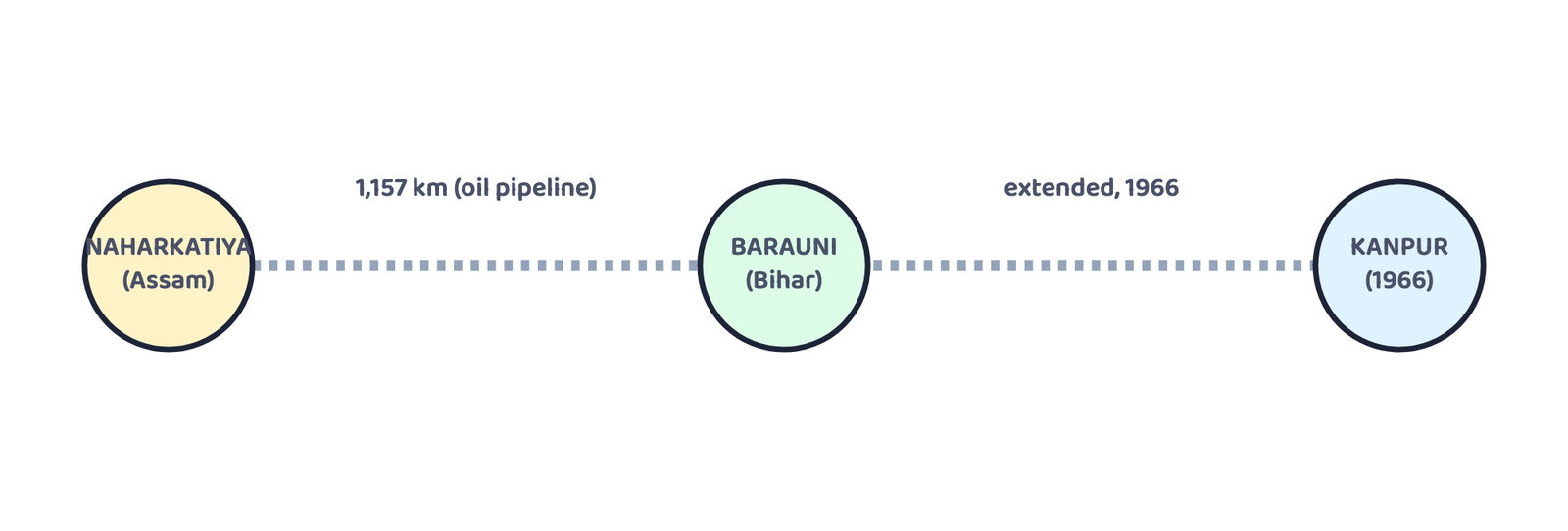
- Pipelines move liquids, gases and slurried solids. OIL (1959) built Asia’s first cross-country pipeline (Naharkatiya-Barauni, 1,157 km). GAIL (1984) built the HVJ pipeline; gas infrastructure has grown from 1,700 km to 18,500 km, targeting 34,000 km as a Gas Grid.
- Communication is personal (internet) or mass (radio, TV, satellite). Radio: 1923 to Akashwani (1957). TV: 1959 to Doordarshan (1976) and CNP after INSAT-1A. Satellites: INSAT (1983, multipurpose) and IRS (IRS-1A, March 1988, via India’s own PSLV); NRSC (Hyderabad) processes remote-sensing data.
- 1 markDefine transport and communication.
- 1 markInto how many zones is the Indian Railways system divided?
- 1 markIn which year did radio broadcasting start in India, and by whom?
- 1 markName the two types of water transport.
- 1 markWhat does UDAN stand for?
- 1 markName the two Indian satellite systems, based on configuration and purpose.
- 1 markWhich organisation built the Atal Tunnel?
- 1 markIn which year was the Border Roads Organisation established?
- 3 marksWhich activity does transportation convey? Name three major modes of transportation.
- 3 marksDiscuss the advantages and disadvantages of pipeline transportation.
- 2 marksWhat do you mean by ‘communication’? Name its two broad categories.
- 2 marksDistinguish between broad gauge and narrow gauge railway tracks.
- 3 marksWhat is the National Highways Authority of India, and what is it responsible for?
- 2 marksDistinguish between National Highways and State Highways.
- 3 marksWhy is water transport considered the cheapest mode of transport in India?
- 2 marksWhat is the Golden Quadrilateral? Which four cities does it connect?
- 3 marksExplain the role of the Border Roads Organisation in India.
- 2 marksWhy did modern road transport remain limited in India before World War II?
- 3 marksWhat is UDAN? What is its central idea?
- 2 marksName any two National Waterways of India, with the stretch each one covers.
- 5 marksWhich are the chief means of transportation in India? Discuss the factors affecting their development.
- 5 marksGive a detailed account of the development of railways in India and highlight their importance.
- 5 marksDescribe the role of roads in the economic development of India.
- 5 marksDescribe the growth and development of India’s road network, with reference to the Golden Quadrilateral and the North-South/East-West Corridors.
- 5 marksExplain the development of oil and gas pipelines in India, with examples.
- 5 marksDiscuss the growth of mass communication in India through radio, television and satellites.
- 1 markInto how many zones has the Indian Railways system been divided?
(a) 9(b) 12(c) 17(d) 14 - 1 markOn which river, and between which two places, does National Waterway No. 1 lie?
(a) The Brahmaputra, Sadiya-Dhubri(b) The Ganga, Haldia-Prayagraj
(c) West Coast Canal, Kottapuram-Kollam(d) Godavari-Kakinada, Puducherry - 1 markIn which year was the first radio programme broadcast in India?
(a) 1911(b) 1936(c) 1927(d) 1923 - 1 markThe distance between rails in broad gauge is:
(a) 1 metre(b) 1.676 metres(c) 0.762 metres(d) 0.610 metres - 1 markThe Golden Quadrilateral connects:
(a) Delhi-Mumbai-Chennai-Kolkata(b) Srinagar-Kanniyakumari
(c) Silchar-Porbandar(d) Amritsar-Kolkata - 1 markThe Konkan Railway connects:
(a) Roha to Mangalore(b) Bombay to Thane
(c) Delhi to Kolkata(d) Chandigarh to Leh - 1 markDoordarshan got a separate identity from All India Radio in:
(a) 1959(b) 1972(c) 1976(d) 1983 - 1 markAsia’s first cross-country pipeline, built by Oil India Limited, ran between:
(a) Naharkatiya and Barauni(b) Hazira and Jagdishpur
(c) Mumbai High and Bassein(d) Roha and Mangalore
Reason (R): National Highways form only about 2% of India’s total road length.
Reason (R): Water transport is fuel-efficient and is best suited to carrying heavy, bulky material.
Reason (R): Dividing such a large network reduces the pressure of centralised railway management.
Reason (R): UDAN encourages airlines to operate flights on regional and remote routes by offering enabling policies and incentives.