- Why continents fit together like jigsaw pieces, and what Alfred Wegener said about it
- The five kinds of evidence scientists used to prove continents once moved
- What the ocean floor actually looks like, and why it is not a flat plain
- How Harry Hess explained new crust being born and old crust being destroyed
- The 7 major plates of the earth, and the three ways their edges behave
- How India travelled from near Australia to crash into Asia and build the Himalayas
sea floor spreadinglithosphereasthenospheretectonic plate
subduction zonedivergent boundaryconvergent boundarytransform boundary
1Continental Drift
Look at a world map and cover the Atlantic Ocean with your thumb. The eastern coast of South
America and the western coast of Africa almost fit together, like two pieces of a jigsaw puzzle
that have been pulled apart. Many scientists noticed this a long time ago and wondered whether
these continents were once joined.
Continental drift is the idea that continents were once joined together as a single
landmass, and have since drifted apart to their present positions, and are still moving today.
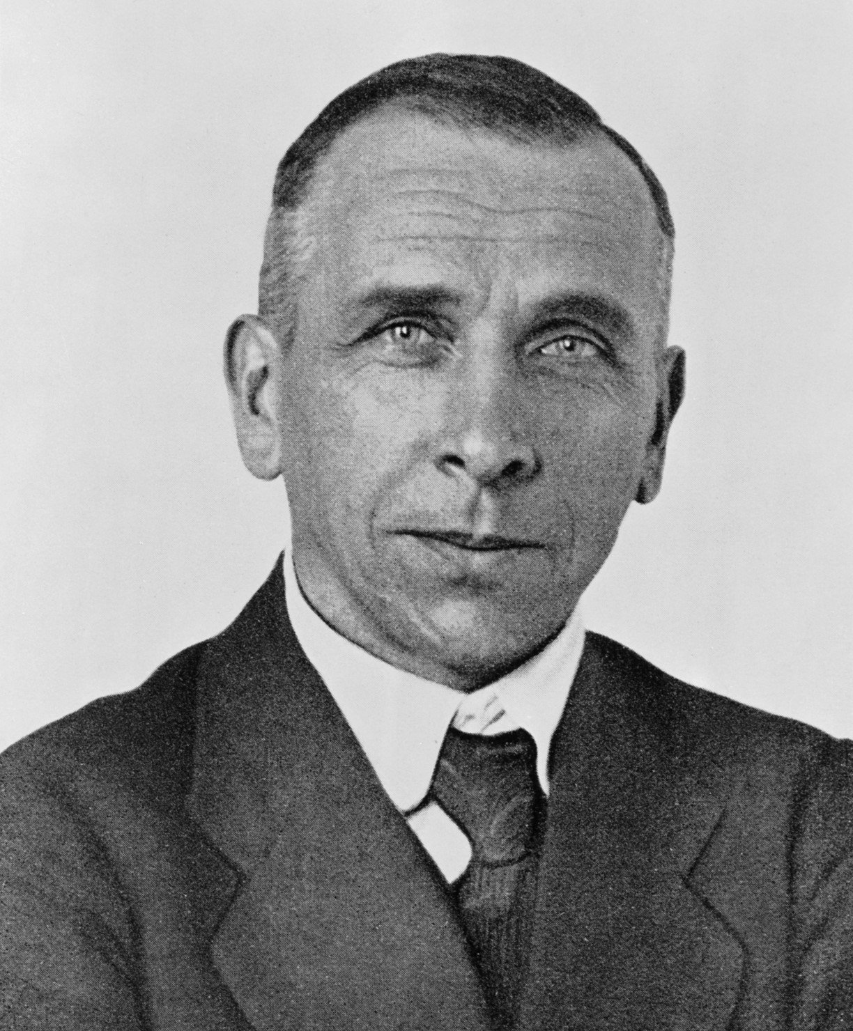
meteorologist who proposed the continental drift theory in 1912. Photo: Bildindex der Kunst
und Architektur / Wikimedia Commons / Public Domain.
According to Wegener, all the continents were once joined into a single giant landmass, with
one huge ocean surrounding it.
Wegener named the supercontinent Pangaea (meaning “all earth”) and the single mega-ocean
around it Panthalassa (meaning “all water”).
Wegener said that about 200 million years ago, Pangaea began to break apart. This did
not happen in one piece all at once. It split step by step, like a cracked plate coming apart
slowly.
Wegener was not a geologist at all. He was trained as a meteorologist, someone who studies
weather. He got interested in continental drift almost by accident, while looking at a world
map and noticing how well the coastlines matched.
2Evidence in Support of Continental Drift
A good idea in science needs proof. Wegener and the scientists after him collected several
different kinds of evidence, from rocks, fossils and even gold, that all pointed to the same
answer: the continents really did move.
The Matching of Continents (Jig-Saw-Fit)
The shorelines of Africa and South America facing each other match almost perfectly. In
1964, a scientist named Bullard used a computer programme to test this fit, not at
today’s shoreline, but at the 1,000-fathom line (a depth line under the sea). The
match came out nearly perfect.
Rocks of Same Age Across the Oceans
Using radiometric dating (a method that tells a rock’s age from radioactive elements
inside it), scientists found that a belt of rocks 2,000 million years old on the
Brazil coast exactly matches rocks on the western African coast. The earliest sea deposits on
both coasts are of the Jurassic age, meaning the ocean between them did not exist
before that time.
Tillite
Tillite is sedimentary rock formed from the deposits left behind by glaciers. India’s
Gondwana rock system has matching tillite in six landmasses of the Southern Hemisphere:
India, Africa, Falkland Islands, Madagascar, Antarctica and Australia. Such widely
separated regions sharing the same glacial history makes sense only if they were once joined.
Placer Deposits
Rich gold placer deposits are found on the coast of Ghana, but the source rock that
such gold normally comes from is completely missing there. The matching gold-bearing veins are
found across the ocean in Brazil, meaning the Ghana deposits are gold washed down from
the Brazilian plateau, back when the two continents lay side by side.
Distribution of Fossils
Fossils of Lemurs (small tree-living mammals) are found in India, Madagascar and
Africa, three places now separated by ocean, leading some scientists to imagine a lost
connecting landmass called “Lemuria”. Fossils of Mesosaurus, a small reptile that
could only live in shallow, brackish water, are found in only two places on Earth: the
southern Cape province of South Africa, and the Iraver rock formations of Brazil, 4,800 km
apart today, with a full ocean in between. A small land reptile could never have swum that far.
“Give evidence in support of continental drift” is a standard 150-word question. Learn all
five pieces of evidence by their names: Jig-Saw-Fit, Rocks of Same Age, Tillite, Placer
Deposits, Distribution of Fossils. One line each is usually enough for full marks.
3Force for Drifting
If continents really moved, something had to be pushing or pulling them. Wegener suggested two
forces.
Polar-fleeing force
- Related to the rotation of the earth
- The earth is not a perfect sphere: it bulges slightly at the equator because of its rotation
- Wegener believed this bulge pushed continents towards the equator
Tidal force
- Caused by the gravitational pull of the moon and the sun
- This is the same pull that creates ocean tides
- Wegener believed tidal pull, acting over millions of years, could also move continents
Do not write that these two forces are the accepted reason for continental drift today. The
chapter itself says most scholars considered both forces totally inadequate, far too
weak to move something as massive as a continent. The real driving force (mantle convection) is
explained later in this chapter.
4Post-drift Studies
Most of the evidence Wegener collected came from land: fossils, rocks, tillite. After
World War II, a lot of new exploration happened on the ocean floor itself, and this gave
science a completely new set of clues.
The Convectional Current Theory, proposed by Arthur Holmes in the 1930s,
suggested that heat from radioactive elements inside the earth creates convection currents in
the mantle: currents strong enough to explain how continents could be pushed around.
Holmes’s idea was an early attempt to answer the “force” problem that had made scientists
reject Wegener’s continental drift theory in the first place. His own two forces (polar-fleeing
and tidal) were too weak, but a convecting mantle underneath the plates was not.
5Ocean Floor Configuration
Detailed mapping of the ocean floor after World War II revealed something surprising: the
sea bed is not a flat, featureless plain at all. It has mountain ranges, deep trenches and wide
plains, its own kind of landscape, just underwater. The ocean floor is divided into three main
parts, based on their depth and shape.
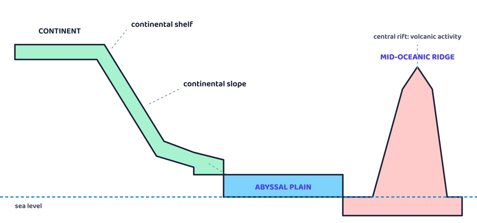
the shelf and slope near the continent, the wide abyssal plain, and the mid-oceanic ridge rising
in the middle of the ocean. This is a profile of depth, not a picture of any real country or coastline.
| Division | Where it lies | What it is |
|---|---|---|
| Continental margins | Transition between the continent and the deep sea | Includes the continental shelf, continental slope, continental rise, and the deep-oceanic trenches. The trenches matter most for this chapter’s story |
| Abyssal plains | Between the continental margins and the mid-oceanic ridges | Wide, flat plains where sediment washed off the continents finally settles |
| Mid-oceanic ridges | Roughly through the middle of the ocean basins | An interconnected chain of underwater mountains, the longest mountain system on earth, though it is completely submerged. It has a central rift valley (very active volcanically), a raised plateau, and flank zones along its length |
6Distribution of Earthquakes and Volcanoes
The textbook shows this as a world map, but the pattern itself can be learned perfectly well
as a list of belts, which is exactly what you would need to reproduce in an answer anyway.
A seismic and volcanic belt is a long, narrow zone along which earthquakes and volcanic
eruptions repeatedly occur, usually because it marks the edge of a moving plate.
| Belt | Where it runs | Character |
|---|---|---|
| Mid-oceanic belt | A line through the central Atlantic Ocean, parallel to the coastlines, extending into the Indian Ocean. It splits south of the Indian subcontinent into one branch towards East Africa and another meeting a line running from Myanmar to New Guinea |
Coincides exactly with the mid-oceanic ridges. Earthquakes here are shallow-focus (occur near the surface) |
| Alpine-Himalayan belt and rim of the Pacific | Follows the Alpine-Himalayan mountain system and circles the edge of the Pacific Ocean | Earthquakes here are deep-seated (occur far below the surface). The Pacific rim is also called the “Ring of Fire” because of its many active volcanoes |
If a question asks you to describe the world distribution of earthquakes and volcanoes,
write it exactly like the table above. Name the two belts, say where each one runs, and give
the one fact that makes each memorable: shallow focus at mid-oceanic ridges, deep focus and
the “Ring of Fire” along the Pacific rim.
7Concept of Sea Floor Spreading
By the time Wegener proposed continental drift, nobody had mapped the ocean floor properly.
Once that mapping was done, along with studying the magnetism trapped inside ocean-floor rocks,
five striking facts came to light.
| # | Fact discovered | What it means |
|---|---|---|
| i | Volcanic eruptions along the ridges | Eruptions are common all along the mid-oceanic ridges, bringing huge amounts of lava to the surface there |
| ii | Rocks get older away from the ridge | Rocks equal distances from the crest, on either side, share the same age, chemistry and magnetism. Rocks near the ridge are youngest with normal polarity; age rises steadily further out |
| iii | Oceanic crust is much younger than continents | Ocean-floor rocks are nowhere older than 200 million years, while some continental rocks are as old as 3,200 million years |
| iv | Ocean-floor sediment is unexpectedly thin | A floor as old as the continents should carry a much thicker sediment record, but nowhere is the sediment layer older than 200 million years |
| v | Deep trenches have deep-focus quakes | Deep-sea trenches have deep-seated earthquakes; mid-oceanic ridges have only shallow-focus ones, the opposite pattern from each other |
Sea floor spreading, proposed by Harry Hess in 1961, is the idea that constant
volcanic eruptions at the crest of mid-oceanic ridges keep splitting the oceanic crust, and new
lava wedges into the crack, pushing the ocean floor apart on either side, so the ocean keeps
growing wider.
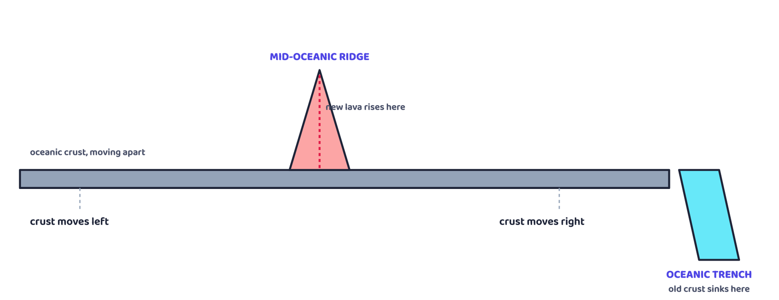
the ridge crest and pushed outward; the oldest crust is eventually consumed at a trench, a
process called subduction. A depth profile, not a picture of any coastline.
Because the oceanic crust near a ridge is always young, and because one ocean spreading does
not shrink another, Hess reasoned that old crust must be getting destroyed somewhere else, at the
deep-sea trenches, where the ocean floor sinks back down and is consumed. This is called
subduction.
8Plate Tectonics
Sea floor spreading explained how the ocean floor moves. In 1967, scientists
McKenzie and Parker, and independently Morgan, combined all the available ideas
into one bigger concept: Plate Tectonics.
A tectonic plate (also called a lithospheric plate) is a massive, irregularly-shaped
slab of solid rock made of both continental and oceanic lithosphere (the crust plus the
topmost, rigid part of the mantle). Plates move horizontally over the soft, plastic layer
beneath them, the asthenosphere.
A plate is called oceanic or continental depending on which type of lithosphere
covers more of it. The Pacific plate is mostly oceanic, while the Eurasian plate is mostly
continental. Young fold mountains, trenches and faults all mark the boundaries between plates.
| Major plate | Notes |
|---|---|
| I. Antarctica | Includes the surrounding oceanic plate around it |
| II. North American | Includes the western Atlantic floor; separated from the South American plate along the Caribbean islands |
| III. South American | Includes the western Atlantic floor; separated from the North American plate along the Caribbean islands |
| IV. Pacific | Almost entirely oceanic. No major continent sits on it |
| V. India-Australia-New Zealand | One combined plate carrying all three landmasses |
| VI. Africa | Includes the eastern Atlantic floor |
| VII. Eurasia | Includes the adjacent oceanic plate |
| Minor plate | Located between |
|---|---|
| Cocos | Central America and the Pacific plate |
| Nazca | South America and the Pacific plate |
| Arabian | Mostly the Saudi Arabian landmass |
| Philippine | The Asiatic and Pacific plates |
| Caroline | The Philippine and Indian plates, north of New Guinea |
It is not the continent that moves. The continent is only part of a plate, and it is the
whole plate that moves.
The single correction plate tectonics made to Wegener’s original idea
Do not write that Pangaea was one original landmass that simply cracked apart. Later discoveries
showed the opposite sequence too: continental masses riding on different plates were themselves
wandering the globe for a long time, and Pangaea was actually the result of several of them
converging together before it broke apart again. Scientists trace continents’ past
positions using palaeomagnetic data. For the Indian subcontinent, this was done using
rocks from the Nagpur area.
8.1 Types of plate boundaries
Wherever two plates meet, one of three things happens.
Divergent Boundaries
New crust is generated as two plates pull away from each other. The place where this
happens is called a spreading site. The best-known example is the Mid-Atlantic
Ridge, where the American plates separate from the Eurasian and African plates.
Convergent Boundaries
Crust is destroyed as one plate dives under another. The place where a plate sinks is
called a subduction zone. Convergence happens in three ways: (i) an oceanic plate meets
a continental plate, (ii) two oceanic plates meet, or (iii) two continental plates meet.
Transform Boundaries
Crust is neither made nor destroyed. The two plates simply slide past each other
horizontally. Transform faults are the planes along which this sliding happens, usually
running roughly perpendicular to the mid-oceanic ridges.
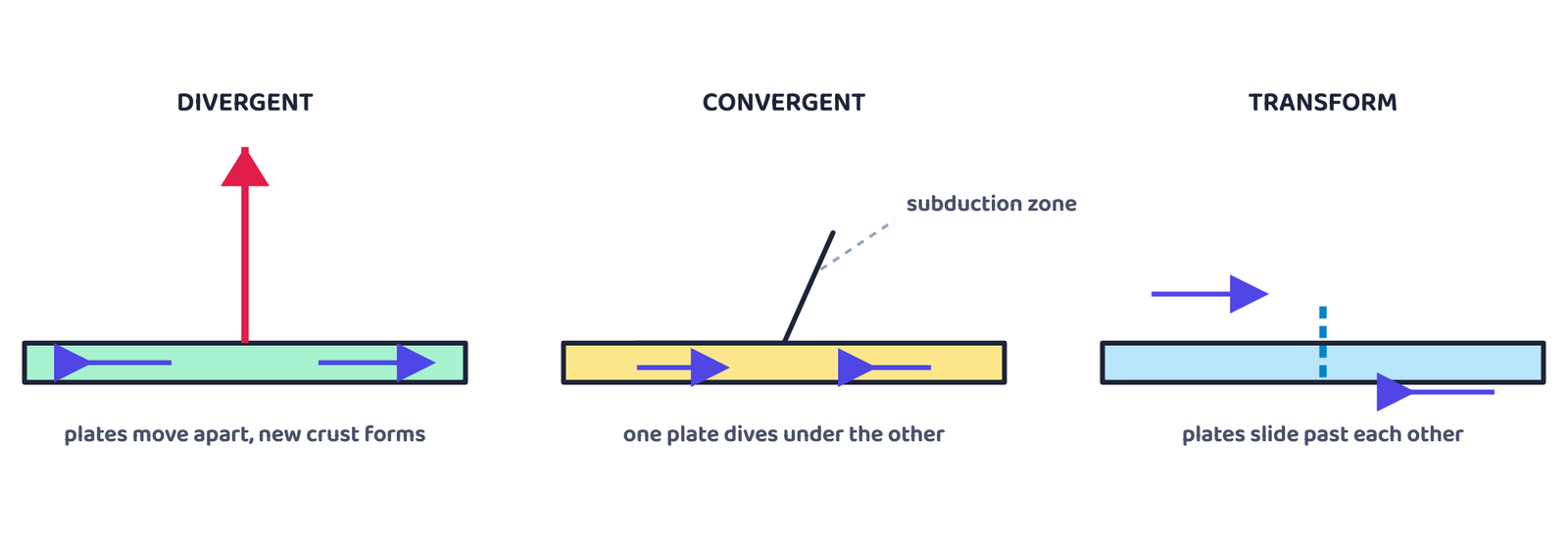
schematics. Arrows show plate movement only, drawn as abstract blocks rather than any real coastline.
8.2 Rates and force of plate movement
Scientists measure how fast plates move using strips of normal and reversed magnetic field
that lie parallel to the mid-oceanic ridges. The rates vary enormously.
A convection cell (or convective flow) is a circular movement of hot material: heated
rock rises towards the surface, spreads out, cools, and sinks back down, repeating endlessly.
This slow circulation in the mantle, driven by heat from radioactive decay and residual heat, is
believed to be the real driving force behind plate movement.
Arthur Holmes first suggested mantle convection in the 1930s, the same decade he proposed the
Convectional Current Theory in Section 4. His idea later directly influenced Harry Hess’s thinking
about sea floor spreading. One scientist’s idea, thirty years apart, quietly connects three
different sections of this chapter.
9Movement of the Indian Plate
The Indian plate is not just Peninsular India. It also includes the Australian continental
portion. Its four boundaries are all different types.
| Boundary | Description | Type |
|---|---|---|
| North | Subduction zone along the Himalayas | Continent-continent convergence |
| East | Through the Rakhine Yoma mountains of Myanmar to the island arc along the Java Trench; further east, a spreading site lies east of Australia | Convergent (west), Divergent (east) |
| West | Follows the Kirthar mountains of Pakistan, along the Makran coast, joining the Red Sea rift’s spreading site along the Chagos Archipelago | Divergent (spreading site) |
| South | Oceanic ridge boundary with the Antarctic plate, running roughly west to east, merging into a spreading site just south of New Zealand | Divergent boundary |
A common question asks for the position of the Indian landmass during Deccan Trap formation.
Answer in one line: “The subcontinent was still close to the equator, moving north towards Asia,
about 60 million years ago.” This is a direct 30-word answer from the timeline above.
- Can I name all five pieces of evidence for continental drift, without looking?
- Can I list the 7 major plates and at least 3 minor plates?
- Can I explain the difference between divergent, convergent and transform boundaries in one line each?
- Can I state the four boundary types of the Indian plate and one fact about each?
- Can I explain, in my own words, why “the plate moves, not the continent”?
- Wegener (1912): all continents were once joined as Pangaea, surrounded by Panthalassa
- Five evidences: Jig-Saw-Fit, Rocks of Same Age, Tillite, Placer Deposits, Distribution of Fossils
- Wegener’s forces (polar-fleeing, tidal) were rejected as too weak
- Ocean floor has 3 parts: continental margins, abyssal plains, mid-oceanic ridges
- Hess (1961): sea floor spreading. New crust at ridges, old crust destroyed at trenches
- Plate tectonics (1967, McKenzie-Parker-Morgan): 7 major plates plus several minor plates; the plate moves, not just the continent
- Three boundary types: divergent (pull apart), convergent (collide and subduct), transform (slide past)
- Indian plate: north = continent-continent convergence (Himalayas); east, west, south = mostly divergent or spreading
- India’s journey: island near Australia, crossed the Tethys Sea, collided with Asia about 40-50 million years ago, still pushing the Himalayas higher today
- 1 markWho was the first to consider the possibility of Europe, Africa and America being located side by side?
(a) Abraham Ortelius(b) Alfred Wegener
(c) Antonio Pellegrini(d) Edmond Hess - 1 markThe polar-fleeing force relates to:
(a) Revolution of the earth(b) Gravitation
(c) Rotation of the earth(d) Tides - 1 markWhich one of the following is NOT a minor plate?
(a) Nazca(b) Arabia
(c) Philippines(d) Antarctica - 1 markWhich fact was NOT considered while discussing sea floor spreading?
(a) Distribution of fossils in different continents(b) Stripes of normal and reverse magnetic field in ocean-floor rocks
(c) Volcanic activity along mid-oceanic ridges(d) Age of rocks from the ocean floor - 1 markWhat type of plate boundary runs along the Himalayan mountains?
(a) Ocean-continent convergence(b) Divergent boundary
(c) Transform boundary(d) Continent-continent convergence - 1 markThe Mid-Atlantic Ridge is the best-known example of a:
(a) Convergent boundary(b) Divergent boundary
(c) Transform boundary(d) Subduction zone - 1 markFossils of Mesosaurus are found in:
(a) India and Madagascar(b) Ghana and Brazil
(c) South Africa and Brazil(d) Africa and Antarctica - 1 markSea floor spreading was proposed by:
(a) Alfred Wegener(b) Arthur Holmes
(c) Harry Hess(d) Bullard - 1 markPanthalassa, the mega-ocean Wegener described, means:
(a) All rock(b) All water
(c) All ice(d) All earth - 1 markWho first drew a map showing Europe, Africa and America joined together as one piece?
(a) Antonio Pellegrini(b) Arthur Holmes
(c) Harry Hess(d) Alfred Wegener
Reason (R): New oceanic crust is constantly created at mid-oceanic ridges and destroyed at trenches, so it never gets very old.
Reason (R): Continents are part of tectonic plates, and it is the whole plate, not the continent alone, that moves.
- 3 marksWhat forces did Wegener suggest for the movement of the continents?
- 3 marksHow are convection currents in the mantle initiated and maintained?
- 3 marksWhat is the major difference between a transform boundary and a convergent or divergent boundary?
- 3 marksWhere was the Indian landmass located during the formation of the Deccan Traps?
- 5 marksWhat is the evidence in support of the continental drift theory?
- 5 marksExplain the basic difference between the drift theory and plate tectonics.
- 5 marksWhat were the major post-drift discoveries that revived scientists’ interest in the study of oceans and continents?
on the western African coast. They also found that the earliest marine deposits along both
coastlines are of the Jurassic age.
- 1 markWhat does the Jurassic age of the earliest marine deposits tell us about the ocean between Brazil and Africa?
- 2 marksName the piece of evidence for continental drift that this passage describes.