- How the hydrological cycle keeps the same water moving between ocean, air and land forever
- The four major divisions of the ocean floor, and how to tell them apart by gradient and depth
- The five minor relief features of the ocean floor, each with a real example
- The four factors that control how warm or cold a patch of ocean is
- How temperature changes with depth in three layers, and what a thermocline is
- How salinity is measured and why it varies from sea to sea, both sideways and with depth
1The Hydrological Cycle
Water is the only substance on earth found naturally as a solid, a liquid and a gas, and it never runs out anywhere on the planet. It just keeps moving, from the ocean to the air, from the air to the land, and back to the ocean again. The earth’s surface has an abundant supply of water, which is exactly why our planet is called the “Blue Planet.” No other body in the solar system has this.
The hydrological cycle is the continuous movement of water on, in, and above the earth, in its liquid, solid and gaseous forms. It describes the constant exchange of water between the oceans, the atmosphere, the land surface, the ground below the surface, and living things.
Water is a cyclic resource: it can be used and re-used, because the cycle has been running for billions of years and never adds or removes water from the planet as a whole. About 91% of all the water on earth is stored in the oceans. The rest is freshwater, held in glaciers and icecaps, groundwater, lakes, soil moisture, the atmosphere, streams, and inside living things.
| Where water is stored | How it moves |
|---|---|
| Water storage in oceans | Evaporation, evapotranspiration, sublimation |
| Water in the atmosphere | Condensation, precipitation |
| Water storage in ice and snow | Snowmelt runoff into streams |
| Surface runoff | Stream flow, freshwater storage, infiltration |
| Groundwater storage | Groundwater discharge, springs |
Nearly 59% of the water that falls on land goes straight back to the atmosphere through evaporation, mostly from the oceans but also from other places. The rest either runs off on the surface, soaks into the ground, or turns into glacier ice. The amount of renewable water on earth stays constant, but demand for it keeps rising sharply, which is why water shortages, both in place and over time, are increasing, made worse by river pollution.
A very common one-mark question lists four processes and asks which one is NOT part of the hydrological cycle. Check your answer against the cycle diagram above: evaporation, condensation, precipitation, evapotranspiration, sublimation and infiltration are all part of it. Hydration (a chemical reaction where a substance combines with water) is not.
2Relief of the Ocean Floor
Oceans sit inside the great depressions of the earth’s outer layer. Unlike continents, which have clear borders, oceans merge so smoothly into one another that it is hard to say exactly where one ends and the next begins. Even so, geographers divide the world’s ocean water into five oceans: the Pacific, the Atlantic, the Indian, the Southern Ocean, and the Arctic. Every sea, bay, gulf and other inlet is really just part of one of these five.
Most of the ocean floor lies between 3 and 6 km below sea level. The land under the ocean is not flat and featureless. It is just as varied as the land above it, with the world’s largest mountain ranges, its deepest trenches, and its largest plains. These features form the same way land features do: through tectonic movement, volcanic activity, and the slow build-up of sediment.
3Major Divisions of the Ocean Floor
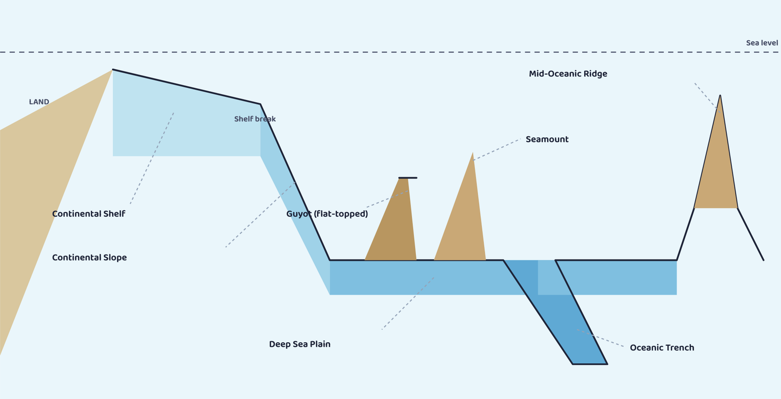
The ocean floor is divided into four major zones. Each one has its own typical gradient (how steeply it slopes) and depth range, and these two numbers are exactly what exam questions test.
| Zone | What it is | Gradient | Depth |
|---|---|---|---|
| Continental Shelf | Shallow, extended margin of a continent, covered by shallow seas and gulfs, the shallowest part of the ocean | ~1° or less | 30-600 m |
| Continental Slope | Connects the shelf to the deep ocean basin; marks the true end of the continent | 2°-5° | 200-3,000 m |
| Deep Sea Plain | Gently sloping, the flattest and smoothest region on earth, covered in fine clay and silt | almost flat | 3,000-6,000 m |
| Oceanic Deeps (Trenches) | The deepest, narrowest, steepest-sided parts of the ocean floor | very steep sides | 3-5 km deeper than the surrounding floor |
A continental margin is the submerged edge of a continent where it meets the deep ocean floor, made up of the continental shelf and the continental slope together.
The shelf ends at a steep drop called the shelf break. Its width averages 80 km, but shrinks to almost nothing off Chile and western Sumatra, and stretches to 1,500 km at the Siberian shelf (Arctic Ocean, the widest in the world). River, glacier and wind sediment piles up on shelves for so long that it becomes the source rock for fossil fuels.
The slope begins where the shelf’s floor suddenly drops away; canyons and trenches are common here. Oceanic deeps sit at the base of slopes and along island arcs, tied to active volcanoes and strong earthquakes, which is why they matter to the study of plate movement. 57 deeps are known: 32 Pacific, 19 Atlantic, 6 Indian.
Students often mix up the shelf and the slope. The shelf is the flat, shallow part right off the coast (gradient about 1°); the slope is the much steeper drop after it (gradient 2°-5°) that actually leads down to the deep ocean. Shallow and flat = shelf. Steep and dropping = slope.
4Minor Relief Features of the Ocean Floor
Besides the four major divisions, several smaller, but still important, features are scattered across the ocean floor.
| Feature | What it looks like | Real example |
|---|---|---|
| Mid-Oceanic Ridge | Two mountain chains separated by a large depression; peaks up to 2,500 m, some breaking the ocean surface | Iceland (part of the Mid-Atlantic Ridge) |
| Seamount | A pointed volcanic mountain rising from the seafloor, 3,000-4,500 m tall, that does not reach the surface | Emperor Seamount, an extension of the Hawaiian Islands, Pacific Ocean |
| Guyot | A seamount with a flat top, formed by gradual subsidence over time | More than 10,000 seamounts and guyots together, estimated in the Pacific Ocean alone |
| Submarine Canyon | A deep valley cutting across the shelf and slope, often continuing from the mouth of a large river | Hudson Canyon, the best known submarine canyon in the world |
| Atoll | A low, ring-shaped tropical island of coral reef surrounding a central lagoon | Found in tropical oceans; may enclose fresh, brackish or highly saline water |
Pointed and hidden = Seamount. Flat and hidden = Guyot. Ring and visible = Atoll.
All three are volcanic in origin, but this one detail (the shape of the top, and whether it breaks the surface) is what the exam actually asks you to tell apart.
5Temperature of Ocean Waters
Ocean water heats up from the sun exactly like land does, but it heats up, and cools down, more slowly. Four factors decide how warm or cold the water at any spot on the ocean surface is.
Latitude
Surface water temperature falls steadily from the equator towards the poles, because the amount of insolation (incoming solar energy) also falls towards the poles.
Unequal land and water
Oceans in the northern hemisphere touch a much larger area of land than oceans in the southern hemisphere, so they receive more heat and stay warmer overall.
Prevailing wind
Winds blowing from land out to sea drive warm surface water away from the coast, pulling cold water up from below (upwelling): this causes sideways (longitudinal) temperature differences. Winds blowing from the sea onto land do the opposite: they pile up warm water near the coast and raise the temperature there.
Ocean currents
Warm currents raise the temperature of cold areas; cold currents lower the temperature of warm areas. The warm Gulf Stream raises temperatures off the eastern coast of North America and the west coast of Europe, while the cold Labrador Current lowers temperatures off the north-east coast of North America.
These factors also explain why enclosed seas behave differently from the open ocean: in low latitudes, an enclosed sea (with little water exchange with the open ocean) records a higher temperature than the open sea beside it; in high latitudes, an enclosed sea records a lower temperature than the open sea.
6Distribution of Temperature
If you went down into the ocean from the surface, the temperature would fall, but not at a steady rate. Between about 100 and 400 m below the surface, there is a boundary zone where the temperature drops very quickly, extending down several hundred more metres. This zone is called the thermocline. Below it lies about 90% of all the ocean’s water, where temperatures are close to 0°C.
The thermocline is the layer of ocean water, usually starting 100-400 m below the surface, where temperature falls very rapidly with increasing depth, marking the boundary between the warm surface water and the cold deep water.
In the middle and low latitudes, this can be pictured as three layers stacked from surface to floor:
| Layer | Position | Thickness | Temperature |
|---|---|---|---|
| 1. Warm surface layer | Top layer | ~500 m | 20°C-25°C; year-round in the tropics, only in summer at mid-latitudes |
| 2. Thermocline layer | Below layer 1 | 500-1,000 m | Falls rapidly with depth |
| 3. Deep cold layer | Extends to the ocean floor | Rest of the ocean | Very cold throughout |
Near the Arctic and Antarctic circles, the surface water is already close to 0°C, so there is almost no change with depth: just one continuous layer of cold water from the surface all the way to the floor.
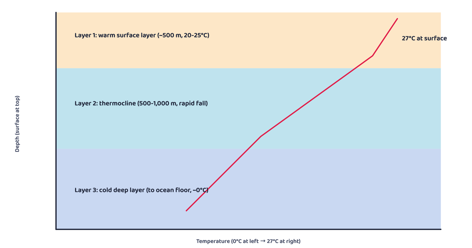
The average surface temperature of the oceans is about 27°C, falling towards the poles at roughly 0.5°C for every degree of latitude. Average temperature is about 22°C at 20° latitude, 14°C at 40°, and close to 0°C near the poles. The northern hemisphere’s oceans run warmer than the southern hemisphere’s (about 19°C average against 16°C), because of the unequal amount of land and water on the two sides of the equator. Curiously, the highest temperature of all is not recorded exactly at the equator, but slightly north of it.
The ocean’s maximum temperature is always found right at the surface, because that is where sunlight is received directly; the heat is then carried down into deeper layers by convection. Temperature drops very rapidly down to about 200 m, and only slows down after that.
7Salinity of Ocean Waters
Salinity is the total amount of dissolved salts present in sea water. It is calculated as the amount of salt, in grams, dissolved in 1,000 grams (1 kg) of sea water, and is usually written as parts per thousand (‰) or ppt.
Q. If evaporation leaves 35 g of salt dissolved in 1,000 g of sea water, what is its salinity?
Step 1: Salinity is the mass of salt per 1,000 g of sea water.
Step 2: Here, that mass is already 35 g.
Answer: Salinity = 35‰ (35 parts per thousand), close to the ocean’s actual average.
A salinity of 24.7‰ is treated as the upper limit for calling water “brackish.” Four factors affect the salinity of any part of the ocean:
| Water body | Salinity |
|---|---|
| Lake Van, Turkey | 330‰ |
| Dead Sea | 238‰ |
| Great Salt Lake | 220‰ |
8Distribution of Salinity
Salinity in the normal open ocean stays between 33‰ and 37‰. It can rise much higher where a sea is landlocked and evaporation is intense, or fall much lower where fresh water pours in.
| Water body | Salinity pattern | Reason |
|---|---|---|
| Red Sea | Up to 41‰ (high) | Landlocked, very high evaporation |
| Estuaries and the Arctic | 0-35‰, changes with the season | Seasonal freshwater and ice melt |
| Hot, dry regions | Up to 70‰ (very high) | Extremely high evaporation |
| North Sea | Higher than expected for its latitude | Salty water brought in by the North Atlantic Drift |
| Baltic Sea | Low | Large inflow of river water |
| Mediterranean Sea | High | High evaporation |
| Black Sea | Very low | Enormous freshwater inflow from rivers |
| Bay of Bengal | Lower than the Indian Ocean average | Inflow of river water |
| Arabian Sea | Higher than the Indian Ocean average | High evaporation, little fresh water inflow |
The Atlantic Ocean averages about 36‰, with its highest salinity (up to 37‰) between 15°-20° latitude and 20°W-60°W. The Pacific Ocean’s salinity varies mainly because of its huge size and shape. It falls from 35‰ to 31‰ in the western part of the northern hemisphere (fed by Arctic meltwater), and drops further to 33‰ after 15°-20° south. The Indian Ocean averages 35‰.
Salinity generally rises with depth. Surface salinity goes up when water is lost to ice formation or evaporation, and goes down when fresh water flows in from rivers. But at depth, salinity barely changes at all, because there is no way for water to be “lost” or salt to be “added” down there. The layer where salinity increases sharply with depth is called the halocline. Since higher salinity makes water denser, low-salinity water always floats above high-salinity water: this is called stratification by salinity.
The halocline is the layer of ocean water where salinity increases sharply with depth, separating the less salty surface water from the more salty, denser water below.
Salinity, temperature and density are all connected. A rise in salinity makes sea water denser, and denser water always sinks below lighter water, which is exactly why the low-salinity surface layer rests on top of the high-salinity deep layer, everywhere in the world’s oceans.
- Hydrological cycle = water moving between ocean, air and land forever; 91% of all water is in the oceans
- 4 major ocean-floor zones, coast to deepest: Continental Shelf (~1°, 30-600 m) → Continental Slope (2°-5°, 200-3,000 m) → Deep Sea Plain (3,000-6,000 m) → Oceanic Deeps (3-5 km deeper still)
- 5 minor relief features: Mid-Oceanic Ridge, Seamount (pointed, hidden), Guyot (flat, hidden), Submarine Canyon, Atoll (ring, visible)
- 4 temperature factors: latitude, land-water distribution, prevailing wind, ocean currents
- Temperature falls in 3 layers with depth: warm layer (~500 m) → thermocline (500-1,000 m, rapid fall) → cold deep layer; ~90% of ocean water is below the thermocline
- Average surface temperature ~27°C, falling ~0.5°C per degree of latitude towards the poles
- Salinity = grams of salt per 1,000 g of sea water, written in ‰; normal open ocean is 33-37‰
- Salinity rises with high evaporation (Red Sea, Mediterranean, Arabian Sea) and falls with river inflow (Baltic Sea, Black Sea, Bay of Bengal)
- Salinity increases with depth at the halocline; low-salinity water always floats above high-salinity water
- 1 markIdentify the element which is NOT a part of the hydrological cycle:
(a) Evaporation(b) Hydration(c) Precipitation(d) Condensation - 1 markThe average depth of the continental slope varies between:
(a) 2-20 m(b) 200-2,000 m(c) 20-200 m(d) 2,000-20,000 m - 1 markWhich one of the following is NOT a minor relief feature of the oceans?
(a) Seamount(b) Atoll(c) Oceanic Deep(d) Guyot - 1 markSalinity is expressed as the amount of salt, in grams, dissolved in sea water per:
(a) 10 g(b) 1,000 g(c) 100 g(d) 10,000 g - 1 markWhich one of the following is the smallest ocean?
(a) Indian Ocean(b) Arctic Ocean(c) Atlantic Ocean(d) Pacific Ocean - 1 markThe zone where ocean temperature falls most rapidly with depth is called the:
(a) Halocline(b) Shelf break(c) Thermocline(d) Continental margin - 1 markWhich ocean current lowers the temperature near the north-east coast of North America?
(a) Gulf Stream(b) North Atlantic Drift(c) Labrador Current(d) Equatorial Current
Reason (R): The Red Sea is landlocked and experiences very high evaporation.
Reason (R): Salinity never changes because of river water entering the sea.
Reason (R): A guyot is a seamount with a flat top, formed by gradual subsidence.
- 1 markWhy do we call the earth a “Blue Planet”?
- 1 markName the four major divisions of the ocean floor.
- 1 markWhat is a shelf break?
- 1 markName one example each of a mid-oceanic ridge and a seamount.
- 1 markWhat is salinity of sea water?
- 1 markWhat is a halocline?
- 2 marksWhat is a continental margin?
- 3 marksList out how many oceanic deeps have been explored so far, and how they are distributed among the oceans.
- 2 marksWhat is a thermocline?
- 3 marksWhen you move down into the ocean, what thermal layers would you encounter, and why does temperature vary with depth?
- 2 marksWhat is the salinity of sea water, and how is it measured?
- 3 marksDistinguish between a seamount, a guyot and an atoll.
- 5 marksHow are the various elements of the hydrological cycle interrelated?
- 5 marksExamine the factors that influence the temperature distribution of the oceans.
- 5 marksDescribe the four major divisions of the ocean floor, with their gradient and depth.
- 5 marksExplain the factors affecting the horizontal distribution of salinity in the world’s oceans, with examples.