Ocean Water
- Why ocean water is always moving, and the difference between its horizontal motion (currents and waves) and vertical motion (tides)
- How a wave carries energy forward without the water itself travelling, and the seven measurements used to describe one
- What actually causes a tide: the tug-of-war between the moon’s gravity and centrifugal force
- How to tell a semi-diurnal tide from a diurnal or mixed one, and a spring tide from a neap tide
- Why tides matter for navigation, harbours, and even electricity generation
- What drives an ocean current, how gyres form, and which named currents are warm and which are cold
- How currents quietly shape the climate of coastlines thousands of kilometres away
1Ocean Water in Motion
Ocean water never sits still. Its own physical properties, temperature, salinity and density, along with outside forces like the sun, the moon and the wind, keep it constantly moving. This movement takes two forms: horizontal motion and vertical motion.
| Type of motion | What it covers | What actually moves |
|---|---|---|
| Horizontal | Ocean currents and waves | In a current, the water itself travels from place to place. In a wave, only the wave train (energy) moves ahead, not the water |
| Vertical | Tides | Water rises and falls twice a day due to the sun and moon’s attraction; upwelling of cold subsurface water and sinking of surface water are also vertical motion |
An ocean current is the continuous flow of a huge amount of water in a definite direction. A wave is the horizontal motion of water in which the water itself does not travel forward, only the wave train does.
2Waves
A wave is energy, not water, moving across the ocean surface. As a wave passes, a water particle only travels in a small circle and ends up almost where it started. Wind is what supplies this energy: it makes waves travel across the ocean, and that energy is finally released on the shoreline. The motion of surface water rarely disturbs the still, deep bottom water of the ocean.
As a wave approaches the beach, friction with the sea floor slows it down. Once the water depth becomes less than half the wave’s wavelength, the wave breaks. This is why the largest waves are found in the open ocean: waves keep growing as they travel and absorb more energy from the wind.
Most waves are simply wind-driven. A breeze of two knots or less over calm water first raises small ripples; as wind speed increases, these ripples grow until white caps appear on breaking waves. A wave can travel thousands of kilometres before it finally rolls ashore, breaks, and dissolves as surf.
A wave’s size and shape reveal where it came from. Steep waves are usually young, formed by local wind nearby. Slow, steady waves have travelled from far away, possibly even from another hemisphere. The maximum height a wave reaches depends on the strength of the wind: how long it blows, and the area over which it blows in a single direction.
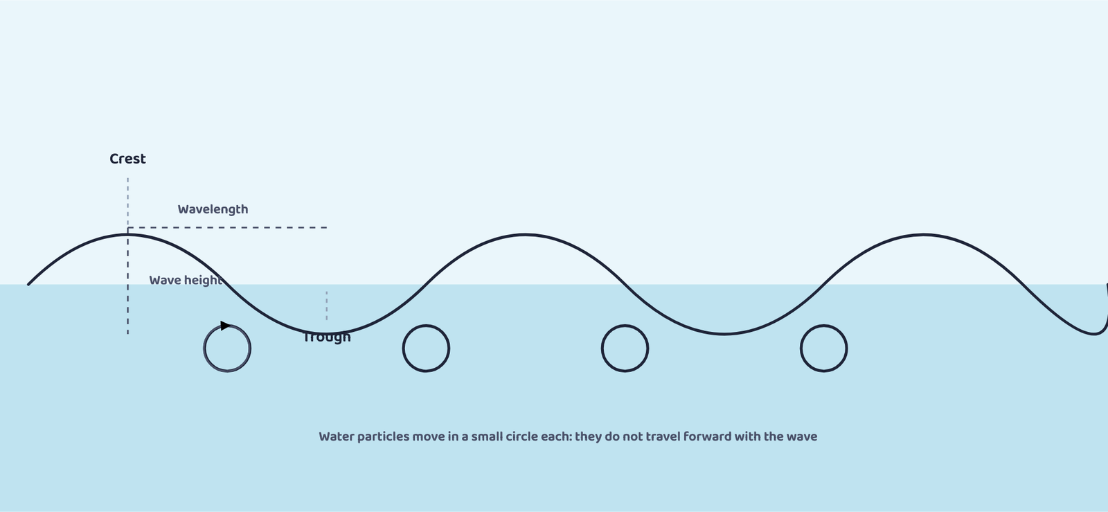
Wind pushes the water body forward while gravity pulls the crests of waves downward. The falling water then pushes the old trough upward, and the wave moves into a new position. So the actual motion of water beneath a wave is circular: things are carried up and forward as a wave approaches, and down and back as it passes.
3Tides: Definition and Causes
A tide is the periodical rise and fall of the sea level, once or twice a day, caused mainly by the gravitational attraction of the sun and the moon.
Do not confuse a tide with a surge: a surge is a movement of water caused by meteorological effects such as winds and changes in atmospheric pressure, and unlike tides, surges are irregular. Tides are studied in great spatial and temporal detail because they vary hugely in frequency, magnitude and height.
Two forces are responsible for tides. The moon’s gravitational pull is the major cause, and the sun’s gravitational pull is a lesser one. The second factor is centrifugal force, which acts to counterbalance gravity. Together, gravitational pull and centrifugal force create two tidal bulges on opposite sides of the earth:
The bulge facing the moon
Here, the moon’s gravitational pull is stronger than the centrifugal force, so there is a net force pulling water into a bulge towards the moon.
The bulge on the far side
Here, the moon’s pull is weaker because this side is farther away, so the centrifugal force dominates instead, creating a second bulge away from the moon.
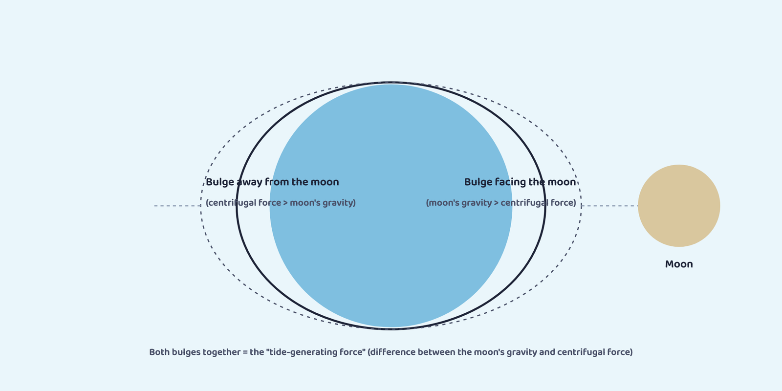
The tide-generating force is exactly this difference: the moon’s gravitational attraction minus the centrifugal force. On the earth’s surface, the horizontal tide-generating forces matter more than the vertical ones in actually creating these bulges.
Tidal bulges rise to a greater height over wide continental shelves, but become low when they strike mid-oceanic islands. The shape of bays and estuaries along a coastline can magnify tide intensity too: funnel-shaped bays change tidal magnitude sharply. When a tide is channelled between islands, or into bays and estuaries, it is called a tidal current.
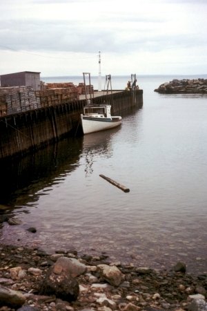
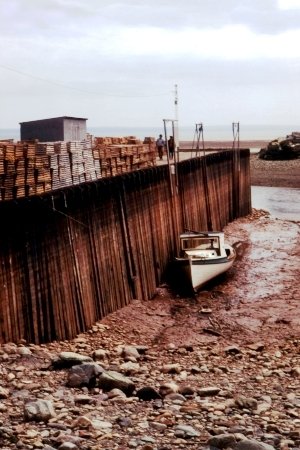
The highest tides in the world occur in the Bay of Fundy, Nova Scotia, Canada, where the tidal bulge is 15-16 m. Since there are two high and two low tides roughly every 24 hours, a tide must arrive within about a six-hour window. That works out to a rise of roughly 240 cm an hour (1,440 cm ÷ 6 hours), or about 4 cm every minute, fast enough that someone walking along a beach there can be caught out by the incoming water.
4Types of Tides
Tides vary in frequency, direction and movement from place to place and from time to time. They can be grouped based on how often they occur in a day, or based on the sun-moon-earth position.
Semi-diurnal tide: the most common pattern, with two high tides and two low tides each day; successive high or low tides are of approximately the same height.
Diurnal tide: only one high tide and one low tide each day, of approximately the same height.
Mixed tide: tides that vary in height, generally found along the west coast of North America and on many Pacific islands.
Spring tide: when the sun, the moon and the earth are in a straight line, the tide’s height is at its highest. This occurs twice a month, once around full moon and once around new moon.
Neap tide: about seven days after a spring tide, the sun and moon are at right angles to each other, so their gravitational pulls counteract one another. Although the moon’s pull is more than twice as strong as the sun’s, it is dampened by the sun’s opposing pull, giving the smallest tidal range.
A spring tide occurs when the sun, moon and earth are aligned, producing the highest tidal range. A neap tide occurs when the sun and moon are at right angles to the earth, producing the lowest tidal range.
| Term | When it happens | Effect on tides |
|---|---|---|
| Perigee | Once a month, when the moon’s orbit brings it closest to the earth | Unusually high and low tides; tidal range greater than normal |
| Apogee | About two weeks after perigee, when the moon is farthest from the earth | Moon’s gravitational force is limited; tidal ranges less than average |
| Perihelion | Around 3rd January every year, when the earth is closest to the sun | Tidal ranges much greater; unusually high and low tides |
| Aphelion | Around 4th July every year, when the earth is farthest from the sun | Tidal ranges much less than average |
Students often mix up the two pairs of terms. Perigee / Apogee are about the moon’s distance from the earth (monthly). Perihelion / Aphelion are about the earth’s distance from the sun (yearly). “P” for Perigee and Perihelion both mean the “closest” point in each pair.
The time between a high tide and the next low tide, when the water level is falling, is called the ebb. The time between a low tide and the next high tide, when the tide is rising, is called the flow or flood.
5Importance of Tides
Because tides are caused by earth-moon-sun positions that are known with great accuracy, tides can be predicted well in advance. This helps navigators and fishermen plan their activities around them.
Navigation
Tidal flows matter greatly for navigation. Tidal heights are especially important for harbours near rivers and within estuaries that have shallow “bars” at the entrance, which can prevent ships and boats from entering.
Desilting and cleaning estuaries
Tides help desilt sediments and remove polluted water from river estuaries, keeping them navigable and cleaner.
Generating electricity
Tides are used to generate electrical power in Canada, France, Russia and China. India has a 3 MW tidal power project under way at Durgaduani in the Sunderbans, West Bengal.
6Ocean Currents
An ocean current is like a river flowing within the ocean: a regular volume of water moving along a definite path and direction.
Ocean currents are shaped by two kinds of forces: primary forces, which start the water moving, and secondary forces, which influence how the currents then flow.
These large accumulations of water and the flow around them are called gyres. Gyres produce large circular currents in every ocean basin.
A gyre is a large circular system of ocean currents, formed when water accumulates under the influence of wind and the Coriolis force.
Secondary forces work through density. Water with high salinity is denser than water with low salinity, and cold water is denser than warm water. Denser water sinks, while lighter water rises. This is why cold-water currents form when polar water sinks and slowly moves towards the equator, while warm-water currents travel outward from the equator along the surface, flowing towards the poles to replace the sinking cold water.
7Types of Ocean Currents and Major Named Currents
| Classified by | Type | What it means |
|---|---|---|
| Depth | Surface currents | About 10% of all ocean water; the upper 400 m of the ocean |
| Deep water currents | The other 90%; move around ocean basins due to density and gravity variation; sink into deep basins at high latitudes, where cold temperature raises density | |
| Temperature | Cold currents | Bring cold water into warm-water areas; usually on the west coast of continents in low/middle latitudes (both hemispheres), and on the east coast in higher northern latitudes |
| Warm currents | Bring warm water into cold-water areas; usually on the east coast of continents in low/middle latitudes (both hemispheres); in the northern hemisphere also on the west coasts of continents at high latitudes |
Major currents are heavily influenced by the prevailing winds and the Coriolis force, which is why the oceanic circulation pattern roughly matches the earth’s atmospheric circulation pattern. Even without redrawing the world map of currents, the exam only ever asks you to place a named current correctly as warm or cold, and on which coast it flows:
| Ocean | Current | Type | Coast / region |
|---|---|---|---|
| Atlantic | Gulf Stream & North Atlantic Drift | Warm | East coast of North America, then north-east towards north-west Europe |
| Labrador Current | Cold | North-east coast of North America (Canada) | |
| Canary Current | Cold | West coast of north-west Africa | |
| Benguela Current | Cold | West coast of southern Africa | |
| Pacific | Kuroshio Current | Warm | East coast of Japan / East Asia |
| Oyashio Current | Cold | North-east coast of Asia (Kamchatka / Kuril region) | |
| California Current | Cold | West coast of North America | |
| Peru (Humboldt) Current | Cold | West coast of South America | |
| Indian | Agulhas Current | Warm | South-east coast of Africa |
| West Australian Current | Cold | West coast of Australia |
At higher latitudes, where wind flow is mostly cyclonic, the oceanic circulation follows the same pattern. In regions of strong monsoon flow, the monsoon winds influence how currents move. Because of the Coriolis force, warm currents from low latitudes deflect to the right in the northern hemisphere and to the left in the southern hemisphere.
Just like atmospheric circulation, oceanic circulation transports heat from one latitude belt to another: the cold waters of the Arctic and Antarctic move towards warmer tropical and equatorial regions, while the warm waters of the lower latitudes move poleward.
8Effects of Ocean Currents
Ocean currents have both direct and indirect effects on human activities, mostly through their influence on coastal climate.
| Coast | Current type | Climate effect |
|---|---|---|
| West coasts, tropical & subtropical latitudes (except near the equator) | Cold currents | Relatively low average temperature, narrow diurnal and annual range, fog, generally arid |
| West coasts, middle & higher latitudes | Warm currents | Distinct marine climate: cool summers, relatively mild winters, narrow annual temperature range |
| East coasts, tropical & subtropical latitudes | Warm currents (western margins of subtropical anti-cyclones) | Warm and rainy climate |
A frequently-asked question: “why are the world’s best fishing grounds found where warm and cold currents meet?” Answer: the mixing of warm and cold currents helps replenish oxygen and favours the growth of plankton, the primary food for fish, so fish populations concentrate exactly in these mixing zones.
- Two motions: horizontal (currents = water moves; waves = only energy moves) and vertical (tides)
- Waves: energy across the surface; water particles move in a small circle only; break when depth < half the wavelength
- 7 wave terms: crest, trough, height, amplitude, period, wavelength, speed, frequency
- Tides caused by moon’s gravity (major) + sun’s gravity (minor) vs. centrifugal force → 2 tidal bulges (facing moon, opposite side)
- By frequency: semi-diurnal (2 highs + 2 lows, most common) · diurnal (1 high + 1 low) · mixed (varying height, W. North America, Pacific islands)
- By sun-moon-earth position: spring tide (aligned, highest, twice a month) · neap tide (right angles, lowest, ~7 days after spring)
- Perigee/Apogee = moon’s distance from earth (monthly); Perihelion (~3 Jan)/Aphelion (~4 July) = earth’s distance from sun (yearly)
- Ebb = falling water between high→low tide; Flow/Flood = rising water between low→high tide
- Tides help: navigation, harbour planning, desilting estuaries, tidal electricity (Canada, France, Russia, China; India’s 3 MW Durgaduani project)
- Currents: primary forces (solar heating, wind, gravity, Coriolis) start them; secondary forces (density, from salinity + temperature) shape their vertical movement; gyres = large circular current systems
- By depth: surface currents (10%, upper 400 m) vs deep currents (90%, density/gravity-driven)
- By temperature: cold currents (west coasts, low/mid latitudes) vs warm currents (east coasts, low/mid latitudes)
- Named currents: Gulf Stream/N. Atlantic Drift, Kuroshio, Agulhas = warm; Labrador, Canary, Benguela, Oyashio, California, Peru, W. Australian = cold
- Currents shape coastal climate: cold-current west coasts = cool, arid, foggy; warm-current west coasts = marine climate; warm currents on east coasts = warm and rainy
- Warm + cold current mixing zones = world’s best fishing grounds (oxygen + plankton)
- 1 markThe upward and downward movement of ocean water is known as the:
(a) Tide(b) Current(c) Wave(d) None of the above - 1 markSpring tides are caused as a result of:
(a) The moon and sun pulling the earth gravitationally in the same direction(b) The moon and sun pulling the earth gravitationally in opposite directions(c) Indentation in the coastline(d) None of the above - 1 markThe distance between the earth and the moon is minimum when the moon is in:
(a) Aphelion(b) Perigee(c) Perihelion(d) Apogee - 1 markThe earth reaches its perihelion in:
(a) October(b) September(c) July(d) January - 1 markWhich of these is a warm ocean current?
(a) Labrador Current(b) Canary Current(c) Gulf Stream(d) Peru Current - 1 markSurface ocean currents make up about what share of all ocean water?
(a) 10%(b) 50%(c) 90%(d) 25% - 1 markA tide with only one high tide and one low tide per day is called a:
(a) Semi-diurnal tide(b) Mixed tide(c) Diurnal tide(d) Spring tide
Reason (R): During a neap tide, the sun and moon are at right angles to the earth, so their gravitational pulls counteract each other.
Reason (R): The Gulf Stream is a warm ocean current.
Reason (R): The mixing of warm and cold currents replenishes oxygen and favours the growth of plankton.
- 1 markWhat are waves?
- 1 markWhere do waves in the ocean get their energy from?
- 1 markWhat are tides?
- 1 markWhat is a gyre?
- 1 markName any two warm ocean currents and any two cold ocean currents.
- 1 markWhat is meant by the “drift” of a current?
- 2 marksHow are tides caused?
- 3 marksDistinguish between a spring tide and a neap tide.
- 2 marksHow are tides related to navigation?
- 3 marksDifferentiate between perigee/apogee and perihelion/aphelion.
- 2 marksWhat are the primary forces that influence ocean currents?
- 3 marksDistinguish between surface currents and deep water currents.
- 5 marksHow do currents affect temperature? Explain how they affect the temperature of coastal areas in north-west Europe.
- 5 marksWhat are the causes of ocean currents? Explain the role of primary and secondary forces.
- 5 marksDescribe the different types of tides based on their frequency of occurrence and their relation to the position of the sun, moon and earth.
- 5 marksExplain the importance of tides to human activities, with examples.
- 3 marksVisit a lake or pond, throw a stone into it, and describe what you observe about how waves are generated and how they travel outward.
- 3 marksUsing a globe or an atlas map of ocean currents, discuss why certain currents are described as warm and others as cold, and why currents deflect direction in certain places.