c. fourteenth to sixteenth century
Vijayanagara, “city of victory”, named both a city and an empire, founded in the fourteenth century, stretching at its peak from the river Krishna to the tip of the peninsula. Sacked in 1565 and abandoned soon after, it survived only in local memory as Hampi, named for the mother goddess Pampadevi, until oral tradition, archaeology, inscriptions and other records let scholars piece the empire back together.
1 The Discovery of Hampi
The ruins were brought to light in 1800 by Colonel Colin Mackenzie, an East India Company engineer and antiquarian who prepared the site’s first survey map, drawing much of his early information from the memories of priests at the Virupaksha temple and the Pampadevi shrine. From 1856, photographers began recording the monuments; from 1836, epigraphists collected the many inscriptions at Hampi’s temples. Historians then combined all of this with foreign travellers’ accounts and literature in Telugu, Kannada, Tamil and Sanskrit.
Born 1754, Mackenzie became India’s first Surveyor General in 1815, holding the post until his death in 1821. He collected local histories to understand India’s past and ease colonial governance, writing that the south had struggled “under the miseries of bad management” before British rule, and that studying Vijayanagara could give the Company “much useful information on many of these institutions, laws and customs whose influence still prevails.”
2 Rayas, Nayakas and Sultans
Tradition and inscriptions credit two brothers, Harihara and Bukka, with founding the empire in 1336, ruling over speakers of many languages and many faiths. Contemporaries called it the karnataka samrajyamu, not “Vijayanagara Empire”, a term historians coined later.
On its northern frontier, Vijayanagara competed with the Deccan Sultans and the Gajapati rulers of Orissa (“lord of elephants”) for fertile river valleys and overseas trade revenue, even as architectural ideas passed freely between them.
Vijayanagara’s own popular tradition named its rivals by what they commanded: the Deccan Sultans as ashvapati (lord of horses), and its own rayas as narapati (lord of men).
The empire absorbed regions with strong prior temple traditions, the Cholas’ Tamil Nadu and the Hoysalas’ Karnataka, home to the Brihadishvara temple at Thanjavur and the Chennakeshava temple at Belur, and Vijayanagara’s own rulers, who styled themselves rayas, built on and extended these traditions.
2.1 Kings and traders
Cavalry warfare made imported horses from Arabia and Central Asia essential; Arab traders and local kudirai chettis (horse merchants) controlled this trade until 1498, when the Portuguese arrived on the west coast, their superior muskets making them major players almost immediately. Vijayanagara’s own markets in spices, textiles and precious stones were themselves a mark of the city’s status, and that trade revenue fed the state’s prosperity directly.
From the Amuktamalyada, his Telugu work on statecraft: “A king should improve the harbours of his country and so encourage its commerce that horses, elephants, precious gems, sandalwood, pearls and other articles are freely imported… He should arrange that the foreign sailors who land in his country on account of storms, illness and exhaustion are looked after in a suitable manner… Make the merchants of distant foreign countries who import elephants and good horses be attached to yourself… Then those articles will never go to your enemies.”
2.2 The apogee and decline of the empire
Do not write that Vijayanagara and the Deccan Sultanates were locked in constant religious hostility. Krishnadeva Raya backed rival claimants inside the Sultanates and took the title “establisher of the Yavana kingdom” (Yavana = Sanskrit for Greeks and other northwestern peoples); the Sultan of Bijapur once helped settle a Vijayanagara succession dispute. Talikota happened because Rama Raya’s own policy of playing one Sultan against another finally pushed them into an alliance against him, not because of any permanent state of war.
2.3 The rayas and the nayakas
Military chiefs called nayakas, usually Telugu- or Kannada-speaking, controlled forts and armed followers and often moved with settler peasants in tow; many submitted to Vijayanagara, but rebellion was common.
The amara-nayaka system, likely derived from the Delhi Sultanate’s iqta system, gave amara-nayakas territory to govern on the raya’s behalf. They collected taxes from peasants, craftspersons and traders, kept part of the revenue for themselves and to maintain a fixed contingent of horses and elephants (giving the kings an effective combined fighting force), and used some revenue for temples and irrigation. They sent annual tribute and appeared personally at court with gifts; the king periodically transferred them between territories to keep them in check. Amara likely derives from Sanskrit samara (battle), and echoes the Persian amir (noble).
Through the seventeenth century many amara-nayakas broke away as independent kings, which hastened the collapse of the central imperial structure.
3 Vijayanagara: the Capital and its Environs
Sources include royal and nayaka inscriptions recording temple donations, and traveller accounts: Nicolo de Conti (Italy), Abdur Razzaq (Persian ambassador), Afanasii Nikitin (Russia), all fifteenth century, and Duarte Barbosa, Domingo Paes and Fernao Nuniz (Portugal), sixteenth century.
Domingo Paes: “The size of this city I do not write here, because it cannot all be seen from any one spot, but I climbed a hill whence I could see a great part of it… What I saw from thence seemed to me as large as Rome, and very beautiful to the sight; there are many groves of trees within it, in the gardens of the houses, and many conduits of water which flow into the midst of it, and in places there are lakes.”
3.1 Water resources
The city sits in a natural basin formed by the Tungabhadra, ringed by granite hills, in one of the peninsula’s most arid zones, which made storing rainwater essential. Embankments across the hill streams created reservoirs; the most important, the early-fifteenth-century Kamalapuram tank, irrigated nearby fields and fed the “royal centre” by channel. The Hiriya canal, drawing from a Tungabhadra dam and probably built under the Sangama dynasty, irrigated the valley separating the “sacred centre” from the “urban core”.
Paes on a tank Krishnadeva Raya built: “The king made a tank… at the mouth of two hills so that all the water which comes from either one side or the other collects there… water comes to it from more than three leagues (approximately 15 kilometres) by pipes… In order to make this tank the said king broke down a hill… In the tank I saw so many people at work that there must have been fifteen or twenty thousand men, looking like ants…”
3.2 Fortifications and roads
Abdur Razzaq described seven lines of forts encircling not just the city but its agricultural hinterland and forests: the outermost wall linked the surrounding hills, built with wedge-shaped stone blocks needing no mortar, earth-and-rubble fill inside, and projecting square or rectangular bastions.
Do not assume fortified areas held only buildings. Abdur Razzaq noted “between the first, second and the third walls there are cultivated fields, gardens and houses”, confirmed by Paes and by present-day archaeology. Enclosing farmland was a deliberate, expensive alternative to the usual siege defence of large granaries: a besieged Vijayanagara could feed itself from land inside its own walls.
A second fortification line ringed the urban core, a third the royal centre, and each major building complex there had its own high wall. Gateways used the arch and dome of Indo-Islamic architecture, introduced by Turkish Sultans and adapted through interaction with local building practice. Roads wound through valleys avoiding rocky ground, and major ones ran from temple gateways lined with bazaars.
3.3 The urban core
Almost nothing survives of ordinary housing. Fine Chinese porcelain found in the urban core’s north-east corner, also a Muslim residential quarter with tombs and mosques echoing local mandapa styles, suggests wealthy traders lived there. Barbosa described the vanished ordinary housing: “thatched, but nonetheless well built and arranged according to occupations, in long streets with many open places.” Numerous small shrines scattered through the core point to many parallel cults, while wells and temple/rainwater tanks served ordinary residents’ water needs.
4 The Royal Centre
Located in the south-west, the royal centre still held over 60 temples, since patronage of temples and cults was central to how rulers legitimised their power. About 30 complexes are identified as palaces, large but not ritual in function; unlike temples, built entirely of masonry, palace superstructures used perishable materials, which is why so little survives of them today.
The “king’s palace” enclosure, the largest, has no definitive evidence of being a royal residence, but holds two of the most striking platforms: the “audience hall”, with closely spaced wooden-pillar slots leaving little clear floor space (so its exact use is unclear), and the mahanavami dibba itself, rising from an 11,000 sq ft base to 40 ft, once supporting a wooden structure, its base carved with relief panels.
“These buildings have two platforms one above the other, beautifully sculpted… On the upper platform… in this House of Victory the king has a room made of cloth… where the idol has a shrine… and in the other in the middle is placed a dais on which stands a throne of state, (the crown and the royal anklet)…”
Rituals here likely coincided with Mahanavami (“the great ninth day”) of the ten-day autumn festival known elsewhere as Dusehra, Durga Puja or Navaratri: worship of the image and the state horse, animal sacrifice, dances, wrestling, processions of caparisoned horses, elephants and chariots, and ritual presentations by nayakas and subordinate kings, culminating in a final army inspection where nayakas delivered gifts and tribute. Whether the surviving platform could actually have hosted these crowds is genuinely disputed; scholars note the surrounding space looks too small for the scale of procession described, so the structure remains, in the chapter’s own words, an enigma.
4.2 Other buildings in the royal centre
The Lotus Mahal, named by nineteenth-century British travellers (a name historians are not certain fits its actual use, possibly a council chamber per a Mackenzie-era map), sits near the so-called “elephant stables”, whose actual function is also debated. The Hazara Rama temple, likely reserved for the king’s family, has lost its central images but keeps sculpted wall panels of scenes from the Ramayana. Even after the sack of Vijayanagara, nayakas across the region kept building in the same palatial traditions, many of which survive today.
5 The Sacred Centre
5.1 Choosing a capital
At the rocky northern end of the city, local tradition places the monkey kingdom of Vali and Sugriva from the Ramayana; another tradition holds that Pampadevi, the local mother goddess, did penance here to marry Virupaksha, the kingdom’s guardian deity and a form of Shiva, a marriage still celebrated annually at the Virupaksha temple. Pre-Vijayanagara Jaina temples also stand among these hills, so multiple sacred traditions converged here before the empire even existed.
Temple-building in the region traces back through the Pallavas, Chalukyas, Hoysalas and Cholas: temples doubled as centres of learning and, through land grants, as economic hubs, while rulers used temple patronage to link themselves to the divine. Vijayanagara kings claimed to rule on behalf of Virupaksha, signing royal orders “Shri Virupaksha” in Kannada script, and took the title Hindu Suratrana, a Sanskritised form of the Arabic “Sultan” meaning literally “Hindu Sultan”. They innovated too: royal portrait sculpture now appeared inside temples, and royal temple visits became major state occasions attended by the empire’s nayakas.
5.2 Gopurams and mandapas
New architectural scale marked this period: raya gopurams (royal gateways) often dwarfed the central shrine’s own tower, announcing the temple’s presence from far off and displaying the ruler’s command of resources, skill and technique. Temples also grew elaborate mandapas (pavilions) and long pillared corridors.
Virupaksha temple
- Earliest shrine dates to the ninth-tenth centuries, substantially enlarged once the empire was founded
- Krishnadeva Raya built the hall before the main shrine to mark his accession, decorated with carved pillars, and is credited with the eastern gopuram
- These additions left the original central shrine occupying only a small part of the whole complex
- Halls served many functions: some let images watch music, dance and drama; some hosted divine weddings; some held swings for the deities, using special images distinct from the main shrine’s
Vitthala temple
- Principal deity Vitthala, a Vishnu form usually worshipped in Maharashtra, imported here, showing how Vijayanagara’s rulers deliberately blended regional traditions into one imperial culture
- A unique shrine built in the shape of a stone chariot
- A chariot street runs straight from the gopuram, paved with stone slabs and lined with pillared pavilions where merchants traded
Nayakas continued and elaborated both fortification and temple-building traditions after the empire’s fall; some of the era’s most spectacular gopurams, such as at Madurai, are actually nayaka work, not Vijayanagara’s own.
6 Plotting Palaces, Temples and Bazaars
After Mackenzie’s initial surveys, information accumulated from traveller accounts and inscriptions; the ASI and the Karnataka Department of Archaeology and Museums preserved the site through the twentieth century, and Hampi was recognised as a site of national importance in 1976. In the early 1980s an intensive, decades-long documentation project began.
The site was divided into 25 squares, each lettered; each square was subdivided into smaller squares, and those again into still smaller units, painstakingly recovering traces of thousands of structures, from tiny shrines to elaborate temples, plus roads, paths and bazaars, the latter identified mainly from surviving pillar bases and platforms.
Scholars John M. Fritz, George Michell and M.S. Nagaraja Rao, who worked at the site for years, wrote: “In our study of these monuments of Vijayanagara we have to imagine a whole series of vanished wooden elements, columns, brackets, beams, ceilings, overhanging eaves, and towers, decorated with plaster and painted, perhaps brightly.” Only stone survives; travellers’ written descriptions are what let historians reconstruct the rest.
Paes: “In this street live many merchants, and there you will find all sorts of rubies, and diamonds, and emeralds, and pearls, and seed-pearls, and cloths, and every other sort of thing there is on earth… Then you have there every evening a fair where they sell many common horses and nags, and also many citrons, and limes, and oranges, and grapes, and every other kind of garden stuff.” He called it “the best-provided city in the world”; Fernao Nuniz described markets “overflowing with abundance of fruits… all very cheap”, with mutton, pork, venison, partridges and more freely sold.
7 Questions in Search of Answers
Surviving buildings reveal defence needs, construction methods, materials, and the spread of ideas when compared across sites, and they carry symbolic meaning that only makes sense alongside literature, inscriptions and popular tradition. What they cannot tell us is what ordinary men, women and children, the vast majority who actually lived in and around the city, thought of any of it: would they have had access to the royal or sacred centres at all? Did the sculpture’s symbolism mean anything to a passer-by? Nor can buildings alone answer who actually designed and built them: which masons, stonecutters and sculptors, whether any were war captives, what wages they earned, who supervised construction, or where materials were sourced and how they were moved. These remain open questions for further research, not things the standing ruins can settle by themselves.
8 Timelines and Revision
| Timeline 1 · major political developments (dates approximate; ? = uncertain) | |
|---|---|
| c. 1200-1300 | Establishment of the Delhi Sultanate (1206) |
| c. 1300-1400 | Establishment of the Vijayanagara Empire (1336?); Bahmani kingdom (1347); Sultanates in Jaunpur, Kashmir, Madura |
| c. 1400-1500 | Gajapati kingdom of Orissa (1435); Sultanates of Gujarat and Malwa; Sultanates of Ahmadnagar, Bijapur and Berar (1490) |
| c. 1500-1600 | Portuguese conquest of Goa (1510); collapse of the Bahmani kingdom and emergence of Golconda (1518); Mughal Empire founded by Babur (1526) |
| Timeline 2 · discovery and conservation of Vijayanagara | |
|---|---|
| 1800 | Colin Mackenzie visits Vijayanagara |
| 1856 | Alexander Greenlaw takes the first detailed photographs at Hampi |
| 1876 | J.F. Fleet begins documenting the site’s temple-wall inscriptions |
| 1902 | Conservation begins under John Marshall |
| 1986 | Hampi declared a UNESCO World Heritage Site |
- Vijayanagara means both city and empire, founded 1336, sacked 1565, remembered locally as Hampi until Mackenzie’s 1800 survey.
- Four dynasties ruled in turn: Sangama, Saluva, Tuluva (Krishnadeva Raya’s peak), Aravidu after Talikota.
- Talikota/Rakshasi-Tangadi followed from Rama Raya’s own shifting alliances, not from permanent Hindu-Muslim conflict; Vijayanagara and the Sultanates cooperated as often as they fought.
- The amara-nayaka system, borrowed from the Delhi Sultanate’s iqta, tied military service and revenue collection together, and its breakdown into independent nayaka kingdoms weakened the empire’s centre.
- The city fortified farmland inside its walls, an expensive alternative to granaries, to survive long sieges.
- Three zones: sacred centre (Virupaksha, Pampadevi, pre-existing sacred hills), royal centre (60+ temples, mahanavami dibba, Lotus Mahal), urban core (bazaars, ordinary housing, mostly lost).
- Gopurams grew to imperial scale under the rayas; the mahanavami dibba’s exact ritual use is still genuinely disputed among scholars.
- Reconstructing Vijayanagara used inscriptions, traveller accounts (Paes, Nuniz, Abdur Razzaq, Nikitin) and, from the 1980s, an intensive grid-square mapping survey.
- Buildings answer questions about defence, technique and symbolism, but not about ordinary people’s lived experience or the labourers who actually built the city.
- 1 markWho founded the Vijayanagara Empire, and in what year?
- 1 markWhat was the karnataka samrajyamu?
- 1 markWhat is an amara-nayaka?
- 1 markWhat title did the Vijayanagara kings take that Sanskritised the Arabic word for “Sultan”?
- 1 markWho was Colin Mackenzie?
- 2 marksName the four ruling dynasties of Vijayanagara in order.
- 2 marksWhat is a raya gopuram, and what did its scale signal?
- 2 marksWhat were the Kamalapuram tank and the Hiriya canal used for?
- 2 marksWhat is a mahanavami dibba, and why is its exact use still debated?
- 3 marksWhat methods have been used to study the ruins of Hampi over the last two centuries?
- 3 marksHow were the water requirements of Vijayanagara met?
- 3 marksWhat were the advantages and disadvantages of enclosing agricultural land within the city’s fortified area?
- 3 marksDescribe the amara-nayaka system and how it eventually weakened the empire.
- 3 marksWhy do you think Vijayanagara and the Deccan Sultanates cooperated as often as they fought?
- 3 marksWhat can the Virupaksha and Vitthala temples tell us about how Vijayanagara’s rulers used religious patronage?
- 3 marksWhat questions about Vijayanagara can surviving buildings not answer?
- 5 marksDiscuss whether the term “royal centre” is an appropriate description for the part of Vijayanagara it names.
- 5 marksDiscuss the ways in which the rulers of Vijayanagara adopted and adapted earlier traditions of ritual architecture.
- 5 marksDescribe the fortifications of Vijayanagara and discuss why they took the particular form they did.
- 5 marksDiscuss the ways in which rulers, traders and temples were connected in the Vijayanagara economy.
- 5 marksTrace the discovery and conservation of Vijayanagara from Mackenzie’s 1800 visit to the 1980s mapping project.
- 5 marksWhat was the significance of the rituals associated with the mahanavami dibba, and what problems do historians face in reconstructing them?
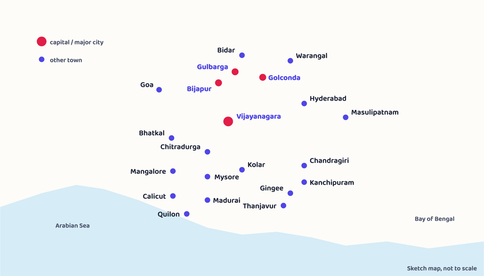
- 5 marksOn an outline map of India, plot Vijayanagara, Bijapur, Golconda, Ahmadnagar and Madurai, and describe the location of Rakshasi-Tangadi (Talikota).
- 1 markVijayanagara was sacked in the battle of:
(a) Panipat(b) Talikota(c) Plassey(d) Haldighati - 1 markKrishnadeva Raya’s work on statecraft, the Amuktamalyada, was written in:
(a) Sanskrit(b) Kannada(c) Telugu(d) Tamil - 1 markThe guardian deity of Vijayanagara, in whose name royal orders were signed, was:
(a) Vitthala(b) Virupaksha(c) Jagannatha(d) Vishnu - 1 markThe amara-nayaka system is believed to have been derived from the Delhi Sultanate’s:
(a) mansabdari system(b) iqta system(c) zamindari system(d) jagirdari system - 1 markFine Chinese porcelain found in the urban core’s north-east corner suggests this area housed:
(a) temple priests(b) rich traders(c) royal guards(d) agricultural labourers - 1 markHampi was declared a UNESCO World Heritage Site in:
(a) 1902(b) 1976(c) 1986(d) 1998
Choose: (a) both A and R are true and R explains A; (b) both true but R does not explain A; (c) A true, R false; (d) A false, R true.
Reason (R): This let the city sustain itself with food during a long siege instead of relying only on stored granaries.
Reason (R): Krishnadeva Raya supported claimants to power within the Sultanates, and the Sultan of Bijapur once intervened to settle a Vijayanagara succession dispute.