Sustainable
Development
- The difference between sectoral and regional planning, and why NITI Aayog replaced the Planning Commission
- What target area and target group planning are, with the Hill Area and Drought Prone Area Programmes
- How the Bharmaur tribal area was developed under an Integrated Tribal Development Project
- How the idea of “development” grew from pure economic growth into sustainable development
- The Indira Gandhi Canal story: how it transformed a desert, and the environmental problems it created
- The seven measures needed to make the Indira Gandhi Canal command area sustainable
1 Planning in India
Planning means thinking through a problem, drawing up a scheme or programme, and then carrying out a set of actions to reach a goal. In this chapter it is used specifically for economic development planning, a deliberate, thought-out process, unlike the old “hit-and-trial” method of reform and reconstruction.
Planning is the process of thinking, formulating a scheme or programme, and implementing a set of actions to achieve a goal, here the goal of economic development.
There are two broad approaches to planning:
Sectoral planning
- Formulating and implementing schemes for the development of a sector of the economy
- Example sectors: agriculture, irrigation, manufacturing, power, construction, transport, communication, social infrastructure and services
Regional planning
- Development is never uniform over space: some areas develop faster, some lag behind
- Planners take a spatial view and design plans to reduce this regional imbalance
1.1 From the Planning Commission to NITI Aayog
After Independence, India adopted centralised planning. This gradually gave way to decentralised, multi-level planning, with plan formulation shared between the Centre, State and district levels. Responsibility for this rested with the Planning Commission.
The single most likely one-line fact from this section: on 1 January 2015, the Planning Commission was replaced by the NITI Aayog (National Institution for Transforming India). NITI Aayog’s job is to involve the States in economic policy-making and to give strategic and technical advice to the Central and State governments.
2 Target Area Planning
About one-and-a-half decades of planning experience showed that regional imbalances in economic development were only getting worse. Sometimes even a resource-rich region stayed backward, because development also needs technology and investment, not just resources. To fix this, the Planning Commission introduced two new approaches: the target area approach and the target group approach.
Target area planning directs development programmes at a specific backward area. Target group planning directs programmes at a specific backward group of people, wherever they live.
| Approach | Aimed at | Examples named in the chapter |
|---|---|---|
| Target area | A backward region | Command Area Development Programme, Drought Prone Area Programme, Desert Development Programme, Hill Area Development Programme |
| Target group | A backward group of people | Small Farmers Development Agency (SFDA), Marginal Farmers Development Agency (MFDA) |
In the 8th Five Year Plan, special area programmes were designed to develop infrastructure in hill areas, north-eastern states, tribal areas and other backward areas.
2.1 Hill Area Development Programme
Initiated during the 5th Five Year Plan, this programme covered 15 hilly districts: every hilly district of Uttar Pradesh (now Uttarakhand), the Mikir Hills and North Cachar Hills of Assam, Darjeeling district of West Bengal, and Nilgiri district of Tamil Nadu. In 1981, the National Committee on Development of Backward Areas recommended that any hill area above 600 m in height, not already covered by a tribal sub-plan, be treated as a backward hill area.
These programmes aimed to use the hill areas’ own resources by developing horticulture, plantation agriculture, animal husbandry, poultry, forestry and small-scale and village industry.
2.2 Drought Prone Area Programme (DPAP)
This programme began in the 4th Five Year Plan to give employment to people in drought-prone areas and to create productive assets. It started out emphasising labour-intensive civil works, but later shifted focus to irrigation projects, land development, afforestation, grassland development and basic rural infrastructure: electricity, roads, market and credit facilities.
A review by the National Committee on Development of Backward Areas found the programme too narrowly focused on agriculture and allied sectors. Since growing population is forcing people onto marginal land, causing ecological degradation, the review called for alternative employment in drought-prone areas and an integrated watershed development approach at the micro-level, restoring the balance between water, soil, plants, and the human and animal population.
Broadly, India’s drought-prone belt lies over the semi-arid and arid parts of Rajasthan, Gujarat, western Madhya Pradesh, the Marathwada region of Maharashtra, the Rayalseema and Telangana plateaus of Andhra Pradesh, the Karnataka plateau, and the interior highlands of Tamil Nadu. Punjab, Haryana and north-Rajasthan, though in this belt, are largely protected because irrigation has spread through them.
3 Case Study: Integrated Tribal Development Project, Bharmaur
Bharmaur is a target-area example brought to life: a real tribal region, developed under a real plan.
| Fact | Detail |
|---|---|
| Location | Bharmaur and Holi tehsils, Chamba district, Himachal Pradesh |
| Coordinates / area | 32°11’N-32°41’N, 76°22’E-76°53’E; about 1,818 sq km; 1,500 m-3,700 m above sea level |
| Surrounded by | Pir Panjal (north) and Dhaula Dhar (south), meeting near Rohtang Pass |
| Drainage | The Ravi and its tributaries, the Budhil and the Tundahen, carving the region into four divisions: Holi, Khani, Kugti, Tundah |
| Climate | Mean temperature 4°C in January, 26°C in July; freezing conditions and snowfall in winter |
| Notified tribal area since | 21 November 1975 |
| People | The Gaddi tribe, who practise transhumance and speak the Gaddiali dialect |
| 2011 census | Population 39,113; density 21 persons/sq km, one of Himachal Pradesh’s most backward areas |
| Economy | Subsistence agriculture and sheep/goat rearing |
Development began in the 1970s once the Gaddis were listed among the Scheduled Tribes. A tribal sub-plan was introduced in 1974 under the 5th Five Year Plan, and Bharmaur became one of five Integrated Tribal Development Projects (ITDP) in Himachal Pradesh. The plan gave top priority to transport and communication, agriculture and allied activities, and social and community services.
A 30-word “social benefits of ITDP” question is asked directly from the book. Answer with three facts: literacy rose sharply, female literacy went from 1.88% (1971) to 65% (2011), and child marriage declined.
What ITDP achieved
- Infrastructure: schools, healthcare, drinking water, roads, communication, electricity
- Literacy up sharply; female literacy 1.88% (1971) → 65% (2011)
- Gender gap in literacy narrowed; child marriage declined
- Cultivation of pulses and cash crops increased over the last 3 decades of the 20th century
What is still missing
- Benefits went mainly to villages along the Ravi in Holi and Khani
- Remote villages of Tundah and Kugti still lack sufficient infrastructure
- Farming still uses traditional technology
- Pastoralism is declining: only about 1 in 10 households still practise transhumance
The Gaddis remain highly mobile even so: a sizeable section still migrates every winter to Kangra and nearby areas to earn a living from wage labour.
4 Development and Sustainable Development
“Development” describes both the state of a society and the changes it goes through. For most of human history this state was shaped by the interaction between human societies and their bio-physical environment, driven by the level of technology and the institutions a society builds.
Sustainable development is “development that meets the needs of the present without compromising the ability of future generations to meet their own needs”, the definition given by the Brundtland Report (1987).
Two books raised global fear about the environment: Ehrlich’s The Population Bomb (1968) and Meadows and others’ The Limits to Growth (1972). Responding to growing world concern, the United Nations set up the World Commission on Environment and Development (WCED), chaired by Norwegian Prime Minister Gro Harlem Brundtland. Its 1987 report, known as the Brundtland Report, was titled Our Common Future.
“1968 problem books, 1987 solution report.”
Ehrlich (1968) and Meadows (1972) named the problem; the Brundtland Report (1987) gave the answer: the definition of sustainable development that is still used today.
Sustainable development takes care of the ecological, social and economic aspects of development at the same time. It conserves resources so future generations can use them too, treating the whole of humankind as sharing one common future.
5 Case Study: Indira Gandhi Canal Command Area
The Indira Gandhi Canal, earlier called the Rajasthan Canal, is one of India’s largest canal systems and the chapter’s own worked example of sustainable development in action, both its gains and its costs.
The canal originates at the Harike barrage in Punjab and runs roughly parallel to the Pakistan border, about 40 km away, through the Thar Desert (Marusthali) of Rajasthan. Its total planned length is 9,060 km, serving a culturable command area of 19.63 lakh hectares, about 70% by the flow system, the rest by lift (all lift canals start from the main canal’s left bank; the right-bank canals are flow channels).
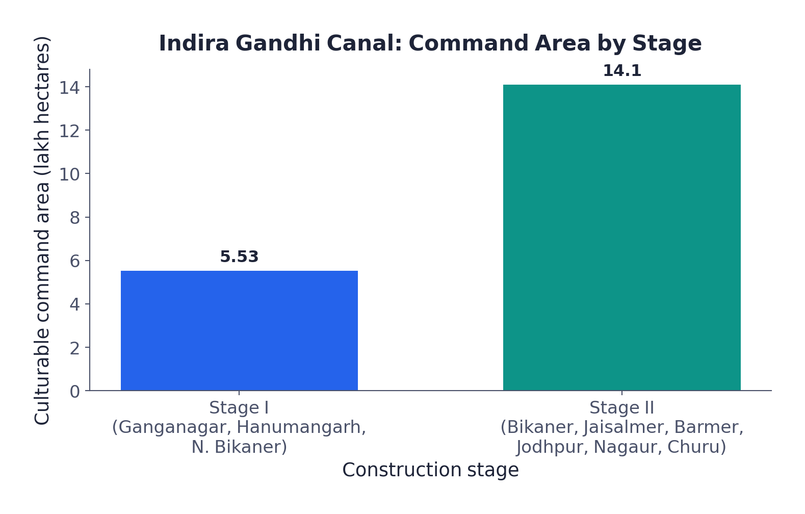
| Stage I | Stage II | |
|---|---|---|
| Districts | Ganganagar, Hanumangarh, northern Bikaner | Bikaner, Jaisalmer, Barmer, Jodhpur, Nagaur, Churu |
| Terrain | Gently undulating | Desert with shifting sand dunes; up to 50°C in summer |
| Command area | 5.53 lakh ha | 14.10 lakh ha |
| Irrigation began | Early 1960s | Mid-1980s |
Canal irrigation transformed the region’s ecology, economy and society, both for the better and for the worse.
Positive impact
- Soil moisture available for longer periods
- Afforestation and pasture-development programmes greened the land
- Wind erosion and canal siltation reduced
- Cultivated area and cropping intensity increased
Negative impact
- Intensive irrigation and excess water use caused waterlogging
- And soil salinity
- Both threaten the long-run sustainability of agriculture in the region
Students often write only “irrigation increased crop yield” for this case study and stop there. The chapter’s own point is sustainability: intensive irrigation gave a first burst of higher agricultural and livestock productivity, but the same intensive irrigation is what caused waterlogging and soil salinity: the gain and the problem come from the same cause.
Soil moisture, once the limiting factor for crops here, is no longer scarce, so traditional crops like gram, bajra and jowar have been replaced by water-demanding crops: wheat, cotton, groundnut and rice.
6 Measures for Promotion of Sustainable Development
Scholars have questioned the ecological sustainability of the Indira Gandhi Canal project, and the region’s own development over the last four decades, with its degraded physical environment, has largely proved them right. The book proposes seven measures to promote sustainable development in the command area; five of the seven are aimed squarely at restoring ecological balance.
Water management policy
Strict implementation: protective irrigation in Stage I, extensive irrigation and pasture development in Stage II
Cropping pattern
Avoid water-intensive crops; encourage plantation crops such as citrus fruits
CAD programmes
Lining of water courses, land development and levelling, and warabandi (equal distribution of canal water in an outlet’s command area) to cut conveyance loss
Reclamation
Reclaim areas already affected by waterlogging and soil salinity
Eco-development
Afforestation, shelterbelt plantation and pasture development, especially needed in Stage II’s fragile environment
Social sustainability
Adequate financial and institutional support for land allottees from poor economic backgrounds
Economic sustainability
Diversify beyond agriculture and animal husbandry; build functional links between basic villages, agro-service centres and market centres
Warabandi is a system for the equal distribution of canal water among all users in the command area of one outlet, so no farmer along the channel gets more or less than a fair turn.
Five of the Indira Gandhi Canal’s seven sustainability measures are about restoring ecology, not growing more crops, a direct reminder that the canal’s own success created the problem these measures now have to fix.
- NITI Aayog replaced the Planning Commission on 1 January 2015
- Two planning approaches: sectoral (by sector) and regional (spatial, to cut regional imbalance)
- Target area programmes: Command Area Development, Drought Prone Area, Desert Development, Hill Area Development; target group: SFDA, MFDA
- Hill Area Development Programme: 5th FYP, 15 districts, backward hill area = above 600 m (1981 criterion)
- Drought Prone Area Programme: 4th FYP; 67 districts (Planning Commission, 1967); 30% irrigation criterion (Irrigation Commission, 1972)
- Bharmaur ITDP: Gaddi tribe, Chamba district HP, tribal sub-plan from 1974, 5th FYP; female literacy 1.88% (1971) to 65% (2011)
- Development widened from GNP growth (post-WWII) to redistribution and equity (1970s) to multi-dimensional well-being (1980s)
- Sustainable development defined by the Brundtland Report, “Our Common Future” (1987), chaired by Gro Harlem Brundtland
- Indira Gandhi Canal: conceived by Kanwar Sain (1948), launched 1958, from Harike barrage; 9,060 km, 19.63 lakh ha command area
- Canal irrigation transformed the desert but caused waterlogging and soil salinity; 7 measures proposed, 5 of them ecological
- Can I explain the difference between sectoral and regional planning?
- Can I name all four target-area programmes and both target-group agencies?
- Can I state the Brundtland Report’s definition of sustainable development, word for word?
- Can I list all seven measures for sustainable development in the Indira Gandhi Canal command area?
- 1 markRegional planning relates to:
(a) Development of various sectors of the economy(b) Area-specific approach of development
(c) Area differences in transportation network(d) Development of rural areas - 1 markITDP refers to which one of the following?
(a) Integrated Tourism Development Programme(b) Integrated Travel Development Programme
(c) Integrated Tribal Development Programme(d) Integrated Transport Development Programme - 1 markWhich is the most crucial factor for sustainable development in the Indira Gandhi Canal Command Area?
(a) Agricultural development(b) Eco-development
(c) Transport development(d) Colonisation of land - 1 markThe Planning Commission was replaced by the NITI Aayog on:
(a) 26 January 2015(b) 15 August 2014
(c) 1 January 2015(d) 1 April 2015 - 1 markThe Hill Area Development Programme was started during the:
(a) 4th Five Year Plan(b) 5th Five Year Plan
(c) 8th Five Year Plan(d) 6th Five Year Plan - 1 markThe Indira Gandhi Canal was earlier known as the:
(a) Ganga Canal(b) Rajasthan Canal
(c) Sutlej Canal(d) Thar Canal - 1 markThe Brundtland Report is titled:
(a) The Population Bomb(b) The Limits to Growth
(c) Our Common Future(d) State of the World - 1 markThe Gaddi tribe of Bharmaur is best known for practising:
(a) Shifting cultivation(b) Transhumance
(c) Terrace farming(d) Plantation agriculture - 1 markWarabandi, mentioned in this chapter, refers to:
(a) A method of afforestation(b) Equal distribution of canal water in a command area
(c) A tribal land-settlement scheme(d) A soil-testing technique - 1 markSFDA and MFDA are examples of:
(a) Target area programmes(b) Target group programmes
(c) Sectoral programmes(d) River-valley projects
Reason (R): Growing population pressure was pushing people onto marginal lands, causing ecological degradation that only a watershed-level approach could reverse.
Reason (R): Intensive irrigation and excessive water use have caused waterlogging and soil salinity in the region.
Reason (R): Experience through the 1970s showed that economic growth alone could raise poverty if its benefits were distributed unequally.
- 2 marksWhat are the social benefits of the ITDP in the Bharmaur tribal region?
- 2 marksDefine the concept of sustainable development.
- 2 marksWhat are the positive impacts of irrigation on the Indira Gandhi Canal Command Area?
- 2 marksDistinguish between sectoral planning and regional planning.
- 2 marksDistinguish between target area planning and target group planning, with one example of each.
- 3 marksWhen and why was the NITI Aayog set up?
- 2 marksWhich criteria were used to identify India’s drought-prone districts, and by whom?
- 3 marksWhy did the National Committee on Development of Backward Areas find the Drought Prone Area Programme’s early approach too narrow?
- 2 marksWhat is warabandi, and which problem does it help solve?
- 3 marksWhy are only five of the Indira Gandhi Canal command area’s seven sustainability measures aimed at restoring ecological balance?
- 6 marksWrite short notes on the Drought Prone Area Programme. How does this programme help the development of dryland agriculture in India?
- 6 marksSuggest the measures for promotion of sustainability in the Indira Gandhi Canal Command Area.
- 5 marksDescribe the Integrated Tribal Development Project in the Bharmaur region: its background, its achievements and its remaining gaps.
- 5 marksTrace how the meaning of “development” changed from the years just after World War II to the 1980s.
- 5 marksDescribe the growth and geography of the Indira Gandhi Canal, including its two construction stages.
- 4 marksWhat is the Hill Area Development Programme? Where was it applied and what did it aim to achieve?
- 4 marksWhat led to the emergence of the idea of sustainable development, and how did the Brundtland Report define it?
- 4 marksExplain how intensive irrigation in the Indira Gandhi Canal command area produced both benefits and environmental problems.