- The difference between a landform and a landscape, and why every landform has a life history
- How running water shapes valleys in its youth, and builds fans and deltas once it slows down
- Why limestone regions look so different underground, and what karst topography actually is
- How grinding glaciers carve sharp mountain peaks and leave behind long ridges of debris
- How waves shape two very different kinds of coastline, and what a spit and a lagoon are
- How wind and rare, sudden rain together, not wind alone, sculpt a desert landscape
stalactitestalagmitecirquemoraineesker
drumlinspitlagoonpedimentbarchan
1What is a Landform?
After weathering has loosened the rocks of the earth’s surface, geomorphic agents such as
running water, groundwater, wind, glaciers and waves get to work on them, causing erosion.
Erosion changes the shape of the surface, and the material that erosion removes has to be
deposited somewhere, which changes the surface again. Before going further, it helps to be exact
about two words that sound almost the same.
A landform is a small to medium-sized part of the earth’s surface, with its own
physical shape, size and material, produced by a particular geomorphic process and agent.
A landscape is a large tract of the earth’s surface made up of several related landforms
together.
Because most geomorphic processes act slowly, a landform takes a long time to develop, and once
formed it keeps changing, slowly or quickly, for as long as the processes and agents keep acting on
it. A change in climate, or a vertical or horizontal movement of the land, can alter how strongly a
process works, or even replace one process with another.
Evolution of landforms means the stages by which one landform is transformed into
another, or by which a single landform changes its own shape after it first forms. Every landform
therefore has a history, and passes through stages of development that can be compared to the
stages of a human life: youth, mature and old age.
Running water acting on a landmass, left alone long enough, eventually wears the divides
between river basins almost flat. The near-plain that is left, with only a few resistant knobs of
rock sticking out, is called a peneplain, literally “an almost plain”. The lonely resistant
remnants that survive on it are called monadnocks.
1.1 The stages of a river landscape
The clearest way to see landform evolution in action is to follow a river valley through time.
As a river ages, its valley cross-section, its floodplain, and its meanders all change in a
predictable order.
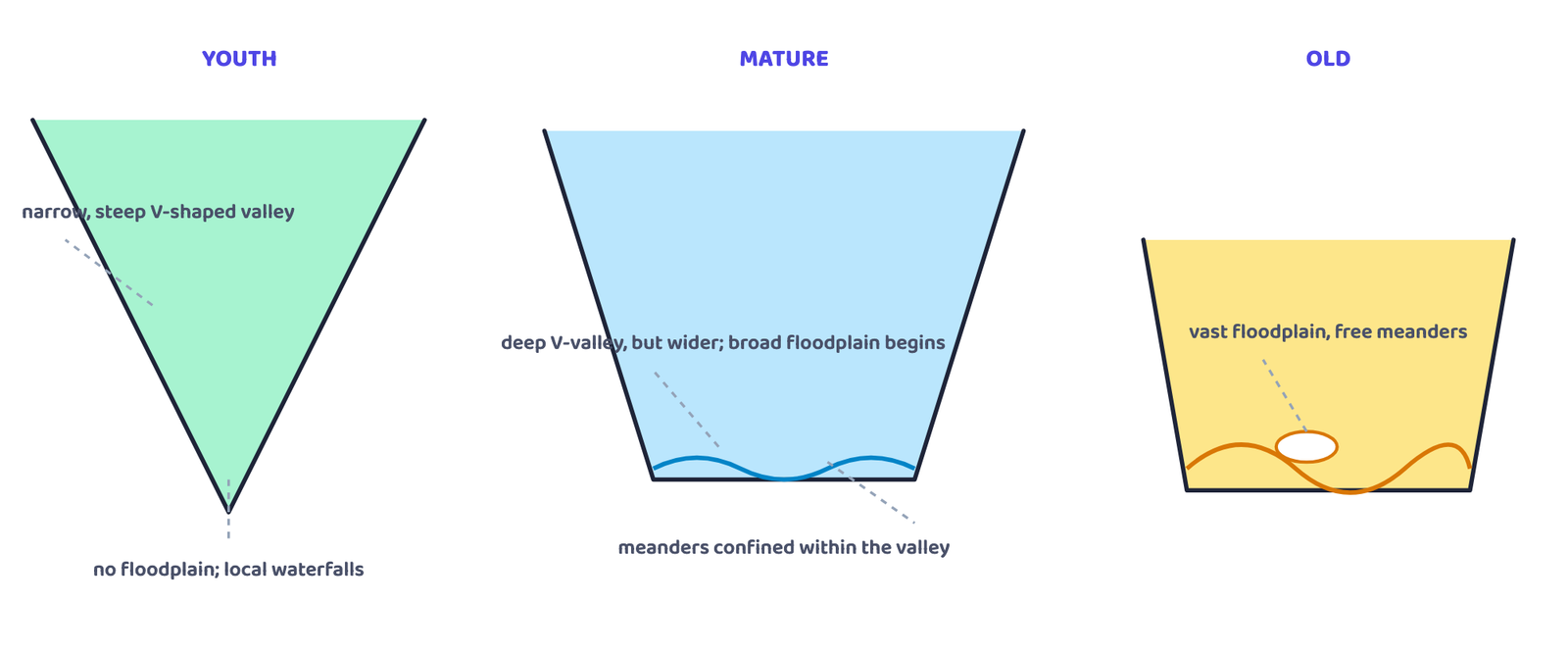
steep in youth, wide with a growing floodplain at maturity, and a vast, gently meandering
floodplain with oxbow lakes in old age. Schematic profiles, not any real river.
| Stage | Streams and integration | Valley and floodplain | Special features |
|---|---|---|---|
| Youth | Few streams, poorly integrated, flowing over the original slope | Shallow V-shaped valleys, no floodplain or a very narrow one along trunk streams | Broad flat divides with marshes, swamps and lakes; waterfalls and rapids where local hard rock is exposed; meanders on the broad upland surface may later cut down into it |
| Mature | Streams plenty and well integrated | Valleys still V-shaped but deep; trunk streams broad, with wide floodplains where streams meander within the valley |
Flat interstream areas and swamps of youth disappear; divides turn sharp; waterfalls and rapids disappear |
| Old | Few small tributaries with gentle gradients | Streams meander freely over vast floodplains, with natural levees and oxbow lakes | Divides broad and flat, with lakes, swamps and marshes; most of the landscape lies at or just above sea level |
A very common short question is “what is a peneplain, and what is left standing on it?” Answer
in one line: continued erosion by running water lowers a landmass to an almost flat plain called a
peneplain, and the only things left standing on it are isolated hills of resistant rock called
monadnocks.
2Running Water
In humid regions, which receive heavy rainfall, running water is the most important geomorphic
agent shaping the land. It has two components: overland flow, a sheet of water spread over
the general land surface, and linear flow, water channelled into streams and rivers within
valleys. Streams on steep gradients erode; as the gradient becomes gentler with continued erosion,
the stream slows down and deposition becomes active. The gentler the channel, the greater the
deposition.
2.1 Erosional landforms of running water
Valleys begin as small, narrow rills and grow into long, wide gullies. Depending on their
dimensions and shape, several distinct valley types can be recognised.
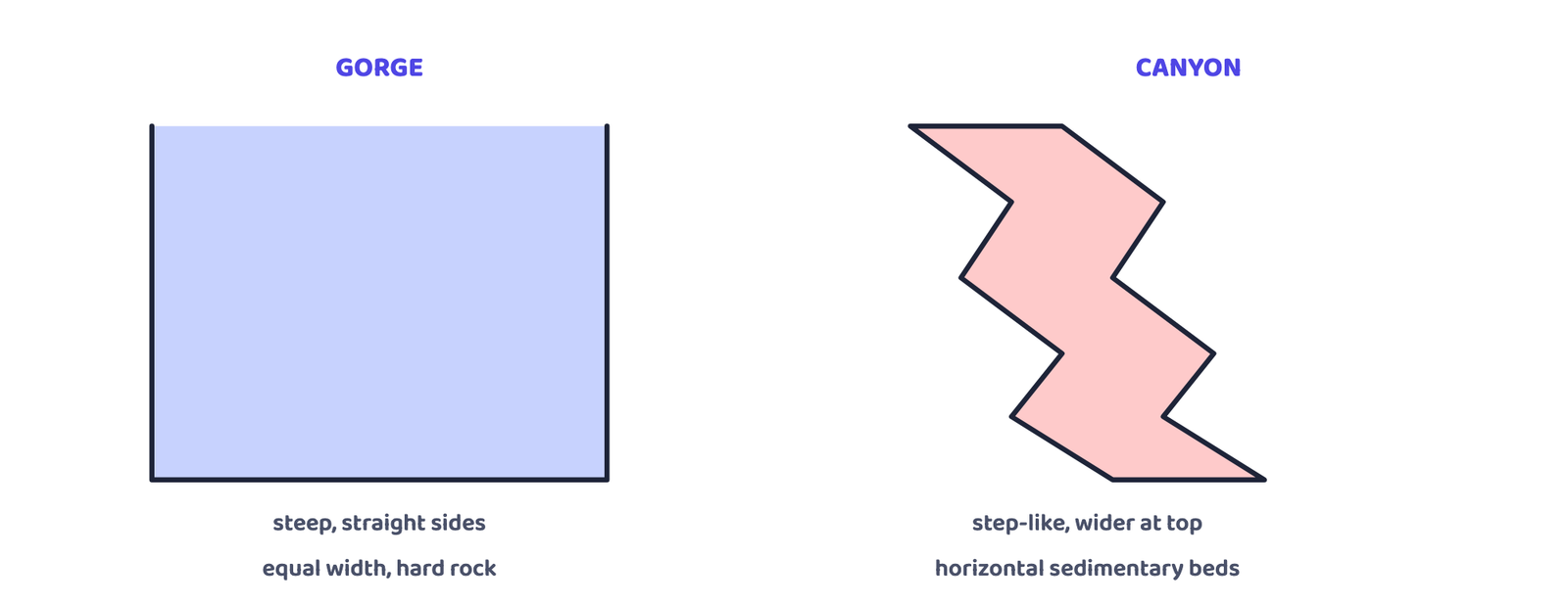
roughly equal width top and bottom, forming in hard rocks. A canyon has step-like side slopes and
is wider at the top than the bottom; it is really a variant of a gorge. Schematic cross-sections,
not a real location.
Potholes and Plunge Pools
Over rocky beds of hill-streams, more or less circular depressions called potholes
form due to stream erosion helped by the abrasion of rock fragments rotating in them. At the
foot of waterfalls, large, deep versions of the same feature are called plunge pools.
Incised or Entrenched Meanders
Very deep and wide meanders can be found cut into hard rock even where the stream flows over
a gentle gradient. Because they are cut deep into rock rather than into soft alluvium, they are
called incised or entrenched meanders.
River Terraces
River terraces mark old valley-floor or floodplain levels, either as bare bedrock surfaces or
as alluvial terraces of stream deposits. They form due to vertical erosion by the stream into
its own earlier floodplain. Terraces at the same elevation on either side of a river are called
paired terraces.
The NCERT textbook’s own photograph of a real gorge is the Kaveri river near Hogenekal,
Dharmapuri district, Tamil Nadu, where the river drops through a narrow, steep-sided channel
cut into hard rock, exactly the gorge shape drawn in Figure 2.
2.2 Depositional landforms of running water
Alluvial Fans
When a stream carrying coarse material from a mountain slope suddenly breaks onto a gentler
foot-slope plain, the load becomes too heavy to carry further and is dumped as a broad,
cone-shaped deposit called an alluvial fan. Fans are low and gently sloped in humid
areas, but high and steep in arid and semi-arid climates. Streams flowing over a fan often shift
across it, forming several channels called distributaries.
Deltas
A delta forms like a fan, but where a river’s load is dumped into the sea. Delta
deposits are well sorted, with clear layering: the coarsest material settles first and finer
silt and clay are carried further out. As a delta grows, its distributaries keep increasing in
length.
Floodplains, Natural Levees and Point Bars
A floodplain is the major depositional landform of a river. The river bed made of its
own deposits is the active floodplain; the ground above the bank, covered only when the
river floods, is the inactive floodplain. Natural levees are low, linear ridges of
coarse deposits along a river’s banks. Point bars (also called meander bars) are
sediments deposited along the bank in a meander, fairly uniform in width and made of mixed
sediment sizes.
A meander is a loop-like bend in a river’s course. It is not itself a landform,
only a type of channel pattern, caused by (i) water working laterally on the banks over very
gentle gradients, (ii) the unconsolidated, irregular nature of alluvial banks, and (iii) the
Coriolis force, which deflects flowing water sideways just as it deflects wind.
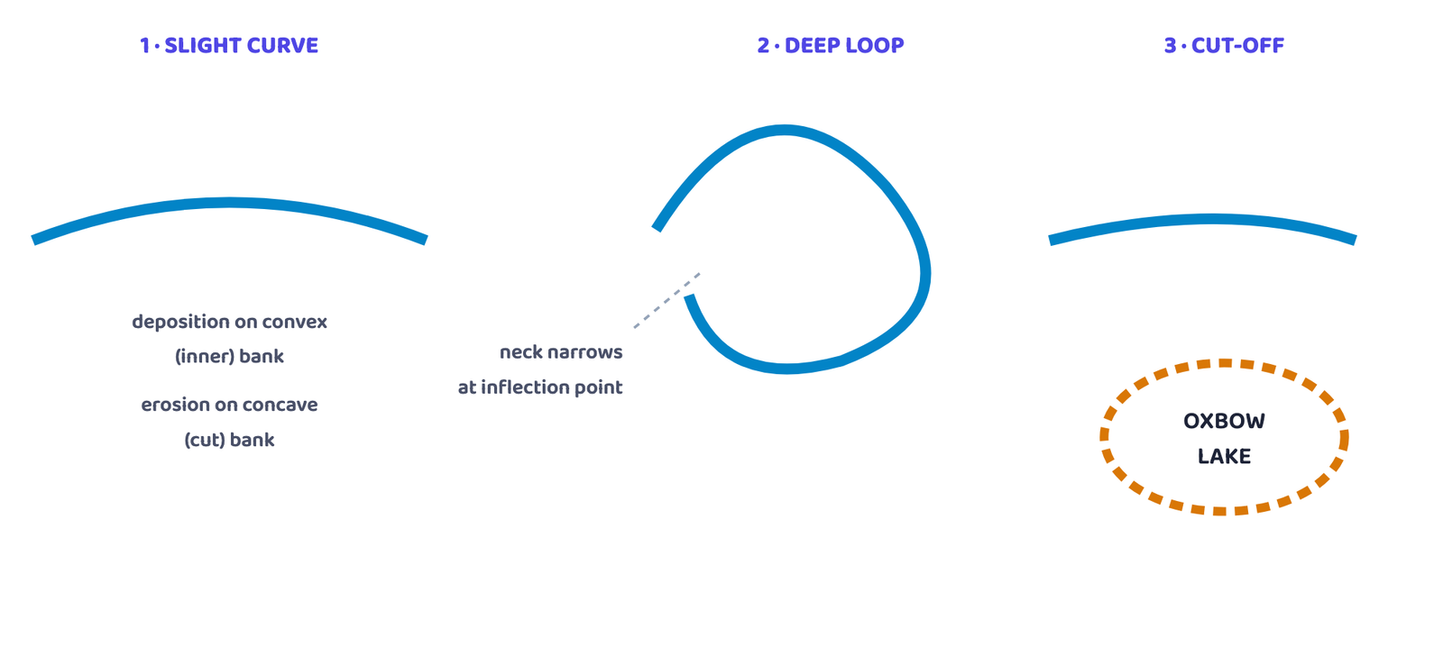
When the narrow neck at the inflection points finally gets cut through, the loop is abandoned as a
crescent-shaped oxbow lake. Schematic stages, not a real river course.
Do not call a meander a “landform” in an exam answer. The chapter is explicit: a meander is
only a channel pattern. The oxbow lake left behind when a meander is cut off, however, is a real
depositional landform.
3Groundwater
This section is not about groundwater as a resource, but about the erosional and depositional
work it does. Groundwater percolates well where rocks are permeable, thinly bedded and well
jointed. Mechanical removal of material by groundwater is insignificant; what matters is chemical
solution and precipitation, which is active mainly in limestone and dolomite, both
rich in calcium carbonate.
Karst topography is the set of distinctive landforms produced by the solution and
deposition work of groundwater on limestone or dolomite. It is named after the Karst region in
the Balkans, next to the Adriatic Sea, where such landforms were first studied.
3.1 Erosional landforms of karst
Sinkholes are sometimes covered by a thin mantle of soil and appear as shallow pools. Stepping
onto one is like stepping into quicksand: the ground gives way beneath the walker.
3.2 Depositional landforms of karst
Calcium carbonate dissolved in water is deposited again wherever the water evaporates or loses
its dissolved carbon dioxide while trickling over a rough cave surface, building up the characteristic
decorations of a limestone cave.
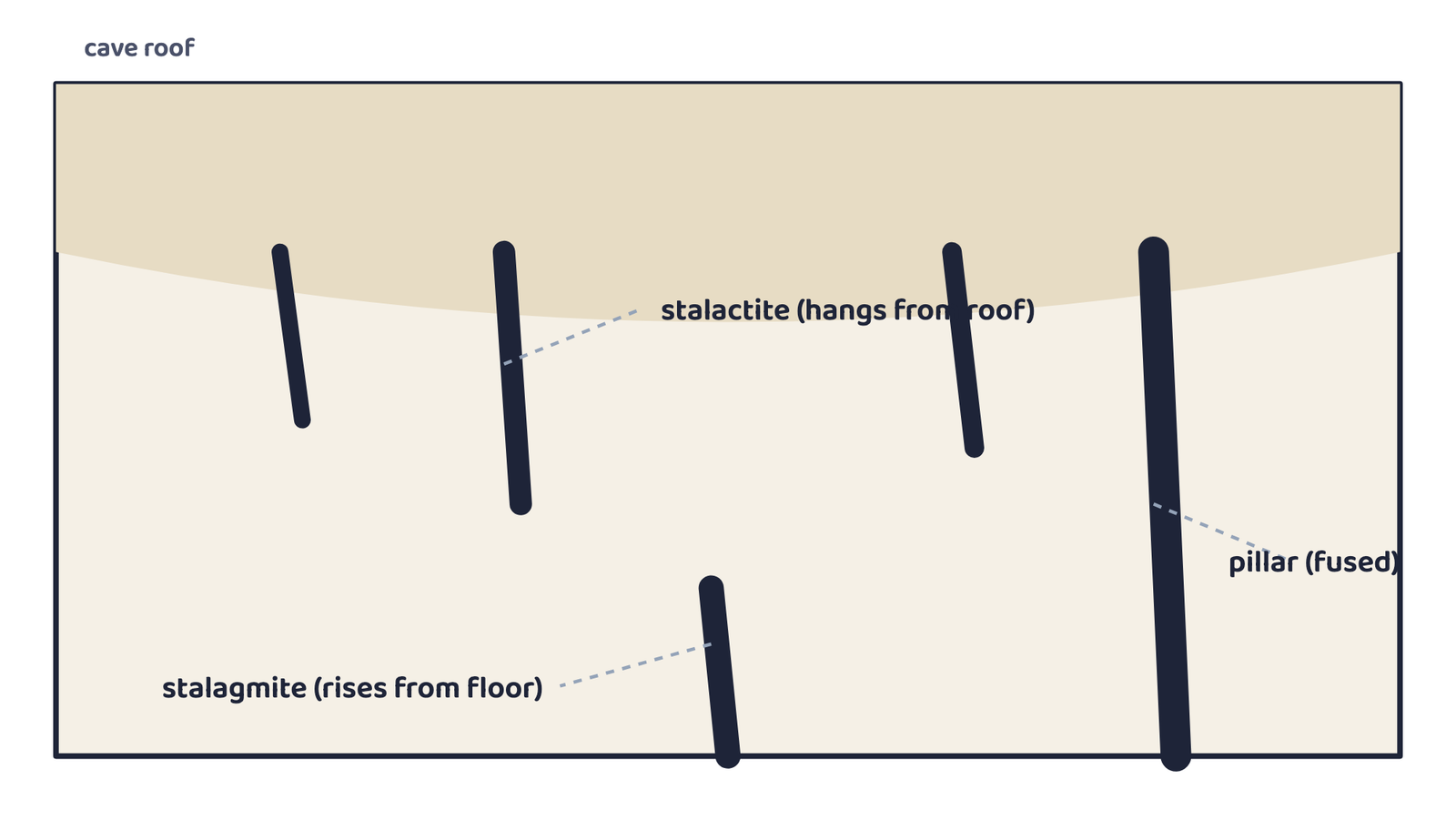
rise from the floor directly beneath the drip. Where the two eventually meet, they fuse into a
pillar. A schematic cave cross-section.
4Glaciers
A glacier is a mass of ice moving slowly, a few centimetres to a few metres a day, under the
force of gravity, either as a sheet over land (a continental or piedmont glacier) or
as a linear flow down a mountain valley (a valley or mountain glacier). Because ice is
so heavy, erosion by glaciers is tremendous: rock fragments dragged along the floor and sides of a
valley cause severe abrasion and plucking, powerful enough to reduce even high mountains to low
hills and plains.
India has real glaciers of its own, worth naming in a Himalaya-related answer: the Himalayas of
Uttaranchal, Himachal Pradesh and Jammu and Kashmir carry many. The Gangotri glacier’s snout, called
Gaumukh, feeds the river Bhagirathi; the Alkapuri glacier feeds the Alaknanda. The Bhagirathi
and Alaknanda join at Devprayag to form the river Ganga.
4.1 Erosional landforms of glaciers
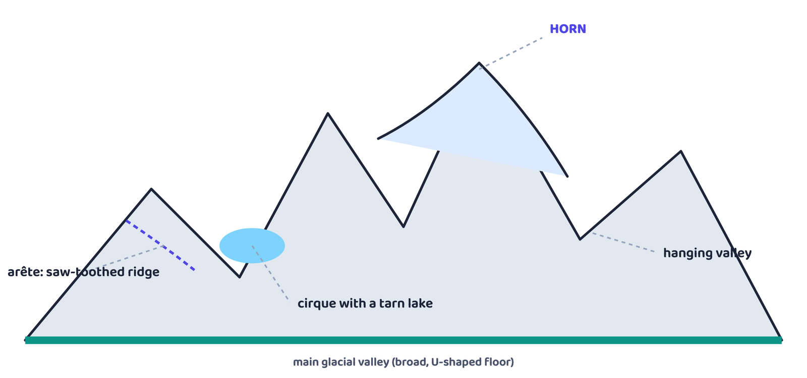
meet, they leave a sharp horn. The narrowing ridge between two cirques becomes a saw-toothed
arête. A tributary valley left stranded above the deepened main valley is a hanging
valley. Schematic mountain profile, not a real peak.
A cirque is a deep, long and wide trough or basin with steep, concave-to-vertical walls
at its head and sides, cut by accumulated ice at the head of a glacial valley. After the glacier
disappears, a lake often forms in it, called a cirque or tarn lake.
Matterhorn, the highest peak in the Alps, and Mount Everest, the highest peak in
the Himalayas, are both horns, sharpened by the headward erosion of cirques cutting in from
several directions at once.
Glacial valleys (troughs) are U-shaped with broad floors and steep, smooth sides, often
containing lakes or till. Very deep glacial troughs, later filled by the sea, form fjords
along high-latitude coastlines.
4.2 Depositional landforms of glaciers
Unsorted debris of all sizes dumped directly by melting ice is called glacial till,
mostly angular to sub-angular in shape. Material carried and sorted by glacial meltwater streams
instead is called an outwash deposit, roughly stratified with rounded edges.
| Depositional landform | What it is |
|---|---|
| Terminal moraine | A long ridge of till deposited at the toe (end) of a glacier |
| Lateral moraine | A ridge along the sides of a glacial valley; may join a terminal moraine into a horse-shoe shape |
| Ground moraine | An irregular sheet of till left behind as a valley glacier retreats rapidly |
| Medial moraine | A ridge in the centre of a valley, flanked by lateral moraines; often poorly formed and hard to tell apart from ground moraine |
| Esker | A sinuous ridge of coarse material left by a stream that once flowed in a channel beneath the ice |
| Outwash plain | Broad, flat alluvial fans of glacio-fluvial gravel, silt, sand and clay at the foot of glacial mountains or beyond an ice sheet, that may join into a plain |
| Drumlin | A smooth, oval, ridge-like hill of till, up to about 1 km long and 30 m high; the blunt, steep stoss end faces the glacier and the tapering tail points away, showing the direction of ice movement |
“Distinguish between till and outwash deposits” is a favourite 30-word question. One line each:
till is unsorted, angular debris dropped directly by ice; outwash is sorted, rounded, stratified
debris carried and deposited by glacial meltwater.
5Waves and Currents
Coastal processes are the most dynamic and destructive of all: erosion in one season can be
followed by deposition in the next at the very same spot, and a single storm or tsunami can do more
damage than years of ordinary waves. Assuming sea level stays constant, coastal evolution is best
understood by comparing two contrasting kinds of coast.
High, rocky (submerged) coasts
- Rivers appear “drowned”; the coastline is highly indented
- Fjords appear where old glacial valleys meet the sea
- Erosion features dominate; hillsides drop sharply into the water
- India’s west coast is of this type: a high, rocky, retreating coast
Low, sedimentary (emerged) coasts
- Rivers extend their length by building coastal plains and deltas
- The coastline is smooth, broken only by lagoons and tidal creeks
- Depositional features dominate; marshes and swamps are common
- India’s east coast is of this type: a low sedimentary coast
5.1 Erosional landforms of high rocky coasts
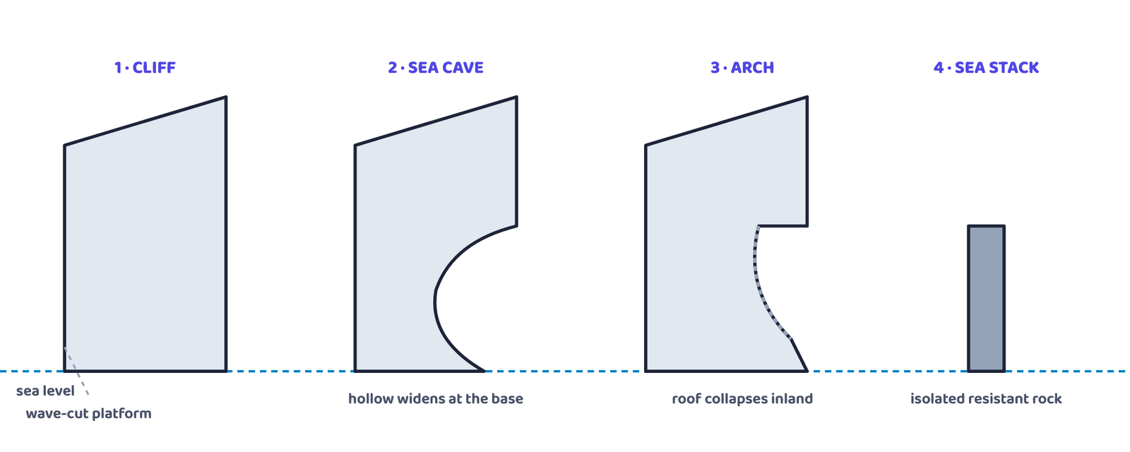
cave, the cave’s roof collapses to leave an arch, and the arch finally collapses to leave an
isolated sea stack. Schematic sequence, not a real coastline.
5.2 Depositional landforms of low sedimentary coasts
Beaches and Dunes
Beaches are temporary accumulations of sand or, in shingle beaches, small pebbles and
cobbles. Wind lifts sand from just behind the beach and deposits it as sand dunes, often
forming long ridges parallel to the coast.
Bars, Barriers and Spits
An offshore bar is a submerged ridge of sand or shingle roughly parallel to the coast.
Once exposed by more sand, it becomes a barrier bar. A barrier bar keyed onto a headland
is called a spit.
Lagoons
When barrier bars and spits grow across the mouth of a bay and seal it off, the enclosed
water body is a lagoon. Sediment from the land gradually fills a lagoon, turning it into a
coastal plain.
Offshore bars are the coast’s first line of defence against a storm or tsunami, absorbing much
of the wave’s force before it reaches land. Behind them, barriers, beaches, dunes and mangroves
(where present) take up the rest. Damaging any of these leaves the coast, and the people living on
it, more exposed to the next big wave.
6Winds
Wind is one of two dominant agents shaping hot deserts, and it is not the only one: deserts get
rain rarely, but when it comes it falls torrentially, so sheet floods of rainwater also move a great
deal of weathered material. Wind itself acts in three ways: deflation (lifting and removing
dust and fine particles), abrasion (sand grains sand-blasting a rock surface as they are
carried past it), and impact (the sheer force of a grain striking a surface).
6.1 Erosional landforms of deserts
A pediment is a gently inclined rocky floor at the foot of a mountain, with or without a
thin cover of debris, formed by lateral stream erosion combined with sheet flooding. As pediments
extend backwards through the parallel retreat of slopes (backwasting), the mountain is
gradually reduced to a low, featureless pediplain, leaving behind an isolated remnant of
the old mountain called an inselberg.
| Landform | How it forms |
|---|---|
| Playa | A shallow, temporary lake at the centre of a desert basin, where drainage from surrounding hills converges; often leaves rich salt deposits when it dries |
| Alkali flats | A playa plain that has become covered with salt after repeated drying |
| Deflation hollows | Shallow depressions created where wind persistently blows away weathered mantle or loose soil |
| Caves (in deserts) | Shallow “blow-out” pits deepen and widen through continued wind abrasion until they are large enough to be called caves |
| Mushroom, table and pedestal rocks | Rock outcrops worn unevenly by wind deflation and abrasion, leaving a resistant cap on a narrower stalk |
6.2 Depositional Landforms: Sand Dunes
Wind is a good sorting agent: as it slows down, grains settle out according to size. Given an
obstacle and a steady sand supply, several distinct dune shapes can form.
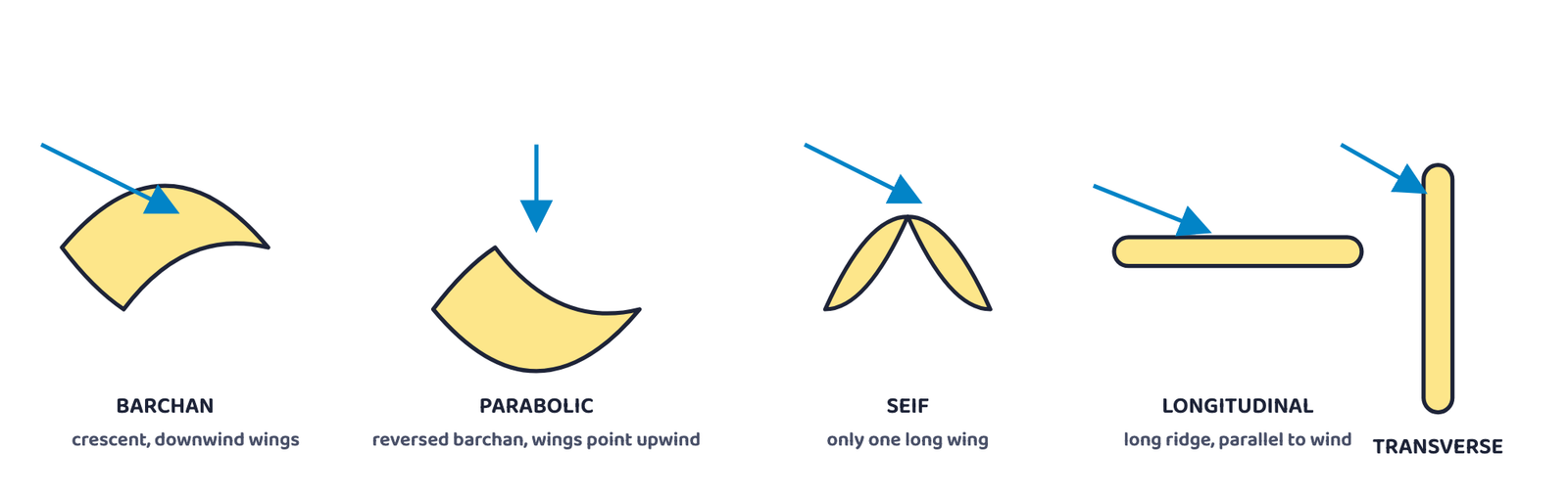
direction: the crescent-shaped barchan, the reversed-crescent parabolic dune, the single-winged
seif, and longitudinal and transverse ridges. Schematic outlines, not to scale.
Do not write that a parabolic dune is just another barchan. The chapter calls it a “reversed
barchan”: its wings point into the wind (upwind), the opposite of a barchan’s downwind
wings, and it forms where vegetation partly covers a sandy surface.
- Can I define landform and landscape, and explain the youth-mature-old stages of a river
valley, without looking? - Can I explain the difference between a gorge and a canyon?
- Can I list the erosional and depositional landforms of running water, groundwater, glaciers,
coasts and wind, one set at a time? - Can I explain why a meander is not a landform, but an oxbow lake is?
- Can I name and describe all five kinds of sand dune?
- Landform = small-medium surface tract; landscape = many landforms together; evolution = the
stages of change a landform passes through, compared to youth, mature and old age - Running water: youth (V-valleys, no floodplain) → mature (deep V, growing floodplain) → old
(vast floodplain, free meanders, oxbow lakes); gorge (steep, equal width) vs canyon (step-like,
wider at top); alluvial fans and deltas form where load is dumped; a meander is a channel
pattern, not a landform - Groundwater dissolves limestone into karst topography: sinkholes, dolines, uvalas, lapies,
caves and tunnels (erosional); stalactites, stalagmites and pillars (depositional) - Glaciers carve cirques, horns, arêtes, glacial troughs and fjords; they deposit till as
terminal, lateral, ground and medial moraines, plus eskers, outwash plains and drumlins - High rocky coasts (India’s west) are erosional: cliffs, wave-cut platforms, caves, arches,
sea stacks. Low sedimentary coasts (India’s east) are depositional: beaches, dunes, bars,
barriers, spits, lagoons - In deserts, wind (deflation, abrasion, impact) plus rare sheet floods carve pediments,
pediplains, inselbergs, playas and deflation hollows, and deposit barchan, parabolic, seif,
longitudinal and transverse dunes
- 1 markIn which stage of landform development is downward cutting dominant?
(a) Youth stage(b) Late mature stage
(c) Early mature stage(d) Old stage - 1 markA deep valley with steep, step-like side slopes is known as a:
(a) U-shaped valley(b) Gorge
(c) Blind valley(d) Canyon - 1 markIn which region is the chemical weathering process more dominant than the mechanical process?
(a) Humid region(b) Limestone region
(c) Arid region(d) Glacier region - 1 markWhich sentence best defines the term “Lapies”?
(a) A small to medium sized shallow depression
(b) A landform whose opening is circular at the top and funnel-shaped towards the bottom
(c) A landform formed by dripping water from the surface
(d) An irregular surface with sharp pinnacles, grooves and ridges - 1 markA deep, long, wide trough or basin with steep concave-to-vertical walls at its head and sides is known as:
(a) Cirque(b) Glacial valley
(c) Lateral moraine(d) Esker - 1 markA landform is defined as:
(a) Any large plateau or mountain system
(b) A small to medium tract of the earth’s surface with its own shape, size and material
(c) A country’s entire coastline(d) A river’s complete drainage basin - 1 markThe near-flat surface left after a long period of river erosion, dotted with resistant hills, is called a:
(a) Pediplain(b) Peneplain
(c) Floodplain(d) Outwash plain - 1 markThe Karst region that gives karst topography its name lies in the:
(a) Alps, next to the Mediterranean(b) Balkans, next to the Adriatic Sea
(c) Andes, next to the Pacific(d) Rockies, next to the Arctic Ocean - 1 markA barrier bar keyed up to a headland is called a:
(a) Lagoon(b) Spit
(c) Delta(d) Fjord - 1 markA crescent-shaped sand dune whose wings point downwind is called a:
(a) Seif(b) Parabolic dune
(c) Barchan(d) Transverse dune
Reason (R): The chapter states that a meander is only a channel pattern, caused by lateral erosion, unconsolidated banks and the Coriolis force, not a landform in itself.
Reason (R): India’s east coast is a low sedimentary coast, along which depositional landforms such as beaches, spits and lagoons dominate.
- 3 marksWhat do incised meanders in rocks and meanders in plains of alluvium indicate?
- 3 marksExplain the evolution of valley sinks or uvalas.
- 3 marksUnderground flow of water is more common than surface run-off in limestone areas. Why?
- 3 marksGlacial valleys show up many linear depositional forms. Give their locations and names.
- 3 marksHow does wind perform its task in desert areas? Is it the only agent responsible for erosional features there?
- 3 marksDistinguish between a stalactite and a stalagmite.
- 5 marksRunning water is by far the most dominant geomorphic agent in shaping the earth’s surface, in both humid and arid climates. Explain.
- 5 marksLimestones behave differently in humid and arid climates. Why? What is the dominant geomorphic process in limestone areas, and what are its results?
- 5 marksHow do glaciers accomplish the work of reducing high mountains into low hills and plains?
into deep, narrow-necked bends. During one flood, the river cuts straight through the narrow neck
of one such bend, abandoning the old loop.
- 1 markWhat is this loop-like bend in the river’s course called, before it is cut off?
- 2 marksWhat landform does the abandoned loop become, and why does its curved shape stay visible for a long time?